Visitors

Sunday, January 31, 2016

How 11 Legendary Outdoor Destinations Formed


IMAGE CREDIT:
ISTOCK

Hardcore adventurers will really go the distance in order to ski, surf, swim, or soar in Earth’s most incredible landscapes, but the places themselves have come a long way, too—here’s a few examples of some of their most radical geologic journeys.

1.BADLANDS NATIONAL PARK // SOUTH DAKOTA

The gorgeous views one can enjoy walking the many hiking trails in Badlands National Park were formed by a pair of simple processes: deposition and erosion. First, many layers of sedimentary rock began to form some 75 million years ago, and continued to pile up with everything from volcanic ash to alligator fossils. Then, about 500,000 years ago, the Cheyenne River brought waterways flowing from the nearby Black Hills into the Badlands and began to carve away at the rock, creating the incredible landform we see today. It’s estimated that in another 500,000 years, the process will be complete, and the Badlands will have been completely chipped away.

2. ULUWATU BEACH // BALI


Located on the southwestern side of the Bukit Peninsula, this famed beach is one of the best-known surf destinations in the world. It’s surrounded by limestone cliffs that were formed as a result of the subduction of the Indo-Australian Plate under the Eurasian Plate (or possibly the Australian plate under the Sunda plate), bringing it above sea level. The imposing cliffs looming over the surf mean that this isn’t just one of the best places to catch a wave, it’s also one of the most beautiful. 

3. DEVILS TOWER NATIONAL MONUMENT // WYOMING


Devils Tower is one of the go-to destinations in the world for serious rock climbers, but it’s also a geological formation worth simply marveling at. The rock rises up 1,267 feet above the Belle Fourche River, and began its formation over 200 million years ago. The oldest sediment was laid when the area was covered in a shallow sea, and more layers continued to form as bodies of water came and went. The tower itself was formed from magma: About 50 million years ago, molten rock pushed toward the earth’s surface and forced its way into the sedimentary rock layers. Geologists don’t agree on exactly what occurred beyond the introduction of igneous material, but it’s likely that magma simply cooled, crystallized, and contracted while hardening to form the hexagonal columns. After many years of erosion, the soft sedimentary rocks disappeared, leaving behind the much sturdier igneous rock that makes up Devils Tower. And as time goes by, more and more of this amazing feature will be exposed at the surface until it too erodes away. 

4. THE GALAPAGOS ISLANDS // ECUADOR


This archipelago of 13 major islands is still being formed to this day, and as a whole, is considered relatively young in geologic terms: The oldest existing island is around five million years old and the youngest is around 700,000 years old. The chain is formed from hotspot volcanism; the Nazca tectonic plate is moving over a hot area of the mantle, and so it continuously forms volcanoes that rise to the surface and create new islands. And once the new island has moved past the hotspot, the process starts all over again and a new island forms. Truly a dynamic landscape, about 50 eruptions have occurred there in the last 200 years. It’s those eruptions that give the islands their conical shape.

5. THE ALPS


Best known for skiing, the Alps are also a famed destination for mountain bikers who hit the trails on wheels instead of skis. The awesome (in the truest sense of the word) mountains are part of an orogenic belt of mountain chains that runs through Europe and Asia. The African and Eurasian tectonic plates collided, causing sediment in the ancient Tethys Ocean to get pushed up. Later on during the Ice Age, glaciers traveled down the valleys, carving out space along the way, then created the alpine lakes as they melted. We imagine the skiing would have been really spectacular then. 
 
6. THE SOUTHERN ALPS


The other Alps live across the equator and make for another epic skiing site. Geologically speaking, the Southern Alps are young—only about five million years old, and are still in the process of changing. Similar to their northern brethren, the Southern Alps are a result of tectonic plate action, this time at the Pacific and Australian plates. The mountains continue to rise as the plates collide and push up the land; in some areas, they’ve risen as much as 65,000 feet in the last three million years. As they rise, high rainfall and glaciers, which sculpted valleys and filled them up (along with large deposits of rock and debris) as they melted, caused erosion.

7. MAMMOTH CAVE // KENTUCKY


For those who want to adventure underground, there’s Mammoth Cave—a system of subterranean tunnels, the oldest of which formed around 10 million years ago. Rewind back even further to about 325 million years ago, and you’d see a massive sea that covered much of what is now the heartland of the United States. This sea deposited 600 feet of limestone over the area, and eventually it was covered by sturdier sandstone and shale. After millions of years of erosion, the soft limestone began to peek through the covering layer, and rainwater did the rest to hollow out the cave. 

8. FUTALEUFU RIVER // CHILE


For the best white water rafting in South America (or arguably the world), brave souls venture to the Futaleufú in Northern Patagonia. Much of the region was shaped by glaciers that worked the terrain over the last 800,000 years, forming the Andean lakes and many of the area’s high-octane rivers. The gorgeous blue waters of Futaleufú are the result of glacier runoff, and are part of a vast system of waterways, fed by waters from Argentina and flowing out (eventually) into the Pacific Ocean.

9. GLACIER BAY // ALASKA


We’ve touched on a few “new” geographical features, but Alaska’s Glacier Bay is like a brand new baby in comparison to those other guys. The magnificent kayaking and sightseeing spot wasn’t even there when Captain George Vancouver toured the coast in 1794 because it was underneath a sheet of glacial ice. Since then, it’s retreated 65 miles, creating a new bay and revealing new swaths of land. The bay is also where the American and Pacific tectonic plates have been colliding for over 100 million years. This impact has led to accumulation of “terranes,” which are fragments of crustal material. It’s one of the most dynamic areas on the planet, resulting in breathtaking landscapes that literally change every single day (though at a rate you won’t be able to spot with the naked eye).

10. ARCHES NATIONAL PARK // UTAH


This area is a treasured spot for bikers, hikers, climbers, and campers, and it’s all thanks to a series of geological process hundreds of millions of years in the making. Rock layers began forming around 300 million years ago when Utah was covered in an ancient sea. Water levels rose and fell in a cycle for years, leaving massive salt deposits that, under great pressure, rose up into a dome and became the basis for the unique rock features in the area. Later on, sandstone deposits and sand dunes formed, then mudflats, which continued to see the oceans flood and recede, all before the area became a desert, with cliffs carved out from wind and ice erosion. Sediment continued to deposit and erode (which by now, you can see is a common origin story), and today, the terrain is still quite fragile despite its imposing grandeur.

11. ARENAL VOLCANO // COSTA RICA


Costa Rica kind of hit the geological jackpot. It has the Caribbean Sea to the east and the North Pacific Ocean to the west and about 800 miles of coastline, with rain forests, coastal plains, and rugged mountains. It also happens to be the site of subduction of the Cocos tectonic plate under the Caribbean Plate, which has resulted in a chain of mountains that includes Arenal Volcano. There, you can zip line for two miles through the jungle, over a lake, and swoop by the volcano for a quick hello. It last erupted in 2010, and is still active, though constant monitoring means you won’t even see lava as you glide by.

Saturday, January 30, 2016

Literary travel: around the world in 10 must-read books

Ann Morgan spent a year reading a book from every country in the world – 196 in total. Here she picks 10 favourites that vividly evoke the regions they describe:
In 2012, I embarked on an eccentric project. Having realised how anglocentric my reading was, I decided to try to read a novel, short story collection or memoir from every UN-recognised country, plus former UN member Taiwan (then 196 nations in all), in a calendar year.

I set up a blog, ayearofreadingtheworld.com, and asked the world’s book lovers to help me. Pretty soon suggestions – and even books, manuscripts and unpublished translations – were flooding in from around the planet.

My criteria for choosing the titles I read varied and developed throughout the year. Sometimes I opted for national favourites. At other times I picked wildcards that intrigued me because they seemed at odds with the society that had produced them, such as works by exiled writers. And there were narratives that challenged my preconceptions in a huge number of ways.

Not all the books I read were set in the countries in question, but many were evocative of the regions they describe. Since then I’ve continued to seek out books that transport me to a different place. Here are 10 of my favourites:

Bhutan


The Circle of Karma by Kunzang Choden 

Following a young woman on her quest for enlightenment, this novel takes readers on a tour of the Buddhist gompas of the Himalayas in Bhutan and northern India, revealing marvels along the way. Seeing the religious sites through the eyes of a believer is a powerful experience, as are the descriptions of the majestic landscape and desperate living conditions the protagonist encounters. It is also the first book by a female Bhutanese author to be published outside Bhutan.

Switzerland


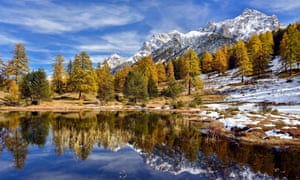
Snow-covered mountains and autumnal forest reflected in the Lai Nair, Tarasp, Switzerland. Photograph: Alamy

Beauty on Earth by Charles-Ferdinand Ramuz, translated from the French by Michelle Bailat-Jones
The early-20th-century Swiss writer Charles-Ferdinand Ramuz uses a visual artist’s sensibility to capture life on the shores of a central European lake in this tale of a young Cuban immigrant’s arrival in a rural community. Small details are rendered with fine brushwork: “a ladder of sunshine … descended from a hole in the sky,” a leaf “wrinkled up … like a duck’s foot”. The result is a mesmeric picture, from which we can step back in the final pages to appreciate the full effect.

Angola


Our Musseque by José Luandino Vieira, translated from the Portuguese by Robin Patterson
The shanty towns in Luanda, the capital of Angola, in the 1940s and 1950s, come are vividly depicted in this idiosyncratic novel published more than 40 years after the author wrote it, in prison. Prostitutes, shopkeepers, children and drunks jostle and collide, giving conflicting accounts of their experiences as the civil war approaches, a conflict that will change their lives for good. Funny, shocking and moving, it makes you nostalgic for a place you have never been.

South Africa
The township of Soweto, Johannesburg. Photograph: Ben Curtis/AP

African Delights by Siphiwo Mahala
Roving between South Africa’s townships and the country’s wealthier districts, this irreverent, bold and engrossing collection of interlinked stories captures the complexities, contradictions and tensions of the country in the late 20th century. The sharp contrasts in the settings highlight the injustices woven into the society, while the humour and winning audacity of many of the disadvantaged characters make the cruelty of the insults they have to live with all the more telling. At times you feel as though you are sitting at their kitchen tables listening to their stories.

Myanmar


Smile as they Bow by Nu Nu Yi, translated from the Burmese by Alfred Birnbaum and Thi Thi Aye
A spirit festival in a small Burmese village is the backdrop to this absorbing novel, one of the few books from Myanmar to have been translated into English. Nu Nu Yi’s sensual descriptions of the hustle and bustle of the event – to which people from all walks of life flock to pay dancers to perform as a way of atoning for their misdeeds and drawing down blessings – are a joy to read. The colourful setting is second only to the vitality of the central character, Daisy Bond, a foul-mouthed transgender spirit dancer with a talent for deception.
Pakistan


The Wandering Falcon by Jamil Ahmad
Some descriptions can be as breathtaking as the landscapes they depict, and Pakistani author Jamil Ahmad’s certainly fits into that category. As the novel follows his nomadic protagonist, Tor Baz, the wild and treacherous hill country around the borders of Pakistan, Iran and Afghanistan unfolds in all its harsh beauty. Reading the book can feel like picking your way over its mountain crags, or standing on the plains watching pursuers approach through the clouds of dust whipped up by the region’s 120-day winds.
Grenada


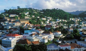
St George’s, the capital of Grenada. Photograph: Nik Wheeler/Alamy

The Ladies are Upstairs by Merle Collins
Psychogeography has a significant role to play in this lively collection of short stories, in which colonial history haunts the landscape of present-day Grenada. Eerie encounters on lonely roads and the pomp of the architecture of centuries past combine to present a richer and more engrossing picture of the “Island of Spice” than tourist brochures could ever do. Through it all runs a powerful sense of community, warmth and humanity.

Equatorial Guinea


By Night the Mountain Burns by Juan Tomás Ávila Laurel, translated from the Spanish by Jethro Soutar
The tiny isle of Annobón, a province of Equatorial Guinea, bursts from the page in this glorious novel. Packed with details about island life: from how you make a canoe out of a tree trunk and the practicalities of cutting dates off palm trees, to the songs and superstitions that bind the society together. The book bubbles with interest, while its narrative is based on the region’s oral traditions. As a result it melds the familiar with the strange to draw us into the landscape and community of the island. This is only the second novel from Equatorial Guinea to be translated into English, so it is a rare and precious window on a little-known part of the globe.

UK/Wales


Martha Jack and Shanco by Caryl Lewis, translated from the Welsh by Gwen Davies
The west Wales landscape is a key player in this haunting novel about three ageing siblings who have spent their lives on their parents’ farm. Lewis writes in such a way that the harsh cold and comfortlessness of the place seem to seep out of the pages to hold you in their grip, even as flashes of natural beauty burst from the text. It is a stark reminder that you don’t have to travel far from home to find yourself in a different world.
Peru


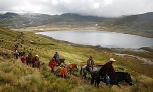
 Perol lake in Peru’s Cajamarca region. Photograph: Enrique Castro-Mendivil/Reuters

Death in the Andes by Mario Vargas Llosa, translated from the Spanish by Edith Grossman
Peruvian Nobel prize-winner Mario Vargas Llosa’s chilling tale is of murder, terrorism and vengeful spirits in the mountains. At once menacing and beautiful, his landscape is as unpredictable as the bands of outlaws that roam through it, plaguing the imagination of Corporal Lituma and his junior officer, who are charged with investigating disappearances in the mining community around their post. Unsettling and memorable.

• Beside Myself by Ann Morgan is published by Bloomsbury Circus (£12.99) on 14 January 2016. To order a copy for £10.39, including UK p&p, visit the Guardian Bookshop

Friday, January 29, 2016

There's Something Enormous Buried Beneath the East Antarctic Ice Sheet


Maddie Stone
Gizmodo


Every week, we’re bombarded with images of dazzling terrains on Mars and Pluto, but there are still geologic wonders to be discovered right here on Earth. Case in point: a new study suggests there could be a canyon system more than twice as long as the Grand Canyon buried beneath an ice sheet in Antarctica. If confirmed, the frozen chasm would be the world’s longest by a wide margin.

Faint traces of a ravine system stretching across the remote Princess Elizabeth Land in East Antarctica were first spotted by satellite images. A team of geologists then used radio-echo sounding, wherein radio waves are sent through the ice to map the shape of the rock beneath it. The results of this analysis, published recently in the journal Geology, reveal a chain of winding features over 600 miles long and half a mile deep buried beneath miles of ice.

According to the researchers, the scarred landscape was probably carved out by liquid water long before the ice sheet grew. Satellite images also suggest that the canyon might be connected to a previously undiscovered subglacial lake, one that could cover up to 480 square miles.

“It’s astonishing to think that such large features could have avoided detection for so long,” lead study author Steward Jamieson of Durham University said in a statement.

Astonishing, yes—but not quite confirmed. We won’t know for sure that this canyon really exists until Jamieson’s preliminary results are verified by a comprehensive radio-echo sounding analysis of the entire landscape. That airborne survey is scheduled to take place later this year.

If its existence is confirmed, the canyon system will become the world’s longest, handily stealing the title from Greenland’s Grand Canyon, which covers over 460 miles. Astonishingly, that canyon wasn’t discovered until 2013, when remote sensing data allowed scientists to peer through thick ice and reconstruct the rugged topography below. If one thing is clear from this recent spate of geologic finds, it’s that the age of discovery is far from over.

Read the full scientific paper at Geology.

Monday, January 25, 2016

A 'slow' earthquake along Washington’s coast reveals something fascinating about the way the Earth moves

Dana Hunter, Scientific American
Jan. 13, 2016, 1:57 PM


USGS. The Cascadia subduction zone.

We got a present from the Juan de Fuca Plate, which is subducting under the North American Plate: a slow earthquake! Did you even know an earthquake could be slow?

We're used to thinking of earthquakes as events that happen over seconds to a few minutes and produce a lot of shaking, but some earthquakes actually mosey along over hours or days, their trembling so gentle only seismometers can recognize it. One of these earthquakes started in the Cascadia Subduction Zone on December 21st and has been making its slow way south from Vancouver Island, British Columbia, Canada ever since.

Shelley Chestler at the Pacific Seismic Network has an excellent article on it. It's a feast of helpful illustrations and a clear explanation of what's going on, and I encourage you to read it in full if you want to know more about what's going on around one of the most dangerous fault zones in
North America. 
.

USGSA map of the juan de fuca plate, showing the subduction zone off the west coast of North America.


I'm terrified of Cascadia, so you'd think I'd be freaked out about now, right? But no, I'm totally relaxed. This is all completely normal stuff for this area. We do, of course, need to be aware of the dangers and not let normal lull us into a false sense of invulnerability. Subduction zones like Cascadia regularly produce enormous, devastating quakes, and we've got to be ready for when, not if, the Big One comes. But the current activity isn't reason to panic.

It is a reason to geek out, however! You can watch a very fun video showing four years of tremors in the Cascadia Subduction Zone here. It gives you an excellent sense of how active this place is! If you're intrigued, you can find out more about the tremors here. For a map of subduction zones worldwide, click here.

Subduction zones are terrifying. But they're also some of the most interesting and beautiful places on Earth, which is why I'm quite happy to live in one despite the danger!

This story was originally published by Scientific American.

Friday, January 22, 2016

Early data shows 2015 blew away previous records to become Earth's hottest year


Global temperature anomaly for 2015 compared to the 1951-1980 average.

BY ANDREW FREEDMAN


During the next week, the official climate agencies around the world that are responsible for tracking the planet's average temperatures will almost certainly come to the same conclusion: 2015 was the warmest year on record. This would mean that 2015 would beat the previous warmest year, which occurred in 2014 — remember that?

The combination of a record strong El Niño event plus the highest amount of greenhouse gases in the atmosphere at any time in human history have given the climate system the equivalent of a Power Bar plus a shot of espresso. On Wednesday, one unofficial temperature tracking group, known as Berkeley Earth, revealed its determination that 2015 was by far the planet's warmest year, both on land and sea.

There's one especially important about fact about this group's determination: It was set up in early 2010 as an independent fact check of other surface temperature data sets, and led by a physicist — Richard Muller — who had previously been quite skeptical of mainstream climate science findings. Instead of proving surface data from government agencies like NASA and the National Oceanic and Atmospheric Administration (NOAA) wrong, the Berkeley group has consistently reaffirmed their data.

The Berkeley Earth group said in a release on Wednesday that "2015 was unambiguously the hottest year on record." More importantly, the group found that for the first time in recorded history, the Earth’s temperature is clearly more than 1 degree Celsius (1.8 degrees Fahrenheit) above the 1850-1900 average, and halfway to world leaders' climate target of limiting global warming to under 2 degrees Celsius (3.6 degrees Fahrenheit) above average.

“At the recent rate of warming may begin to cross that threshold in about 50 years,"“At the recent rate of warming may begin to cross that threshold in about 50 years," Robert Rohde, a scientist with the Berkeley Earth team, said in the release.

At the Paris Climate Agreement, agreed to in December by every country in the world, leaders pledged to hold global warming to "well below 2 degrees Celsius", or 3.6 degrees Fahrenheit, above preindustrial levels and "to pursue efforts to limit the temperature increase to 1.5 degrees Celsius", or 2.7 degrees Fahrenheit, above preindustrial levels through 2100. Warming greater than 2 degrees would increase the risk of dangerous impacts of global warming on low-lying island nations, as sea levels rise, and have more dramatic effects on other vulnerable nations, such as Bangladesh and the nations of Sub-Saharan Africa.

In the Berkeley record, 2014 tied with 2005 and 2010 as the world's hottest year on record, whereas NOAA and other agencies had ranked it as the warmest. The Berkeley Earth team found that 2015 set the record with "99.996% confidence."

Berkeley Earth has taken a "cautious approach to announcing hottest years," according to the group's cofounder, Elizabeth Muller. "A year ago, we announced that 2014 was not a clear record, but only in a statistical tie with 2005 and 2010. Now, however, it is clear that 2015 is the hottest year on record by a significant margin,” Muller added in a statement.


Year-to-date extremes in temperatures, showing the many areas that saw record warmth in 2015.


“This new high temperature record confirms our previous interpretation that the pause was temporary and that global warming has not slowed," said Richard Muller, scientific director of Berkeley Earth, referencing the much-debated but largely debunked "pause" in global warming since about 1998.

In total, Berkeley Earth estimates that 16.9% of Earth's surface and 16.4% of its land surface set record high annual averages in 2015. There were record highs in much of South America and the Middle East, and parts of the U.S., Europe, and Asia.

The team found that both land and ocean temperatures separately set record highs.The team found that both land and ocean temperatures separately set record highs.

Berkeley Earth’s analysis over land is based on temperature observations from more than 40,000 weather stations, including 20,755 stations reporting in 2015. This is combined with ocean surface temperature data from the Hadley Center in the UK.


Annual time series of global average surface temperatures, showing the spike in 2014 and 2015.


Many studies have shown a buildup of heat in the oceans during recent years, particularly since 1998. Some scientists, including Kevin Trenberth of the National Center for Atmospheric Research in Colorado, contend that that heat is now being added to the atmosphere, leading to faster rates of warming. Such bursts and relative slowdowns in global warming are related to the interaction between manmade emissions of greenhouse gases and natural climate cycles, including El Niño, which tends to boost air and ocean temperatures.

Another cycle, known as the Pacific Decadal Oscillation, can also transfer more heat energy from the sea to the air, accelerating warming.

The NOAA, NASA, Hadley Center and Japan Meteorological Agency (JMA) are all expected to make their annual temperature announcements by Jan. 21. The JMA has published a preliminary determination on its website, stating that 2015 was, by far, the warmest year on record according to its database.

Each center uses different methods of analyzing global temperature readings, such as by using techniques to estimate temperatures in data sparse regions, like the Arctic.

Wednesday, January 20, 2016

The Next Computing Frontier: Geography

Michael Bryne
Motherboard

January 16, 2016

From the imperfect bulges of Earth's surface to the minute geographies of blood vessels, algorithms are only now beginning to truly understand spaces. Geometry is easy to oversimplify and generalize, especially when it comes to computation, but in our GPS-enabled world, simplifications have big consequences.

This is the argument, anyway, put forth in this month's Communications of the ACM by University of Minnesota computer scientist Shashi Shekhar: Spatial computing is the future and it's time to make it an interdisciplinary research focus.

"In the coming decade, spatial computing promises an array of transformative capabilities," Shekhar writes. "For example, where route finding today is based on shortest travel time or distance, companies are experimenting with eco-routing, finding routes that minimize fuel consumption and greenhouse-gas emissions. Smart routing that avoids left turns saves delivery company UPS more than three million gallons of fuel annually. Such savings can be multiplied many times over when eco-routing services are available for consumers, as well as fleet owners, including public transportation."


Of course, it's not a new revelation that real-world geometry is warped and weird. What's new is a planet full of devices equipped to measure it properly, from location-aware Internet of Everything devices to billions of phones, tablets, and computers currently in use. Immediate research opportunities include augmented reality, spatial data mining (from traffic statistics to hurricane tracking), "geocollaborative systems," and indoor/underwater/underground GPS, e.g. "indoor localization."

"What scalable algorithms can create navigable maps for indoor space from CAD drawings?," Shekhar wonders. "What about buildings where CAD drawings are not available? How can we perform reliable localization in indoor spaces where GPS signals might be attenuated or denied?"

This is just the start and, naturally, there are a lot of outstanding problems. For example, the familiar question of "how do we serve societal needs (such as tracking infectious disease) while protecting individual geoprivacy?"

Shekhar's manifesto goes much deeper than what's in the video above and it also happens to be open-access. For an opening into a new field of computer science research, it's worth a read.

Tuesday, January 19, 2016

Scientists say climate change is threatening the lifeblood of Canada’s native people

By Darryl Fears January 13, 2016
The Washington Post

President Obama looks at salmon drying on a rack while meeting with local fishermen and their families in Dillingham, Alaska. (Mandel Ngan/AFP/Getty Images

In barely three decades, a new study warns, Canada’s indigenous peoples will face a catastrophic loss in the fisheries that are the lifeblood of their communities and have helped sustain them for more than a millennium.

The study, released Wednesday, predicts that the wild salmon and herring the First Nations tribes use for food, ceremonies and trade will swim north with dozens of other species as the climate changes, the waters off the coast of British Columbia warm and the fish pursue colder areas. According to the report, authored by researchers at the University of British Columbia and published in PLOS One, half of these communities’ fisheries will be lost by 2050 unless global carbon emissions are mitigated and the pace of temperature change slowed.

“Climate change is likely to lead to declines in herring and salmon, which are among the most important species commercially, culturally, and nutritionally for First Nations,” said Lauren Weatherdon, who conducted the study as a graduate student at the university. “This could have large implications for communities who have been harvesting these fish and shellfish for millennia.”

[Salmon are vanishing in the Pacific Northwest, and so is native culture]

Estimates are that marine species will leave native fishing areas at a rate of six to 11 miles a year between now and the middle of the century. The availability of salmon along Canada’s western coast is expected to decline by nearly 20 percent. The study projects that the $28 million to $36 million in revenue the tribes derived from fishing between 2001 and 2010 would fall by up to 90 percent depending on whether future emissions are low or high.

First Nations tribes are descendants of people who lived in Canada thousands of years before Europeans arrived. Like Native Americans in the United States, they were mislabeled as Indians by explorers who mistook the New World for India. Those along the coast live off the ocean, and fish they harvest animate their religious customs and traditions.


From Canada’s 617 indigenous tribes, the study focused on 16 of the 78 First Nations along the north Pacific coast. The terrain there is a rich environment with “diverse coastal landscapes… shallow rocky reefs, kelp forests, sandy near shore areas and estuarine ecosystems” that offer complex and extremely productive marine food webs. That includes Pacific halibut, rockfish, flounder, crabs, scallops, clams and shrimp and prawns.

Weatherdon and her team “identified species’ preferences to environmental conditions that are defined by sea water temperature,” the study explains. They measured salinity levels, sea ice concentration and habitat types and looked at how the abundance of fish that preferred the areas was changing. Their projections were based on models drawn from that data.

“With unmitigated climate change, current fish habitats are expected to become less suitable for many species that are culturally important for British Columbia’s coastal communities,” said co-author William Cheung, associate professor at UBC and director of the Nippon Foundation Nereus Program there.


Young salmon are loaded into a floating net suspended on a barge at Mare Island, Calif. Because of the California drought, they were transported by tanker truck from the Coleman National Fish Hatchery and placed on the barge for release in San Pablo Bay. (Rich Pedroncelli/AP)

Noted Weatherdon, who is now a researcher at United Nations Environment Program World Conservation Monitoring Center, “The shifts in the distributions of these stocks are quite important because First Nations are generally confined to their traditional territories when fishing for food, social, and ceremonial purposes.”

Canada’s natives aren’t alone in facing a future without fish. A sustained drought in Oregon and Washington is contributing to the loss of salmon for tribes in those states.

“We’re very worried,” said N. Kathryn Brigham, chair of the Columbia River Inter-Tribal Fish Commission in Portland, Ore. The commission helps manage fisheries for the Yakama Nation and the Warm Springs, Nez Perce and the Umatilla tribes in Oregon, Washington and Idaho.

Last year, an estimated quarter-million salmon — more than half of the spring spawning run up the Columbia River — perished as a result of diseases in water that warmed during their migrations to and from the Pacific Ocean and Puget Sound. Cool streams in the river basin were 13 degrees warmer than the 60 degrees preferred by salmon when Brigham and state officials expressed alarm in July.

“The bleakest, most dire outcome is if this drought is sustained for a couple more years like California,” said Greg McMillan, science and conservation director for Oregon’s Deschutes River Alliance. Some salmon populations “could go extinct.”

Monday, January 18, 2016

This real-life observatory under the sea is revealing a world even more incredible than Jules Verne imagined

Original post: Tanya Lewis
Source:  Business Insider
Jan. 14, 2016, 9:51 AM

University of Washington. The Juan de Fuca tectonic plate in the NE Pacific is now "wired to the Internet"

Volcanic eruptions at the bottom of the sea are at the heart of how the Earth works, yet we know surprisingly little about them.

But now, thanks to a network of seafloor sensors connected to the internet, scientists are starting to get a glimpse of the fundamental processes that shape our planet.

This "ocean observatory" is situated atop an underwater mountain range off the coast from Oregon and Washington, and can measure everything from the rumbles of deep-sea earthquakes to the chemical burps of volcanic vents. And it just went online this month, The New York Times reported.

About 70% of the volcanism on Earth occurs underwater, yet it's traditionally been hard to study, said Deborah Kelley, the University of Washington scientist who directs the US part of the observatory (Canada directs the other part).

Now, for the first time, "we can see how a volcano lives and breathes and impacts our planet," Kelley told Business Insider, adding "It's basically the internet on the seafloor."
An observatory under the sea

Axial_Cabled_Observatory copy


University of Washington. An array of diverse geophysical, chemical and biological sensors at the summit of Axial Seamount stream live data back to shore.

The planet is crisscrossed by long underwater mountain ranges found at the boundary between tectonic plates, known as mid-ocean ridges. These zipperlike borders are formed when a rocky layer of the Earth's crust known as the mantle heats up and forms molten rock, or magma, which pushes the seafloor up.

Until recently, the only way scientists could study these mysterious volcanic regions was by taking sporadic expeditions by boat, where they could capture only a glimpse of what was going on.

"We’ve been studying these problems for decades, but on a cruise-by-cruise basis," Maya Tolstoy, a marine geophysicist at Columbia University's Lamont-Doherty Earth Observatory, told Business Insider. "This is first time we have this breadth of data streaming live from the seafloor."

The new observatory, known as the Ocean Observatories Initiative, provides an uninterrupted stream of data from the bottom of the ocean that is beamed to shore via a system of deep-sea cables and broadcast worldwide via the internet.

The observatory was the brainchild of University of Washington oceanographer John Delaney. It consists of two parts — Canada operates the northern part, and the US operates the southern one (funded by the National Science Foundation).
Forecasting an eruption

University of Washington, NSF-OOI, Canadian Scientific Submersible Facility. Lava spilled onto the seafloor during the April 2015 eruption of Axial Seamount forming a lava flow more than 400 ft thick.

One of the exciting things scientists can do with this observatory is predict volcanic eruptions and monitor them while they're occurring. Earthquakes tell scientists about how the ground is deforming, which can provide clues that there's going to be an eruption, Tolstoy explained.

In fact, in April 2015, Tolstoy and some colleagues noticed a big uptick in the number of earthquakes at Axial seamount, an underwater volcano about 300 miles west of Oregon. Theypredicted that it would erupt very soon, and sure enough, it erupted two days later.

Several months later, Kelley and her colleagues went on an expedition to the site. When they arrived and mapped the seafloor with their instruments, they found a new lava flow more than 400 feet thick, right where they expected it to be.

The ability to predict volcanic eruptions could be especially useful on land, where they pose a major risk to human life and property.

Still, while forecasting eruptions is exciting, its just one of the ways scientists can use the observatory to peer into this unexplored realm that we know so little about.

And scientists aren't the only ones who are interested in learning about the deep sea. According to Kelley, several countries have plans to mine the seafloor for rare metals like gold and silver, and pharmaceutical companies are interested in tapping the secrets of the microbes that live in superheated vents and can withstand extreme temperatures.
Life in the deep

University of Washington, NSF-OOI, Canadian Scientific Submersible FacilityAcres of bacterial "mats" covered the April 2015 lava flow on Axial Seamount 3 months after the eruption.


Having better access to the deep ocean is also revealing some of the amazing biological communities that live there.

In the late 1970s, scientists discovered deep cracks in the Earth's surface near mid-ocean ridges out of which burbled water heated by the planet's core. We now know that these hydrothermal vents, as they're called, are home to rich ecosystems of microbes, bottom-feeding crabs and other unusual creatures.

This overturned a long-held belief that all living creatures had to get their energy from the sun, as these microbes get their energy from the heat and chemicals in the Earth's interior. This knowledge expands the range of environments where living things can survive, which increases the possibility that life exists in other parts of the universe.

Thursday, January 14, 2016

When Far-Future Geologists Study Our Time Period, This Is What They'll Find

Original post by:

JESSICA LEBER a staff editor and writer for Fast Company's Co.Exist. Previously, she was a business reporter for MIT’s Technology Review and an environmental reporter at ClimateWire


---------------------------------------------------------------------------------------------------------------------
Humans have altered the planet so much that we've created a new geological age—the Anthropocene. Millennia from now, this is how scientists will learn about what we did.

It’s not far-fetched to imagine humanity's (hopefully far-off) extinction. Maybe an asteroid strikes Earth, and we’ll go the way of the dinosaurs. Perhaps the apocalypse will be our own doing, say from a global pandemic or thermonuclear war.

What clues would the geologists of some future highly intelligent species find of our own existence? Would we just be your average jumble of intriguing fossils? Or would they notice the ways that human population growth, technology, and resource consumption have fundamentally altered the Earth’s planetary systems in a way no species has done before ours?

Jason Benz Bennee via Shutterstock

Geologists divide Earth’s 4.5 billion-year history into a time scale that isn’t marked by a calendar, but by significant changes to the planet that can be seen in the geologic record. For the last 12,000 years—since the end of the last Ice Age, when glaciers melted and sea level rose 120 meters—we have lived in the Holocene epoch. But more recently, scientists and ecologists have proposed that we’ve transitioned into a new demarcation defined entirely by the ways that humans have altered the land, oceans, air, and other fellow lifeforms. Appropriately, this new epoch is named the "Anthropocene."

The Anthropocene has been a useful way of framing the sheer scale and scope of humanity’s environmental impact. But as far as the official geological time scale goes, people can’t just add epochs when they feel like it. What’s needed is a catalog of concrete, lasting signs that would show a scientist even hundreds of millions of years from now that now—today—is a time worth noting.

A recent study in the journal Science has tallied all the evidence and declared the Anthropocene is real. A team of 24 co-authors, led by Colin Waters of the British Geological Survey, say that the Earth’s geological community should go about making it official. Though as geologists are wont to do, they recommend caution regarding likely political fallout:

"Quiet unlike other subdivisions of geological time, the implications of formalizing the Anthropocene reach well beyond the geological community," they write. "Not only would this represent the first instance of a new epoch having been witnessed firsthand by advanced human societies, it would be one stemming from the consequences of their own doing."

Here’s a look at all the ways that humans have put their permanent stamp on the planet:


Miks Mihails Ignats via Shutterstock
FUTURE TECHNO-FOSSILS

Human artifacts, such as pottery, glass, brick, and copper, can be found in the earth’s record for thousands of years. But more recent man-made deposits—the products of mining, landfills, construction, and urbanization—"contain the greatest expansion of new materials" since the Earth’s atmosphere filled with free oxygen 2.4 billion years ago. In essence, humans are creating new forms of "rock" that will persist for a long time to come. These include: aluminum products, which was almost unknown to the planet before the 1800s; concrete, the primary building material since World War II; and plastic, an unnatural, ubiquitous material that resists decay and will leave an identifiable fossil and geochemical records.

THE TRANSFORMATION OF THE LAND (AND OCEAN) SURFACE

Humans have modified more than 50% of Earth’s land surface, creating strange and unique sediment markers spread across the planet. These include landfills, buildings, mine tailings, and farm fields. This even extends to the ocean, through trawler fishing, sand and gravel extraction and dredging, and offshore oil drilling. Consider this: Societies currently extract three times more earth material for mining than is moved by all of the Earth’s rivers in the same timeframe, and over the last 60 years, we have also been building enormous dams—which disrupt sediment flow to the ocean—at a rate of one a day.

URALSKIY IVAN via Shutterstock
EVIDENCE FROM THE NUCLEAR AGE

The era of nuclear weapons testing, beginning in the 1940s, is probably the most globally widespread and abrupt marker of an Anthropogenic era, according to the study. Therefore, one proposed "start" of the Anthropocene could be the detonation of the Trinity atomic device in New Mexico on July 16, 1945. Or, to consider a more global fallout from thermonuclear weapons (rather than simple fission bombs), the "start" could be when this kind of testing began in 1952 or peaked in 1961. Either way, the signature, in the excess of certain radioisotopes in the soil, is clear.
THE EXTINCTION CRISIS

Mass extinctions—where about 75% of Earth’s species die off in a certain time frame—have happened five times in Earth’s history, most famously with the asteroid that wiped out the dinosaurs. If current rates of habitat loss and exploitation keep up, we will have the sixth mass extinction—this one caused by humans. And the very makeup of species is changing, with the spread of invasive species and increase in livestock populations and agriculture affecting what and where fossils would be found. Unlike the abrupt timestamp of nuclear fallout, this signature would show up spread out across many centuries, perhaps as far back as 1500.


NASA
THE EARTH’S CHANGING CHEMISTRY

Starting in the late 1940s, humans began releasing a mass quantities of distinct, new chemicals into the air and earth: PCBs (now banned as toxic), pesticides, lead (mostly from leaded gasoline), and of course, the chemical residues of fossil fuel combustion. Quantities of fixed nitrogen and phosphorous—the key ingredients of fertilizer—have doubled in the past century; human processes may have had the largest impact on the nitrogen cycle in the last 2.5 billion years. More recently, trace and rare earth metals that are used in electronics and car engines have been increasingly mined and dispersed in the environment—and so would appear in geologic record in new ratios that would be distinct from pre-industrial times.

THE CARBON EMISSIONS SPIKE

One way that geologists can tell the Earth’s past atmospheric composition is by analyzing air bubbles in ice that has stayed frozen from a long time ago. For further back, they can also look at the chemistry of tree rings, limestones, and fossils, which will incorporate signatures of the Earth's atmosphere from the time they were formed. Future geologists will certainly note the extremely fast rise in CO2 levels since 1850—far faster than the carbon dioxide increase that happened when the Earth transitioned out of the last Ice Age.


Photobank gallery via Shutterstock

CLIMATE CHANGE AND SEA LEVEL RISE

Many people don’t realize it, but due to small changes in the Earth’s orbit, the planet actually cooled between 1250 and 1800, a time period called the Little Ice Age. Soon after, the trend of fossil fuel emission-induced warming took over.

Today, average global sea levels are higher than at any point in the last 115,000 years—a fact that will be seen by future geologists who study the sediments of this time period. Because climate change and sea level rise is relatively slow, however, these changes are still happening today and will become more noticeable in the centuries to come. Even if we drastically reduce emissions, by 2070, the Earth is likely to be hotter than it has been in 125,000 years.

Modern humans emerged as a species only 200,000 years ago. But since the industrial revolution, the scale of the changes that humans have made to the planet are vast, even when viewed in the context of Earth’s long history. Ironically, the Anthropocene may be a place where humans don’t want to live.

Wednesday, January 13, 2016

Mesmerizing Video Shows All The World's Earthquakes Since 2000


Since the year 2000, the world has been rocked by tens of thousands of earthquakes. This mesmerizing animation visualizes each and every one of them.

Created by the U.K.-based visual effects company 422 South, the clip is said to show all the world’s earthquakes of magnitude 4 or greater from 2000 to November 2015.

Earthquakes are represented by dots in the video, with bigger and brighter dots corresponding to stronger quakes. The animation is cumulative (meaning once the dots appear, they remain on the globe), so viewers can see the areas around the world where quake activity is most common, the company says.

Note: The bigger and brighter the dot, the stronger the quake.


Source: Dominique Mosbergen, The Huffington Post January 8, 2016

Tuesday, January 12, 2016

Scientists say humans have now brought on an entirely new geologic epoch


By Chris Mooney January 7 at 2:36 PM
The Washington Post


In this Dec. 16, 2009, photo, steam and smoke rise from a coal burning power plant in Gelsenkirchen, Germany. (Martin Meissner/AP)

A group of 24 geoscientists on Thursday released a bracing assessment, suggesting that humans have altered the Earth so extensively that the consequences will be detectable in current and future geological records. They therefore suggest that we should consider the Earth to have moved into a new geologic epoch, the “Anthropocene,” sometime circa 1945-1964.

The current era (at least under present definitions), known as the Holocene, began about 11,700 years ago, and was marked by warming and large sea level rise coming out of a major cool period, the Younger Dryas. However, the researchers suggest, changes ranging from growing levels of carbon dioxide in the atmosphere to infusions of plastics into marine sediments suggest that we’ve now left the Holocene decisively behind — and that the proof is already being laid down in polar ice cores, deep ocean sediments, and future rocks themselves.

“In a way it’s a thought experiment,” said Naomi Oreskes, a geologically trained Harvard historian of science and one of the study’s authors. “We’re imagining what a future geologist will see when he or she looks at the rock record. But it’s not that difficult a thought experiment to do, because so many of these signals are already present.”

The paper was published Thursday in the journal Science and was led by Colin Waters, a geologist with the British Geological Survey.

“Quite unlike other subdivisions of geological time, the implication of formalizing the Anthropocene reach well beyond the geological community,” the authors conclude. “Not only would this represent the first instance of a new epoch having been witnessed firsthand by advanced human societies, it would be one stemming from the consequences of their own doing.”

It’s important to emphasize that the new study does not itself amount to a formal or official declaration of a new geologic epoch. Rather, the 24 authors are part of what is called the “Anthropocene Working Group,” convened by the University of Leicester’s Jan Zalasiewicz (the current paper’s second author) and organized under the Subcommission on Quaternary Stratigraphy, a scientific body that oversees geological definitions for the period spanning roughly the last 2.6 million years (the “Quaternary” period). That subcommission, in turn, is part of the broader International Commission on Stratigraphy, the body that would ultimately have to approve the authors’ suggestion if a new era is to be formalized.

So the new paper certainly doesn’t mean geology textbooks will be rewritten — that would require numerous further scientific steps, and assent extending far beyond the current 24 authors. But it makes a strong case that they ought to be.


“The scale is incredible,” said Waters of the geological changes that the “Anthropocene” has brought on. But he also admits that defining a new epoch, even as we’re observing its beginning, is a rather tricky affair — and one that will inevitably be shaded not only by how we think in the present, but also by how generations in the far future think of us.

“I suppose it’s a bit like, if you were writing this article just at the start of the Holocene, and you’re finding that Washington, D.C., or New York no longer has an ice sheet across it, would you know what the repercussions of that would be in several thousand years’ time?” Waters asked.

This NASA image from a composite assembled from data acquired by the Suomi NPP satellite in April and October 2012 shows the United States at night. (NASA/AP)

The concept of the “Anthropocene” was originally suggested by Paul Crutzen, a Nobel Prize winning atmospheric chemist who is also part of the “Anthropocene Working Group,” in the year 2000. The term has always denoted a new era or epoch uniquely defined by humans’ large scale impact on the environment — but the precise time of its beginning has been variously defined.

After all, humans started deforesting vast landscapes, and causing species extinctions, thousands of years ago. The industrial revolution, meanwhile, began around 200 years ago and represented a major step in how we influence the environment and consume Earth’s materials — as well as the kickstart to global warming.

However, the new study homes in on the middle of the last century as the likely marker for when the geologic “Anthropocene” truly began. The authors suggest that around this time, a confluence of major trends — population explosion, new technological advances, and booming rates of consumption — triggered changes that will be unmistakable in geologic records.

We began the 1900s with 1.65 billion people on Earth and ended them with 6 billion, according to the United Nations. But the majority of the growth was in the second half of the century — the world population did not reach 2 billion until 1927 and 3 billion until 1960.

Over the same broad period we managed to design nuclear weapons and warm the climate. And along with technological leaps and the population boom has come dramatically more uses of resources and transformations of natural environments — which, in turn, has affected the sediment layers that have been formed recently, or are being formed right now. These are likely to feature unprecedented levels of aluminum, concrete, plastics, and black carbon, the study asserts.


Humans have also dramatically changed the sedimentary processes of river systems — look what we’ve done to the Mississippi River and its wetlands, for instance. Soil levels of nitrogen and phosphorous have also exploded, the study asserts, from use of fertilizers. Perhaps the most distinctive change of all, however, may be the unmistakable signature of thermonuclear weapons testing, which began in 1952, and leaves a clear geological record of plutonium 239 that, the paper said, “will be identifiable in sediments and ice for the next 100,000 years.”

And then, well, there’s the record of human caused climate change. Atmospheric carbon dioxide levels have grown at an extraordinarily rapid rate, roughly 2 parts per million per year of late, and this will be distinctly recorded in the air bubbles contained in polar ice cores, one key type of geologic record. “Modern rates of atmospheric C emission … are probably the highest of the Cenozoic era,” or the last 65 million years, the study says.

An ice core is seen at the Vostok camp in Antarctica in this April 5, 2010, photograph. (Alexey Ekaikin/Reuters)

Atmospheric methane levels have shown a similar rapid burst. And sea levels are surging rapidly upward, at least when viewed in geological context. They are probably higher now than they have been in the past 115,000 years, the paper said.

It’s all of these changes, at roughly the same time, that mark the onset of the Anthropocene, the authors suggested. “It’s not just carbon dioxide, and it’s not just in Europe and the United States,” said Harvard’s Oreskes. “It’s this whole set of things that reflect human economic activity basically since World War II.”

Previous reasons for geological demarcations, the researchers note, include changing solar cycles or major volcanic activity — but also sometimes stark and sudden events. For instance, the famous K-T event or K-T boundary, which marked the end of the Cretaceous period 65 million years ago, features a global layer of the element iridium in rock, the signature of a major asteroid impact.

It’s perhaps only fitting, then, that the current paper hints that something much bigger than a mere shift into a new geologic epoch may be afoot. Epochs, after all, are relatively short periods in the grand geological scheme of things, when compared with larger units of time like eons, eras, and periods.

More momentous geological demarcations have often been based upon major changes in the composition of life on Earth — the Cambrian explosion, say, or the extinction of the dinosaurs. However, the paper notes that there are also signs that we may be at the beginning of what some have termed the “Sixth Great Extinction” in all of Earth’s history.

“Current trends of habitat loss and overexploitation, if maintained, would push Earth into the sixth mass extinction event (with ~75% of species extinct) in the next few centuries, a process that is probably already underway,” the paper said.

So, yes — we don’t formally, officially live in the Anthropocene yet. On the other hand, when you look at what we’ve done to the planet, saying that we still live in the Holocene seems to really miss something pretty important.

Monday, January 11, 2016

Watch a "Map Geek" Explain Weird Geography Quirks

Did you know that France shares a land border with both the Netherlands and Brazil? Or that, technically, only one country separates British soil from African soil?

In “A Map Geek’s Guide To The World,” a self-proclaimed geek from the Wendover Productions YouTube channel explains some of the world’s most surprising geographical quirks.

In the past, Wendover Productions has produced interesting videos on topics that range from self-driving cars to the psychology of advertising, but its latest guide to geography may be its most impressively comprehensive. From unexpected borders to the world’s longest domestic flight (11 hours from France to France), the video covers an impressive amount of territory in just four minutes. Check it out above.


Source: http://mentalfloss.com/article/73490/watch-map-geek-explain-weird-geography-quirks


Sunday, January 10, 2016

Half the World Lives on 1% of Its Land, Mapped


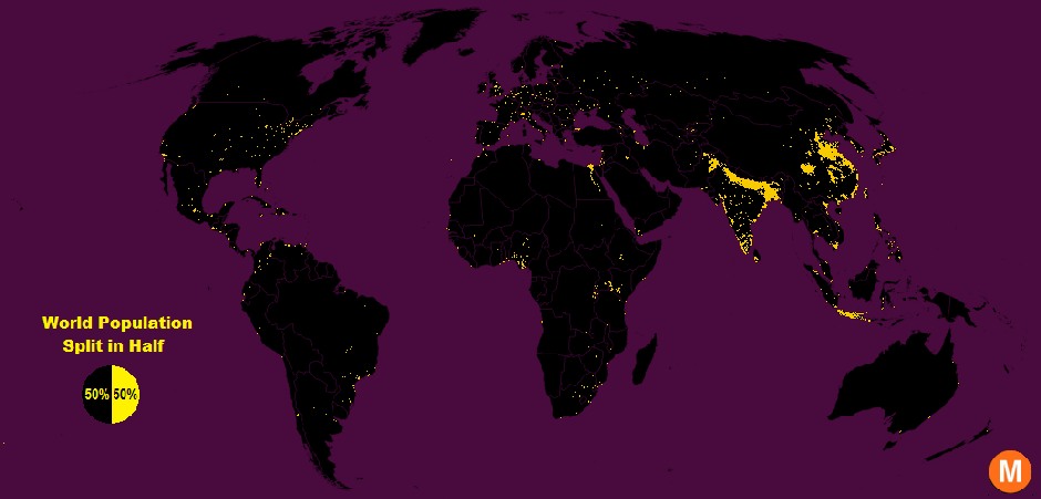
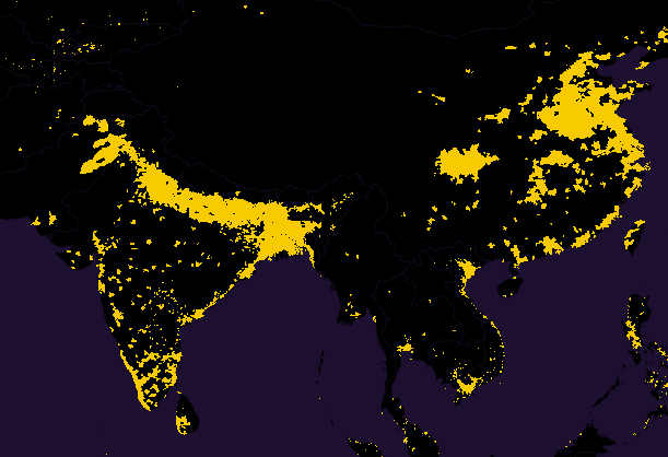
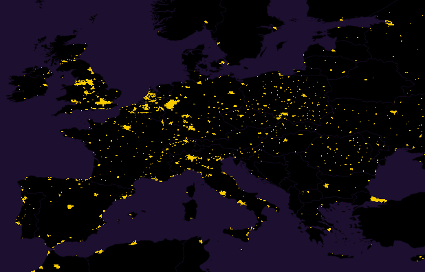
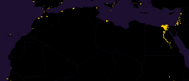
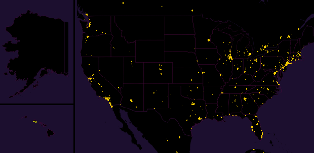
In the simple map above lies a stark spatial imbalance: half the people in the world cram into just 1 percent of the Earth’s surface (in yellow), and the other half sprawl across the remaining 99 percent (in black).
Data viz extraordinaire Max Galka created this map using NASA’s gridded population data, which counts the global population within each nine-square-mile patch of Earth, instead of within each each district, state, or country border. Out of the 28 million total cells, the ones with a population over 8,000 are colored in yellow. That means each yellow cell has a population density of about 900 people per square mile—“roughly the same population density as the state of Massachusetts,” Galka writes in the accompanying blog post. The black regions, meanwhile, reflect sparser population clusters.
Take this close-up of South and East Asia. The region in this image alone contains about 46 percent of the world’s population, which isn’t all that surprising considering India and China are the two most populous countries in the world.


Asia’s densest spots are mostly concentrated in the inland urban areas. Europe, on the other hand, is nowhere as dense as Asia but has its population hotspots sprinkled more uniformly across its area:


North Africa is almost entirely dark except for Cairo, which contains the yellow cell with the largest population in the world—a million people within the nine-square-mile sliver of land:


A lot of the population clusters in the U.S., as the close-up of the map below shows, are located in many Northeastern, Southern, and Western cities. Overall, the U.S. mirrors the world in the way its population is divided: one half packed in the small yellow regions, the other half spread out across a black expanse.


Friday, January 8, 2016

History's Biggest Tsunamis

Live Science Staff | March 11, 2011 08:34am ET


This is a natural color, 60-centimeter (2-foot) high-resolution QuickBird satellite image featuring the southwestern coast of Sri Lanka. Imagery was collected on December 26, 2004 at 10:20 a.m. local time, slightly less than four hours after the 6:28 a.m. (local Sri Lanka time) earthquake and shortly after the moment of tsunami impact.
Credit: Image Courtesy of Digital Globe


Some of the biggest, most destructive and deadliest tsunamis on record:

8,000 years ago: A volcano caused an avalanche in Sicily 8,000 years ago that crashed into the sea at 200 mph, triggering a devastating tsunami that spread across the entire Mediterranean Sea. There are no historical records of the event – only geological records – but scientists say the tsunami was taller than 10-story building.

Nov. 1, 1755: After a colossal earthquake destroyed Lisbon, Portugal and rocked much of Europe, people took refuge by boat. A tsunami ensued, as did great fires. Altogether, the event killed more than 60,000 people.

Aug. 27, 1883: Eruptions from the Krakatoa volcano fueled a tsunami that drowned 36,000 people in the Indonesian Islands of western Java and southern Sumatra. The strength of the waves pushed coral blocks as large as 600 tons onto the shore.

June 15, 1896: Waves as high as 100 feet (30 meters), spawned by an earthquake, swept the east coast of Japan. Some 27,000 people died.

April 1, 1946: The April Fools tsunami, triggered by an earthquake in Alaska, killed 159 people, mostly in Hawaii.

July 9, 1958:
Regarded as the largest recorded in modern times, the tsunami in Lituya Bay, Alaska was caused by a landslide triggered by an 8.3 magnitude earthquake. Waves reached a height of 1,720 feet (576 meters) in the bay, but because the area is relatively isolated and in a unique geologic setting the tsunami did not cause much damage elsewhere. It sank a single boat, killing two fishermen.

May 22, 1960: The largest recorded earthquake, magnitude 8.6 in Chile, created a tsunami that hit the Chilean coast within 15 minutes. The surge, up to 75 feet (25 meters) high, killed an estimated 1,500 people in Chile and Hawaii.

March 27, 1964: The Alaskan Good Friday earthquake, magnitude between 8.4, spawned a 201-foot (67-meter) tsunami in the Valdez Inlet. It traveled at over 400 mph, killing more than 120 people. Ten of the deaths occurred in Crescent City, in northern California, which saw waves as high as 20 feet (6.3 meters).

Aug. 23, 1976: A tsunami in the southwest Philippines killed 8,000 on the heels of an earthquake.

July 17, 1998: A magnitude 7.1 earthquake generated a tsunami in Papua New Guinea that quickly killed 2,200.

Dec. 26, 2004: A colossal earthquake with a magnitude between 9.1 and 9.3 shook Indonesia and killed an estimated 230,000 people, most due to the tsunami and the lack of aid afterward, coupled with deviating and unsanitary conditions. The quake was named the Sumatra-Andaman earthquake, and the tsunami has become known as the 2004 Indian Ocean tsunami. Those waves traveled the globe – as far as Nova Scotia and Peru.

March 11, 2011: A massive 8.9-magnitude earthquake struck northern Japan, triggering tsunamis that reportedly swept up cars, buildings and other debris. The Japan Meteorological Society has forecast more major tsunamis in the area, with some expected to reach more than 30 feet (10 m) off the coast of Hokkaido, Japan's second largest island. A tsunami was also generated off the coast of Hawaii, one that could cause damage along the coastlines of all islands in the state of Hawaii, according to the Pacific Tsunami Warning Center. Tsunami warnings are in effect across Hawaii as well.

Sources: NOAA, USGS, Humboldt State University

Wednesday, January 6, 2016

15 ways the world will be terrifying in 2050


Christina Sterbenz and Erin Brodwin
Business Insider
Jan. 1, 2016, 9:00 AM


AP

By mid-century, we'll likely have self-driving cars, more widespread internet access, and semi-smart robots.

But despite our technological advances, humanity has failed to solve many of its problems. The world hasn't weaned itself offfossil fuels or antibiotics,protected the rain forest, or reduced the stigma surrounding mental illness. We haven't flood-proofed our cities or protected our energy grids from natural disasters.

With 2050 just a few decades away, major issues await the world.

Science and technology need to start focusing on solutions to make the future better than the terrifying reality approaching:

The number of people living in cities will likely triple.

Flickr/Timmy Caldwell

In 1950, just under 750 million people lived in urban areas. Today, that figure has ballooned to more than 4 billion — more than half the world’s entire population — and the upward trend is set to continue. By mid-century, about 6.3 billion people will live in cities.


Aside from overcrowding, the skyrocketing population will likely spur the faster spread of infectious diseases and viruses, from tuberculosis to the flu. Dwindling water supplies and inadequate sanitation will only compound the negative health affects.

Compared to rural areas, cities consume about three-quarters of the world’s energy and produce the same amount of global carbon emissions. Therefore, a rise in the urban population will also put pressure on energy demands and generate more pollution, potentially making the air toxic to breathe, similar to the situation in Beijing unfolding over the last decade.


According to the World Health Organization, outdoor air pollution is estimated to have caused 3.7 million premature deaths worldwide in 2012. This will only increase as urban populations rise and pollution worsens.


The air could be thick with pollution, worsening lung conditions and respiratory diseases.

Getty Images

By 2050, the number of deaths caused by air pollution — which includes tiny particles found in smoke and haze, ground-level ozone typically emitted by cars, and toxic components in household products and building materials — will soar, killing more than 6 million people every year, according to a recent report from the Organisation for Economic Co-operation and Development (OECD).

Why? Because in addition to dirtier skies, warmer weather will speed up the chemical reactions that produce many pollutants.

One of those toxins is ground-level ozone, a chemical that irritates the delicate tissue lining the lungs and causes coughing, feelings of burning, wheezing, and shortness of breath when inhaled. Ozone often worsens respiratory conditions like asthma and emphysema.

In India, where the problem is especially bad, the OECD estimates that about 130 out of every 1 million people will die prematurely from exposure to ozone.


More than half of the world's population may not have adequate access to water.

Screenshot via Growing Blue

Today, 1.1 billion people lack access to water. And 2.5 billion people (36% of the world's population) live in regions of the world experiencing water stress. Twenty percent of the world's GDP is produced in these areas as well.

Already, water scarcity hounds 2.7 billion people — nearly 40% of the world's population — for at least one month every year, either because they don't have access to clean water or because they can't afford it, Water Footprint Network says. And 1 billion people, about one-sixth of the world's population, face daily shortages, according to the foundation.

By 2050, however, this number will likely increase. Nearly 2 billion people will live in countries, mostly in the Middle East and North Africa, with absolute water scarcity, according to the International Water Management Institute. And by 2050, MIT researchers say that 5 billion of the world's projected 9.7 billion people could live in water-stressed areas.

Aside from a lack of drinking water, populations in these areas might not have the means to irrigate their fields (threatening food supply) or for other domestic, industrial, and environmental purposes.

Currently, one-third of the world's rivers — groundwater for about 3 billion people — are going or gone, according to the World Preservation Foundation. With population growth and global warming, the situation will only worsen. The drying of lakes and rivers releases greenhouse gases, like carbon dioxide and methane, into the air, potentially exacerbating climate change.

Because of the water cycle, the world will also face more droughts, potentially making wildfires at least twice as destructive by 2050.


The types of fish we eat could become extinct.

Flickr via Google Images

Right now, 87% of the world's assessed fish stocks are classified as over-exploited or fully exploited.

If the world continues fishing at its current rate, all fish stocks could become extinct by 2050, according to a 2010 report from the environmental branch of the UN. To combat the problem, many organizations, including the UN and European Commission, have tried to impose catch limits on certain species.

We have no idea what kind of damage the loss of fish species could cause to ecosystems around the globe — or how the changes will affect humanity. About 3 billion people receive one-fifth of their protein consumption from fish, making it a more important source than beef. We even use a multitude of medicines made from marine species.

And then there's the money. Between 10% and 12% of people around the world rely on fisheries and aquaculture for their livelihood, contributing to about $129 billion in global exports, about half of which comes from developing countries. All in all, the oceans produce around $3 trillion worth of goods every year.

If we expect to stop the collapse, however, more than 20 million people employed in these industries need to leave and train for other work over the next 40 years.


Millions could be without food.

WFP

Every decade, a warmer planet will decrease the amount of food we're able to produce around the globe by 2%. In case that doesn't sound like a lot, it means that in the next 10 years, we'll lose 4,440,000 metric tons of food. One tonne weighs a little over 2,200 pounds.

Here's how the problem will progress as the world warms:

— First, crop pests and pathogens will spread to warmer, drier areas where they haven't been a problem before. The problem will be especially acute across Africa and South Asia, which also happens to be where much of the world's food is produced.

— Global yields of wheat, corn, and millet will drop — researchers estimate they'll plummet nearly 10% by 2050. As the amount of food we're producing drops, the demand will rise. A rapidly expanding population will add to the demand, pushing it up by about 14% by mid-century.

— In this high-demand scenario, the price of rice and corn will double.

— The lack of proper nutrition will affect children acutely, severely stunting development. Malnutrition is expected to "moderately" stunt the growth of an additional 3.6 million children worldwide and "severely" stunt the growth of another 3.9 million children across the globe, according to the WHO.


The rain forests could face total annihilation.

AP Photo/Andre Penner

Deforestation in Brazil. Habitat destruction is a major threat to animals and people.

Each year, we lose a huge chunk of rain forest, the same place we get many of our life-saving drugs, to deforestation, most of which is caused by logging and farming.

At this rate, between a third and nearly half of the rain forest will vanish by 2050, according toa report from the International Journal of Climatology.

As the trees, animals, and habitat disappear, so too will the source of cancer-fighting drugs like Taxol, which was originally isolated from Cowtail Pine seeds.


Superbugs could kill 10 million people each year.

NIH/NIAID

Right now, infections that no longer respond to the drugs we once used are killing 700,000 people a year. By 2050, that number is set to reach 10 million deaths each year.

The problem of antibiotic-resistant bacteria has been exacerbated by the fact that doctors and pharmacists across the globe give them out freely and farmers worldwide use them liberally on their crops and add them to animal feed, even when animals aren't sick.

Because of this liberal use, antibiotics have become ever present; almost anywhere, they can be found floating in the water and buried in the soil. Unless the demand for antibiotics drops or the regulations on using them are tightened, we are set to live in a world where millions of people die from infections that can no longer be treated.


Diseases will spread with ease.

REUTERS/Adam Dean

Worried about the growing number of malaria cases, people display a sign saying 'Help Us' in a road near Kundangon, Myanmar.

A gradually warming climate will expand the range of pests carrying deadly disease. People who are affected will have little immunity from the disease.

The result? Diseases that are deadlier than ever.

— Malaria: By 2030, an additional 60,000 people will die of malaria, according to the World Health Organization (WHO). In the past few years, mosquitoes carrying the disease (whichkilled 630,000 people last year) have already begun creeping up mountains to recently warmed, higher-altitude elevations, where they spread malaria to areas that had never been exposed to the disease.

— Dengue and yellow fever: Mosquitoes, which thrive in warmer climates, also carry diseases like dengue and yellow fever, which collectively kill more than 50,000 people each year. As temperatures rise, more and more areas around the globe will become increasingly hospitable to the pests. By 2050, 4.6 billion people will be at risk of dengue, according to WHO.

— Cholera: Cholera thrives in warmer temperatures. The disease kills between 100,000 and 130,000 people worldwide each year, almost entirely in areas where there is a lack of clean water. At one site in Bangladesh, cholera risk spiked in the months after the water temperature there warmed 9 degrees Fahrenheit.


The number of people living with dementia will likely triple.

Flickr/Studio Grafico EPICS

As people live longer, we'll be confronted with more and more so-called diseases of aging. Particularly troubling will be the ones we don't already know how to diagnose or treat, like dementia.

By 2050, the number of people around the world living with dementia is expected to triple, rising from 36 million people to a staggering 115 million people, according to a recent report from the World Health Organization.

More than half of those who currently suffer from dementia — whose symptoms can be severe enough to get in the way of daily life — live in low- and middle-income countries. By 2050, that number will likely rise to more than 70%.

The biggest obstacle to treating dementia in many low-income countries is early diagnosis. Programs to increase awareness of symptoms and provide medical attention are expensive; even in wealthy countries, only between one-fifth and half of all dementia cases are recognized in time for adequate treatment.


Hurricanes could become more frequent and more severe.

Getty Images/Spencer Platt

As bad as Hurricane Sandy was, it could be just a hint of the destruction to come. While our grandparents most likely lived through one storm of Sandy's scale, our grandchildren can expect to see at least 20 during their lifetime.

While climate change is best known for lifting sea levels and raising temperatures, it will alsomake storms far more intense. As the Earth heats up, more water vapor — the fuel for storms — will enter the atmosphere.

This combination could make hurricanes up to 300% more powerful by 2100, according to National Oceanic and Atmospheric Administration (NOAA) modeling studies.

As oceans get warmer and northern sea ice begins to melt, sea levels will rise too, which will increase the frequency of floods across the globe.


Rising water levels could flood major cities across the globe.

Getty Images/Afton Almaraz

Sea levels across the globe are set to rise by roughly a meter — a little over 3 feet — by 2100 if carbon emissions continue unchecked.

Without proper planning, coastal cities from New York City to Calcutta, India, will be devastated.

Rising waters will begin to take their toll before 2100, of course. If sea levels rise by just 1.5 feet (the level expected for many cities, including the New Jersey shore, by mid-century), many people will lose their homes. Cities will lose valuable assets.

A 2008 report from the OECD found that Calcutta will likely be the hardest-hit city in the world, with 14 million people and $2 trillion in assets exposed by 2070. New York City made the list, too, with 2.9 million people and $2.1 trillion in assets laid bare to storm surges.

The rising tide will be felt acutely in the US, where by 2050 most of the cities along the northeast coastline will likely see more than 30 days of flooding each year.


Large-scale blackouts could become commonplace.

Flickr/Several Seconds

Remember how Hurricane Sandy blacked out much of New York City? Those types of situations are about to get a whole lot more common.

Higher water levels, more powerful tropical storms, and increased energy use across the globe will lead to widespread power outages.

In the US, the effects will be worst in crowded, northeastern cities like New York and Philadelphia. By 2050, up to 50% more people there will likely be temporarily without power. From New Orleans to Connecticut, blackouts will increase dramatically.


If you want convenience, you'll have to forsake privacy.

YouTube/calloftreyarch

Cortana is a disembodied voice on WP8 based on the Halo character.

While private citizens have grown increasingly concerned about the use of drones and other technologies, data lies at the heart of the digital revolution. Continued growth will almost certainly require a greater level of transparency between people and devices — and that means less privacy.

"People who are thinking that you can control your own identity aren't thinking about the problem right," futurist John Smart told Business Insider.

Take the idea of digital twins, computer-based versions of our personalities that can make decisions and complete tasks in our stead. To use them effectively, privacy will have to take a back seat.

The Pew Research Internet Project surveyed 2,511 experts and internet builders last year. We broke out a few notable predictions:
"Big data equals big business. Those special interests will continue to block any effective public policy work to ensure security, liberty, and privacy online." —executive at an internet top-level domain-name operator
"We have never had ubiquitous surveillance before, much less a form of ubiquitous surveillance that emerges primarily from voluntary (if market-obscured) choices. Predicting how it shakes out is just fantasy." —John Wilbanks, chief commons officer for Sage Bionetworks
"Citizens will divide between those who prefer convenience and those who prefer privacy." —Niels Ole Finnemann, director of Netlab

On the legal side, police can already create fake social-media accounts to catch criminals. Privacy experts are also voicing concerns about body cameras and other tools.


Cyberattacks could increase, causing tangible damage to the world.

Kevork Djansezian/Reuters

A security guard stands at the entrance of United Artists theater during the premiere of the film "The Interview" in Los Angeles, December 11, 2014.

The events surrounding the 2014 release of Sony's movie "The Interview" made it undeniably clear that cyberattackers mean business. Even minor breaches, like that of the Lizard Squad against PlayStation on Christmas Day, have increased in frequency and strength.

By 2025, experts believe that "nations, rogue groups, and malicious individuals" will step up their hacking games, according to a report from the Pew Research Center and Elon University. Of the 1,642 experts surveyed, 61% predicted a major attack causing significant loss of life or property and costing tens of billions of dollars.

Today, countries or militaries that don't typically attack in two dimensions have started to venture into hacking territory. For example, the Islamic State group (also known as ISIS or ISIL) recently launched its "cybercalliphate," and Russia is rumored to support a state-sponsored hacker group.

These hacks could affect banks, businesses, and private data, but also do tangible damage to a world increasingly reliant on technology. An attack on a German steel mill in 2014 caused significant damage to its furnaces. The year before, the Stuxnet virus destroyed one-fifth of Iran's nuclear centrifuges.


Oil could become prohibitively expensive.
Cornell

With more people come more houses and more cars and therefore a greater demand on energy resources. According to a report from HSBC, if global energy use continues at its current rate, the world in 2050 will have:

— A 110% increase in oil demand, to more than 190 million barrels a day

— A doubling of total energy demand

— A doubling of carbon in the atmosphere, to more than 3.5 times the amount recommended to keep temperatures at a safe level

While the US shale boom diminished fear of "peak oil" — the point at which the world runs out of oil — extracting the oil and natural gas the world still has could become even more expensive. OPEC has already predicted oil prices could explode to $200 a barrel.

Pursuing other energy sources requires careful consideration, though. Coal, for example, is one of the world's dirtiest energy sources. At the current rate of use, we have only another 176 years' worth of with it, according to HSBC. Therefore, non-fossil fuels have to play a greater role.

To start, renewable energy could provide up to 80% of the US' needs.