Visitors

Saturday, July 29, 2017

This 99-Million-Year-Old Bird Coexisted With Dinosaurs


Smithsonian.com
Erin Blakemore
JUNE 8, 2017

The tiny bird is a big find for paleontologists

Tree resin trapped this baby bird 99 million years ago. (Lida Xing)

Ninety-nine million years ago, birds and dinosaurs ruled the earth. But what did those early birds look like? That’s been hard to prove—until now. Thanks to an amazing fossil find, a bird encased in Cretaceous-era amber from Malaysia is giving researchers a new look at a mysterious species of birds that existed during the time of the dinosaurs.


“It’s the first time we’ve seen a relatively complete individual in Burmese amber,” Ryan McKellar, curator of invertebrate paleontology at the Royal Saskatchewan Museum and co-author of a paper that describes it, tells Smithsonian.com.

And what an individual. Though it’s less than three inches long, the bird was preserved in stunning detail. Scientists scanned the specimen, then created a 3D reconstruction to learn more about the tiny bird. They describe their find in the journal Gondwana Research.

The 99-million-year-old bird’s complete head, neck, part of one wing, and both feet were preserved, along with much of its skin, which helped the team map out the feathers and how they were attached to the tiny bird’s body. Its feathers were more like dinosaurs’ than modern birds’.


This reconstruction shows the fierce little bird in action. (Cheung Chung Tat)

Don’t get your hopes up: Unlike in Jurassic Park, this Cretaceous-era animal won’t yield DNA that can be studied or cloned. “The DNA angle is pretty much dead at this point,” laughs McKellar. But the team hopes that clues from the keratin inside the feathers could help reveal what color the bird was during its brief life.

“These birds hatched on the ground and then made their way into trees” just days after birth, says McKellar. Once there, the spiky birds—armed with a full set of teeth and wings with claws—weren’t babied like their modern relatives. Rather, their parents would have gone AWOL, leaving them to learn for themselves. “They’re not like the fuzzy, helpless chicks you’d think of nowadays,” he says.

The hatchling may have been fierce, but it succumbed to a stream of tree resin a few weeks after being born. It’s the bird’s loss, but our gain: The team hopes that the detailed specimen will shed light into how its family—the now extinct Enantiornithes—evolved and eventually died out. That, in turn, could tell us more about how modern birds came to be. “Even a few snapshots like this really improve our understanding of what’s going on,” says McKellar.


Read more: http://www.smithsonianmag.com/smart-news/99-million-year-old-bird-coexisted-dinosaurs-180963615/#pllf92R27wtJyF6Y.99

Follow us: @SmithsonianMag on Twitter

Wednesday, July 26, 2017

The mysterious bend in the Hawaiian-Emperor chain


Phys.org
June 8, 2017


The Hawaiian-Emperor Chain is an example of a hotspot track - a trail of volcanic islands and seamounts created on a lithospheric plate as the plate slowly shifts over a spot of localized melting sourced by a jet of hot material rising from …more

The volcanic islands of Hawaii represent the youngest end of a 80 million years old and roughly 6,000 kilometres long mountain chain on the ground of the Pacific Ocean. The so-called Hawaiian-Emperor chain consisting of dozens of volcanoes is well known for its peculiar 60 degrees bend. The cause for this bend has been heavily debated for decades. One explanation is an abrupt change in the motion of the Pacific tectonic plate, the opposite model states southward drift of the mantle plume that has sourced the chain since its beginning 80 million years ago. Apparently both processes play an important role, shows a new study in Nature Communications, published by a group of scientists from the University of Oslo, German Research Centre for Geosciences GFZ Potsdam, and Utrecht University.

Many volcanic ocean islands are created by columnar shaped hot upwellings called mantle plumes that originate near the ~3000 km deep base of Earth's mantle. Mantle plumes are not much influenced by surface motions of the tectonic plates that slowly move over them. Hence, long linear chains of plume-sourced volcanoes that get older and older with increasing distance from active hotspots can be tracked for hundreds to thousands of kilometres. In the Hawaiian hotspot trail, the Hawaii islands are the youngest in the chain that stretches nearly 6,000 km to Detroit seamount in the northwest Pacific, where volcanism occurred about 80 million years ago. An unprecedented 60 degrees bend characterizes the Hawaiian-Emperor Chain, dividing it into the older Emperor Chain and the younger Hawaiian Chain. The bend has been dated to 47 Ma (Fig. 1).

"The ultimate cause for the formation of the Hawaiian-Emperor Bend (HEB) was a prominent change in the Pacific plate motion at 47 Ma", says the lead author of the new study, Trond Torsvik from the University of Oslo and visiting researcher at GFZ at the moment. The team affirms a hypothesis by the US-geophysicist Jason Morgan who proposed that already in the early 1970s. "But it is not that simple as it was suggested forty years ago", says Torsvik.

Jason Morgan was the first to use hotspots as a reference frame for global plate motions. In his model mantle plumes—which are manifested by hotspots at the surface—were considered fixed in the mantle, and the Hawaiian-Emperor Bend was attributed to a simple directional change of the Pacific plate motion (Fig. 1). But his plate model with fixed hotspots became challenged from the 1980s.

Simulating the Hawaiian-Emperor Bend explains that the bend was formed through changes both of the direction of the lithospheric plates and some motion of the hotspot beneath the plates. Credit: T. Torsvik et al. (GFZ)

"Since the late 1990s it has become clear that hotspots are not totally fixed", says GFZ´s Bernhard Steinberger, one of the co-authors of the paper. That is now generally accepted, he adds, and mantle flow models predict that the Hawaiian hotspot has drifted slowly to the south. "But some recent studies have argued that rapid southward motion of the hotspot before 47 Ma can explain the formation of the bend without requiring Pacific plate motion change", he says. "Such a scenario has become attractive because the geology of the plates surrounding the Pacific shows no clear evidence for a Pacific plate motion change."

The new study shows clearly why this simply does not work. It would require an unrealistically high rate of hotspot motion of about 42 cm/year which would be much faster than the average speed of tectonic plates. Moreover, this would imply that the Emperor Chain was created in just five million years and Detroit Seamount should only be 52 million years old (Fig. 2a). This prediction is obviously falsified by the recorded Detroit Seamount island ages of about 80 Ma (Fig. 1).

"Alternatively, a slower hotspot motion towards the WSW could explain both geometry and ages of the Emperor chain", says Steinberger. However, such a direction of motion is inconsistent with mantle convection models.

"Our paper is a good example of how very simple simulations of plate and hotspot kinematics can be used to explore which geodynamic scenarios for the formation of the Hawaiian-Emperor Bend are possible, and which ones are not", says Pavel Doubrovine from the University of Oslo, another co-author on the paper. "We cannot avoid the conclusion that the 60 degrees bend is predominantly caused by a directional change in the Pacific plate motion." Yet, some southward plume motion is required (blue line in Fig. 2b), otherwise the Hawaiian-Emperor Chain would be around 800 kilometres shorter.

"Explaining the geometry, length and age progression of the Hawaiian-Emperor Chain, requires both: the change in the direction of plate motion and the movement of the hotspot", states Torsvik. "If, after more than two decades of debating the end-member scenarios of plate motion change versus hotspot drift, geophysicists will be able to agree that neither of the two is satisfactory - then we can move forward and address a more interesting question: what actually drove the Pacific plate motion to change at about 47 million years ago?" Hopefully, it will not take further 40 years to get an answer to this, he adds.

Explore further: Scientists discover how world's biggest volcanoes formed

More information: Trond H. Torsvik et al, Pacific plate motion change caused the Hawaiian-Emperor Bend, Nature Communications (2017). DOI: 10.1038/ncomms15660

Thursday, July 20, 2017

Glaciers are melting so much they are changing the shape of the Earth's crust

Independent
Ian Johnston Environment Correspondent
@montaukian
Tuesday 30 May 2017

Nasa scientists discover existence of glacial waves, which move huge amounts of ice and water into the sea during periods of intense melting, by studying changes to the land surface
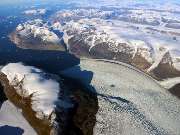
A meltwater lake can be seen on the Rink Glacier in western Greenland Nasa/OIB


Glaciers are melting so much that they are causing the Earth’s crust to change shape.

And now scientists have used this effect to discover an alarming new phenomenon that is speeding up the rate at which ice is pouring into the sea.

A team of Nasa scientists used measurements of “solid Earth deformation” to study the Rink Glacier in Greenland as it melted rapidly in the hot summers of 2010 and 2012.

What they found was that the “intense” melting of ice produced a ‘solitary wave’ in the glacier that pushed it more quickly towards the sea, which Nasa likened to a “warmed freezer pop[sicle] sliding out of its plastic casing”.

Writing in the journal Geophysical Research Letters, the scientists said “the wave through Rink Glacier is enormous in terms of its mass transport”.

Traveling at up to 12km per month, the 2012 wave alone was responsible for moving 6.7 billion tons of ice into the sea – compared to the average annual total of about 11 billion tons in the early 2000s.

The scientists, from Nasa’s Jet Propulsion Laboratory in Pasadena, California, said changes in the Earth’s crust had not been used before to assess glaciers.

The research represented a “breakthrough” because it showed how powerful this technique was but also because it had revealed the wave effect, they said.


Miles of Antarctic Ice are Collapsing into the Sea
“The technique is effectively using the measurement of the deformed solid Earth elastic response as a filter that uniquely responds to neighbouring glacier mass changes,” they said.

It is thought the wave began after meltwater cut channels through the glacier and drained down to the bottom.

In a statement, Nasa said the exact process was unclear, but the current theory to explain why the glacier “moved so quickly” went something like this: “The huge volume of water lubricated the base of the glacier, allowing it to move more rapidly, and softened the side margins where the flowing glacier meets rock or stationary ice.

“These changes allowed the ice to slide downstream so fast that ice farther inland couldn't keep up.”

One of the Nasa researchers, Dr Erik Ivins said solitary waves were likely to become a bigger factor in the future.

“Intense melting such as we saw in 2010 and 2012 is without precedent, but it represents the kind of behaviour that we might expect in the future in a warming climate,” he said.

“We're seeing an evolving system.”

10 photographs to show to anyone who doesn't believe in climate change


The changes in the Earth’s crust were monitoring by more than 50 GPS stations on the bedrock in Greenland.

These are not currently being maintained by any agency and the Nasa team were carrying out the research partly to see if there was any reason to keep them.

“Boy, did we find one,” Dr Ivins said.

Friday, July 14, 2017

If We Don't Act Soon, Space Junk Might Trap Us On Earth


Popular Mechanics
Sophie Weiner
Jun 11, 2017

The tiny pieces of junk orbiting the Earth could have a major impact on space exploration.


Not everything we send into space comes back down. In fact, there are millions of pieces of junk, ranging from tiny flecks of paint to entire satellites currently taking up space around the Earth's atmosphere. As of now, space agencies are already tracking 750,000 pieces of space debris orbiting the Earth. This space pollution is a major problem--because of how fast objects orbiting Earth travel, even a paint fleck a few millimeters long can cause serious damage when it hits something. The more that this space junk proliferates, the harder and harder it will be to send anything up into space. We could literally trap ourselves on Earth if we're not careful.

Luckily, scientists are working on ways to prevent this. One NASA program called Space Debris Elimination proposes shooting atmospheric gasses into space to destabilize the debris' orbit and send it plummeting back to Earth, where it will burn up in our atmosphere. Another proposal from the ESA tackles the larger pieces of debris, like old satellites. Their idea is to send a machine into space called the E-DeOrbit, which would literally shoot a net at old satellites and drag them back into the atmosphere with a small rocket. Neither of these solutions would address the millions of tiny bits of trash floating around the Earth, so the best idea for now is to prevent more from building up. If not, we could find ourselves trapped in a prison of our own making.


Source: Curious Droid

Wednesday, July 5, 2017

Climate change in B.C.: Here's how 2050 could look


More rain, longer heat waves and rising tides likely even if emissions are cut in half

By Tara Carman, CBC News
Posted: Jun 11, 2017


The risk of wildfires in the Okanagan will increase if average annual temperatures rise 2.5 C by 2050. (Jonathan Hayward/Canadian Press)

Tara Carman is an investigative journalist who specializes in finding the stories buried in big data. She has more than a decade of experience reporting in B.C., across Canada and overseas. She joined CBC News Vancouver in February 2017. You can reach her at tara.carman@cbc.ca or on Twitter @tarajcarman.


Climate change has been blamed for raging forest fires, devastating floods and shrinking glaciers, but scientists have determined the effects will look different in various regions of B.C.

Their severity depends on how successful humans are in reducing greenhouse gas emissions.

Under a middle-of-the-road scenario that assumes that in the future greenhouse gas emissions are halved, the average annual temperature in B.C. would increase by 2.5 C by 2050, according to the Pacific Climate Impacts Consortium.
Reporter's Notebook: A new perspective — crafting a climate change podcast
Listen to 2050: Degrees of Change, a CBC Vancouver podcast

This is more than the 2 C of warming climate scientists say represents a crucial tipping point — a scenario that forms the basis of the Paris climate agreement, which aims to limit global warming to less than 2 C above pre-industrial levels and closer to 1.5 C of warming.

In the Interior and the North, there would be even more variability, according to Trevor Murdock of the Pacific Climate Impacts Consortium, which is run out of the University of Victoria.

Here is a summary of what this could mean for B.C. and Metro Vancouver.


Warmer


2.5 C

Average annual temperature increase in B.C. by 2050

Rising Tides


30 cm

Projected sea-level rise in the Lower Mainland by 2050

Melting


25%

A quarter of B.C.'s glaciers will have melted by 2050

Cost


$32.7 billion

The projected cost of damage from flooding in the Lower Mainland

Wetter


10%

The wettest day of the year in 2050 will be 10 per cent wetter than the wettest day of the year now

Hotter


2X

By 2050, the number of days above 25C will roughly double in the Lower Mainland going from 18 a year, to more than 30.

Local experts in the field say it would look something like this:
Rising sea levels could erode sandy beaches, such as Jericho or Cates Park, especially during storms, said John Clague, an earth sciences professor at Simon Fraser University. Built structures, such as the Stanley Park seawall, would also take a beating during storms. Low-lying areas, such as Richmond and Delta, home to such critical infrastructure as the airport, the Tsawwassen Ferry Terminal and Deltaport, will be particularly vulnerable to flooding. It is therefore essential that the diking system is built to withstand such increases, Clague said.

Glacier loss of anywhere from 20 to 25 per cent would mean less cold water making its way into river systems, placing significant stress on species of fish, such as bull trout and salmon, that are sensitive to changes in temperature and aquatic ecosystems in general, said Brian Menounos, a professor of Earth Sciences and Geography at the University of Northern B.C.

The Fraser Basin Council predicts that by the year 2100 a Fraser River flood would cost $32.7 billion to the economy, including an estimated $7.7 billion in interrupted cargo shipments, $7.6 billion in commercial damages and $6.6 billion in residential damages.The risk of flooding increases over the next 85 years.

Metro Vancouver's wettest days are going to become about 10 per cent wetter, Murdock said, This raises the risk of mudslides and flash flooding.

The number of days above 25 C in Metro Vancouver would roughly double, from 18 now to more than 30 per year in 2050. The City of Vancouver is likely to have about 30 days above 25 C. More inland parts of the region would likely see more, Murdock said. While more hot days might seem a welcome change for some, this also means more heat waves, which can be hard on the elderly and a greater strain on cooling and air-conditioning infrastructure.

Other impacts could include a growing season in the Lower Mainland expanded by more than two months and a 30-per-cent drop in frost days in the Okanagan, meaning the winters won't be cold enough to keep pests away.

In the Interior, the fire season could increase anywhere from 30 to 50 days.

With files from Johanna Wagstaffe and Polly Leger.