Visitors

Tuesday, April 26, 2016

Here's a London Marathon pub map in case you didn't feel like running

Now this is my kind of marathon!

Helena Horton
22 APRIL 2016


Pub Map


Feel a bit left out of the London Marathon - but not left out enough to force yourself to run all that way?

You're in luck - There's A Beer For That has created a London Marathon pub map, with excellent pub choices from mile 1 right to the end of the race.

You can drink (responsibly, please) the whole way along the route, soaking up the spring sun while your virtuous, but sweaty, friends pant their way to the finish line.

At some of the pubs, you have a great vantage point to watch the race -and the many celebrities who are running.

The people behind the map have written a little description of each pub, as well as drink recommendations.

Mile 1
The Royal Standard Pub
Address: 44 Vanbrugh Park, London SE3 7JQ


To kick start the Marathon, try this elegant, yet cosy pub. Serving a great selection of beers, seasonal pub food and a friendly atmosphere, The Royal Standard is exactly what you're looking for.

What to drink: Take Courage Best Bitter. Pale in colour, fully balanced with a malty flavour and distinctive hop character, makes for an easy drinking beer.

Mile 2
The White Swan London
Address: 22 The Village, London SE7 8UD


A gastropub with good quality cask ales and cosy surroundings, The White Swan is the perfect place to enjoy a pint. It's also another excellent way to open the London Marathon should you wish to cheer on those running the second mile.

What to drink: Theakston Atlantic Red. The aroma is smoky with some spices. Expect malty, light and sweet flavours with a hint of sourness. Cheers to your runner!


Mile 3
The Dial Arch
Address: The Dial Arch Buildings, Major Draper Street, Royal Arsenal, Woolwich, London SE18 6GH


For a warm welcome and a fantastic drinks range including an extensive selection of cask ales, the beer garden at The Dial Arch is the perfect spot to cheer on your runner as they pass by!

What to drink:Young’s London Gold. Thisis a light, golden and full-flavoured ale with a refreshing bite. It's perfect with grilled marinated chicken or pasta if you hit the pub at lunchtime.

Mile 5
The White Horse Pub and B&B
Address: 704 Woolwich Rd, London SE7 8LQ


The White Horse has all the usual favourites at quality prices.

What to drink: Budweiser. This pale lager has a beautiful golden colour and rich head, its mild hop aroma balances well with its perfectly synchronised bittersweet taste.

Mile 7
The Cutty Sark
Address: 4 - 6 Ballast Quay, Greenwich SE10 9PD


Spread over three floors with stunning views of Canary Wharf and the O2, The Cutty Sark is a beautiful riverside pub serving great local beers.

What to drink: Camden Wheat Hefeweizen. Thisis the perfect choice to sit back and enjoy the Marathon. It's unfiltered and hazy, giving a beautiful aroma of banana, bubblegum and vanilla.
Tim Peake set to do the London Marathon...from spacePlay!02:18


Mile 11
The Mayflower
Address: 117 Rotherhithe St, London SE16 4NF


The Mayflower is oldest pub on the River Thames. It offers an incredible view of the River and is the perfect spot to relax and soak up the incredible atmosphere.

What to drink: Leffe Blond. This is a pale abbey beer, with a full, sunny, golden colour. It has a smooth and full-bodied taste and a rich, creamy head. Like all the Leffe beers, it is a ’connoisseur’ beer that is easy to drink.

Mile 12
The Bridge House
Address: 218 Tower Bridge Rd, London SE1 2UP


The Bridge House is located in Tower Bridge. If it's cold outside, keep warm by the fire, while if the weather is warm you can enjoy a drink outside and support the efforts of your runner half-way through their journey!

What to drink: Adnams Dry Hopped Lager.This golden lager is light, crisp and refreshing with subtle malty flavours and a super hoppy aroma of tropical fruits, citrus and passion fruit.

Mile 17
The George Pub
Address: 114 Glengall Grove, London E14 3ND

For an excellent range of beers, a glassed garden area and a lovely atmosphere - this traditional East End pub is an ideal place to have something refreshing on the 17th Mile of the Marathon.

What to drink: Timothy Taylor Landlord.This is a strong, classic ale with a golden amber colour. It has a scent of caramel, light fruits and roasted malt hints.
Eddie Izzard attempts 27 marathons in 27 daysPlay!01:37


Mile 18
The Henry Addington
Address: 22-28 Mackenzie Walk, London E14 4PH


When it's time to get competitive, head for The Henry Addington. In their historic surroundings, laughter and conversation flow freely. You are also welcome to sit outside to see your favourite runners passing on their last miles.

What to drink: Siren Liquid Mistress. This west coast bright red ale has notes of burnt raisins and crackers balanced by citrus.

Mile 23
Fuller's The Banker
Address: Cousin Lane, London EC4R 3TE


The waterside setting of this pub makes it truly irresistible in summer, with amazing views of the River Thames and beyond. Cheer on your runner and sit FROW whilst enjoying a refreshment atThe Banker.

What to drink: Fuller's Front Row. Pale amber with a subtle floral aroma, Front Row scores with a malty, biscuit character reminiscent of London Pride. Beautifully balanced by flowery hops, the grassy flavours create a satisfying finish.

Mile 24
The Blackfriar
Address: 174 Queen Victoria St, London EC4V 4EG


The Blackfriar is reputed for its distinctive building, intriguing history and vibrant atmosphere.

What to drink:Sambrook's London Pale.This pale ale is light, dry and has a zesty tate with a citrus aroma.

Mile 25
Walkers of Whitehall
Address: 15 Whitehall, London SW1A 2DD


This distinguished pub is perfect to indulge in a beer as you track your runner conquering their last two miles.

What to drink:Heineken. Made with 100% barley malt, choice hops and pure water this brew achieves unsurpassed clarity.

Finish Line
Buckingham Arms
Address: 62 Petty France, London SW1H 9EU


A quirky, friendly and welcoming haven in the hustle and bustle of central London is the perfect spot to see your runner cross the finish line. Raise a bottle of Fuller's London Pride in celebration!What to drink: London Pride. This is a smooth and astonishingly complex beer, which has a distinctive malty base complemented by a rich balance of well developed hop flavours.

Monday, April 25, 2016

This Old Map: Da Vinci's City Plan, 1502

LAURA BLISS  @mslaurabliss
CITYLAB
Apr 22, 2016
Leonardo da Vinci, “Town plan of Imola,” 1502. (Public domain via Wikimedia Commons)

Perhaps the most common type of city map is the kind on Google Maps: a flattened out, “ichnographic” plan, where all buildings and features appear perfectly perpendicular to a single, aerial viewpoint. This unrealistic view allows newcomers to grasp a city’s entire layout, relative to its environs and the cardinal directions. In the era of GPS and aerial photography, creating an accurate ichnographic plan isn’t too difficult. But one such map, created by a famous Renaissance polymath, pre-dated airplanes and satellites by centuries.

Who made this map?

The mapmaker in question is Leonardo da Vinci (as if we needed another reason to appreciate him). He made this map of the Italian town of Imola toward the end of his life—after creating The Vitruvian Man, but before his most famous masterpiece, The Mona Lisa.

In 1502, da Vinci entered into the patronage of Cesare Borgia, a general and statesman whose hunger for power served as inspiration for Machiavelli’s The Prince. Borgia’s forces had already overtaken the city of Imola in 1499, but the Roman-born conqueror “probably did not have a very good grasp of the geography of the city he now governed and defended,” according to Phaidon, the publisher of Map: Exploring the World, a book that details da Vinci’s cartography and many others. Da Vinci mapped Imola in order to help Borgia get acquainted.

Why was it important?

A map made by da Vinci would be interesting even if he hadn’t applied his fabled genius to the task. But here, he absolutely did. Besides this being a beautiful map, with its delicate colors and washes, it achieves a technical precision few others did at the time.

Most Renaissance maps are known for their fanciful inclusion of dragons, castles, and undulating mountainsides, and most of them show buildings in elevation, or the “oblique perspective.” But da Vinci’s sought to capture the proportions and relationships between land features more accurately, and he developed new technologies to do so. To make this map of Imola, he may have used the special hodometer and magnetic compass he’d already invented (he’d been fascinated by maps and optics for years). With careful measurements in hand, he drew every “street, plot of land, church, colonnade, gate and square, the whole encompassed by the moat,” writes the Renaissance historian Paul Strathern.

Da Vinci centered the plan in a circle with four crossing lines, representing the points on a compass. And he showed the city ichnographically, “as if viewed from an infinite number of viewpoints,” perhaps inspired by his study of avian flight. It is the earliest such map in existence.

But is it really that accurate?

Well, not 100 percent. Da Vinci was a stickler for aesthetics. Based on comparisons to da Vinci’s own earlier sketches and actual details of the city,scholars say that he did occasionally privilege beauty over exactness in this portrayal of Imola. But in this way, too, he was ahead of his time. “Even as similitude became a touchstone for evaluating maps, cartographers manipulated their creations to serve aesthetic principles,” writes Genevieve Carlton in Worldly Consumers: The Demand for Maps in Renaissance Italy.That’s still very much the case; Google Maps, after all, is hardly perfect when it comes to scale.

Thursday, April 14, 2016

Photographer captures moment Icelandic volcano erupts, in pictures


The Telegraph
11 April 2016


A photographer has captured the moment a group of friends stood on the rim of an erupting volcano. Photographer Johannes Gunnar, 25, from Reykjavik, Iceland, took these images on Fimmvörðuháls volcano- showing just how close the spectators were to the dazzling display.
CREDIT: JOHANNES GUNNAR/CATERS NEWS


While molten rock raining down made for an incredible scene, Johannes admitted that he had a couple of close calls while shooting the eruption. At one point, while taking photos, Johannes was nearly hit by a piece of molten rock, which would have killed him instantly.
CREDIT: JOHANNES GUNNAR/CATERS NEWS


While the surrounding area was a brisk -10C, Johannes and his brave mates in the photos could feel the heat of the eruption radiating off it and as well as taking off their jackets, they were able to cook hot dogs and marshmallows.
CREDIT: JOHANNES GUNNAR/CATERS NEWS


Johannes said: "The eruption was like something I have never seen before - it was beautiful, but deadly. At one point, molten rock landed only a metre away from where I was stood which prompted me to pull back a little."
CREDIT: JOHANNES GUNNAR/CATERS NEWS


A column of ash and gas rises into the sky
CREDIT: JOHANNES GUNNAR/CATERS NEW


"It was unbelievably hot on the rim of the crater. We all had to take our jackets off and some of the guys were even cooking hotdogs."
CREDIT: JOHANNES GUNNAR/CATERS NEWS


A lump of cooling molten rock
CREDIT: JOHANNES GUNNAR/CATERS NEWS


"When the glacier's volcano started to erupt, to experience it first hand was just a no-brainer for me. I love nature and wanted to capture what was going on."
CREDIT: JOHANNES GUNNAR/CATERS NEWS


A column of ash and gas rises into the sky
CREDIT: JOHANNES GUNNAR/CATERS NEWS


"Skarpi and Gunnar, my friends, stood in front of thevolcano as silhouettes. They were extremely brave doing that, as it was very hot on the crater."
CREDIT: JOHANNES GUNNAR/CATERS NEWS


On 20 March 2010, an eruption of the Eyjafjallajökull volcano began in Fimmvörðuháls following months of small earthquakes under the Eyjafjallajökull glacier.
CREDIT: JOHANNES GUNNAR/CATERS NEWS


A lump of cooling molten rock
CREDIT: JOHANNES GUNNAR/CATERS NEWS

Wednesday, April 13, 2016

Magnificent Mount St. Helens Photos For Your Viewing Pleasure

Dana Hunter 
Scientific American
April 10, 2016

I'm still going through the USGS image database for Mount St. Helens. It's going to take me a while - there are almost two thousand images to sort, catalog, and save.

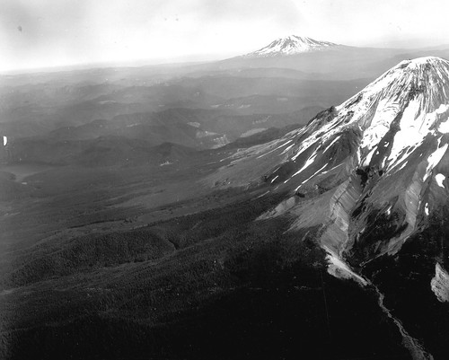
Really magnificent pre-eruption photo of Mount St. Helens. Definitely enlarge this. You'll see some fabulous glacial geology, inverted topography, old lava domes, and Mount Adams. Drooling now. 


PRE-ERUPTION AERIAL VIEW NORTHEASTWARD OF MOUNT ST. HELENS IN THE FOREGROUND, MOUNT RAINER IN BACKGROUND. IMAGE AND CAPTION COURTESY USGS.

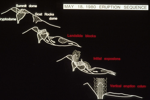
Here's a nice visual explanation of the May 18th eruption.


SIMPLE DIAGRAM BY J.G. MOORE SHOWING MOUNT ST. HELENS ERUPTION SEQUENCE OF MAY 18, 1980. SKAMANIA, COUNTY, WASHINGTON. IMAGE AND CAPTION COURTESY USGS.

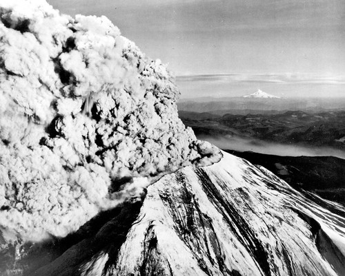
For my Oregon peeps: Mount St. Helens in eruption, with Mount Hood in the background.


MOUNT ST. HELENS IN ERUPTION, LOOKING TOWARD THE SOUTHEAST ON MAY 18, 1980, WITH SNOW-COVERED MOUNT HOOD ON THE DISTANT HORIZON. SKAMANIA COUNTY, WASHINGTON.

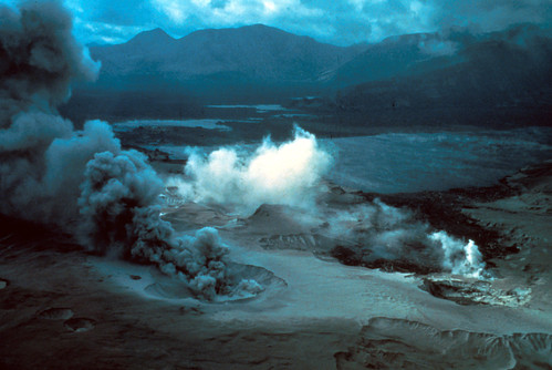
Eerie photo taken right after the May 18th eruption. We're looking across Spirit Lake. In the foreground, steam bursts from fumaroles in the blast deposits.


OBLIQUE AERIAL VIEW ACROSS SPIRIT LAKE AFTER THE ERUPTION OF MOUNT ST. HELENS; SECONDARY STEAM FUMAROLES IN BLAST AREA IN FOREGROUND. SKAMANIA COUNTY, WASHINGTON. 1980. IMAGE AND CAPTION COURTESY USGS.

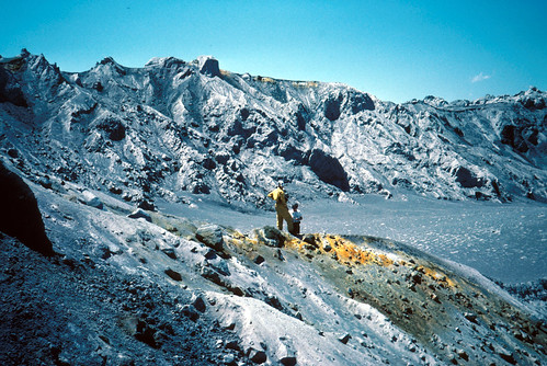
Absolutely gorgeous image of fumaroles on a pyroclastic flow from May 18 1980.


FUMAROLES ON PYROCLASTIC FLOW OF MAY 18 ERUPTION OF MOUNT ST. HELENS. SKAMANIA COUNTY, WASHINGTON. JUNE 1, 1980.

This is a rather gorgeous fumarole on a pyroclastic deposit from the May 18 eruption, with geologists for scale. You know, catastrophic destruction makes for magnificent landscapes.


FUMAROLES AND GEOLOGISTS ON PYROCLASTIC FLOW OF MAY 18 ERUPTION OF MOUNT ST. HELENS. SKAMANIA COUNTY, WASHINGTON. JULY 1, 1980. IMAGE AND CAPTION COURTESY USGS.

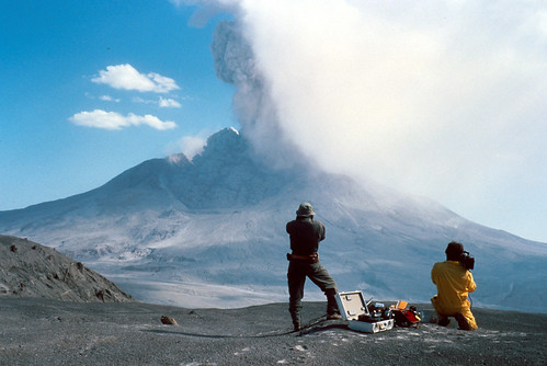
Geologists watching the August 7th, 1980 eruption. Dunno about you, but I'd have to spend a lot of time and effort screwing my courage to the sticking-place before I'd be able to stand there filming the volcano going boom after what it did in May.


TIME LAPSE OF AUGUST 7, 1980, ERUPTION OF MOUNT ST. HELENS. GEOLOGIST IN FOREGROUND FOR SCALE. SKAMANIA COUNTY, WASHINGTON. IMAGE AND CAPTION COURTESY USGS.

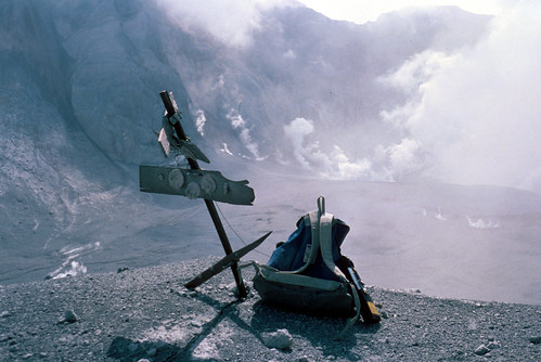
Eruptions are quite rough on volcano monitoring equipment. This is Kid Valley geodetic target after the eruption above got through with it.


KID VALLEY GEODETIC TARGET AFTER AUGUST 7 ERUPTION OF MOUNT ST. HELENS. SKAMANIA COUNTY, WASHINGTON. AUGUST 9, 1980. IMAGE AND CAPTION COURTESY USGS.

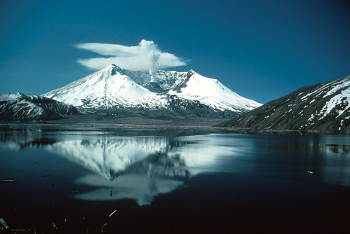
Here's a really lovely image from May 19th, 1982. You can see that Mount St. Helens hasn't quite gone back to sleep yet. Photo is by Lyn Topinka, who has taken many marvelous pictures of that volcano. You'll see more of her work as we go along.


MOUNT ST. HELENS REFLECTED IN SPIRIT LAKE, TWO YEARS AFTER THE ERUPTION OF MAY 18, 1980. SKAMANIA COUNTY, WASHINGTON. MAY 19, 1982. PHOTOGRAPH BY LYN TOPINKA. IMAGE AND CAPTION COURTESY USGS.

I'll have more lovely photos from before, during, and after May 18th, 1980. I've also got some non-volcanic adventures planned for this month. We're going to be venturing into geology quite different from the young stuff around Western Washington. Stay tuned!

Tuesday, April 12, 2016

Interesting Map of the Ancient Courses of the Mississippi


Maps on the Web
April 10, 2016

interesting-maps:

Map of the ancient courses of the Mississippi River Valley prepared by Harold Fisk of LSU, 1944.


Map of the ancient courses of the Mississippi River Valley prepared by Harold Fisk of LSU, 1944.


Monday, April 11, 2016

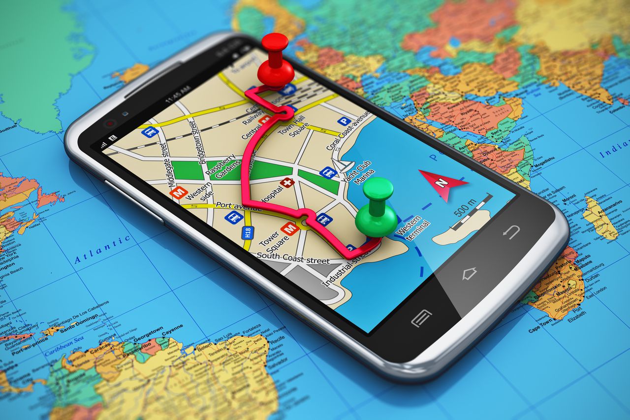
Have we become too reliant on GPS? This satellite expert thinks so.

Vox Technology


Brad Plumer 
April 10, 2016

Ruling our world.(Oleksiy Mark/Shutterstock)


In 2008, a Syrian truck driver was faithfully following his satellite navigation system and ended up 1,600 miles away from where he was supposed to be. He'd meant to go to Gibraltar, off the south coast of Spain. He arrived at Gibraltar Point, England, surrounded by a group of befuddled birdwatchers.

That's a pretty extreme blunder. But stories like this have gotten satellite expert Roger McKinlay thinking about whether we've become too dependent on GPS and other satellite navigation devices — particularly now that so many adults rely on their smartphones rather than their brains to get around unfamiliar territory.

For starters, these devices don't always work as well as we think they do, and can fail in surprising ways. That could become an even bigger problem as we push for driverless cars and other self-navigating vehicles. Worse, our reliance on GPS might be causing our innate navigational capabilities to atrophy over time, leaving us helpless when technology fails and we're forced to orient ourselves. "We've become overdependent," McKinlay says.

McKinlay, the former president of the Royal Institute of Navigation, recently wrote anessay for the journal Nature on how "automatic wayfinding is eroding [our] natural abilities." Curious, I called him up to talk more about the pitfalls of relying on GPS, what it's doing to our brains, and whether there are better alternatives.
Satellite navigation doesn't always work as well as we like to think

For most of us, 99.9 percent of the time, GPS works incredibly well. The Google Maps app on our smartphones gets us to where we need to go, and we don't think twice about it. But McKinlay is interested in those times that it fails. Because satellite navigation can go awry in rather unexpected ways.

The Global Positioning System (GPS) consists of 31 satellites orbiting Earth from 12,550 miles up, transmitting signals as they go. They were originally put up there by the Department of Defense to aid with military navigation, but can now be accessed freely by anyone in the world with a GPS receiver in their car or phone. The receiver just needs to pick up at least four signals to trilaterate your position.(GPS.gov)The current configuration of GPS satellites orbiting the Earth.

There are a few kinks in this set-up, however. For one, McKinlay notes, signals from these satellites are relatively faint, and can be bounced around by buildings or other structures, messing up the information gathered by GPS receivers. This is particularly a problem for downtown areas. "There are plenty of cases of drivers in built-up urban areas suddenly wishing they had a map," he says. (By the same token, GPS hardly works at all indoors — in those cases, your smartphone instead tries to pick up nearby WiFi signals to "guess" where you are.)


Unreliable signals could become a much bigger issue if we try to fill the roads with self-driving cars, which are likely to rely heavily on GPS. After all, autonomous vehicles can't just work 99 percent of the time. They have to work 100 percent of the time. It's not okay for a driverless car to get bewildered for a bit because it's in a city center.

A second problem: devices that intentionally disrupt GPS are becoming more common, which is potentially a major danger for ships and planes.

"Back in 2009, engineers were testing a GPS system at Newark airport and kept encountering regular interference," McKinlay says. "They finally figured out, through closed-circuit cameras, that it was a passing truck driver who was using a GPS jammer so that his employer couldn't track him. There are also cases of criminals using jammers — which are handy for stealing cars — around ports, which can affect maritime navigation. This still isn't common, but it's being observed more often."

The US Coast Guard is increasingly worried about the effect of signal-jamming on ships, which are heavily dependent on satellite navigation. Officials have claimed that a East Coast US port (they didn't say which one) was paralyzed for seven hours in 2014 as a result of signal interference.

(Shutterstock)Doesn't respond well to jamming.

To be fair, countries are hard at work trying to fix these problems. Various US agencieshave already augmented GPS with air- and ground-based systems such as WAAS and NDGPS to improve signal accuracy. Meanwhile, Europe is launching a network of 30 satellites, known as Galileo, to complement GPS. China is building up its own BeiDou system. These additional systems should bolster coverage, though they also cost a lot of money. (The US has invested over $10 billion into GPS to date, and spends about $1 billion a year to maintain the service.)

Combating jammers is a tougher challenge, and will either involve further ground-based augmentation or, in some cases, resorting to new technology. The Department of Defense is looking into eLORAN, a system that would complement GPS by sending unjammable signals from ground-based stations.

But even these fixes still leave another key problem with satellite-navigation systems: they'll only ever be as "smart" as the humans who direct them. The GPS that took the Syrian truck driver to Gibraltar Point instead of Gibraltar wasn't confused — the human was. And that's where McKinlay is particularly worried. Because in our growing reliance on GPS, we might well be losing basic navigation skills.

GPS may be ruining our ability to navigate for ourselves

(Shutterstock)What on earth are those squiggly lines?

Our brains have a pretty outstanding capacity for figuring out how to get around. London cab drivers manage to memorize more than 25,000 streets and can rapidly figure out the best way to get from Point A to Point B. Marshall Islanders can famously navigate vast tracts of open ocean without any instruments at all.

Neuroscientists have discovered that our brains have two different specialized systems for navigation. In one system, located in our hippocampus, we create spatial maps of the world around us, understanding how different streets and routes fit together. In the second, located in the caudate nucleus, we make a mental list of the different landmarks we encounter every day. Left out of the driveway. Right at the grocery store. Etc.

These systems can get better over time with practice. London cab drivers who acquire "The Knowledge" of the city's mind-boggling street network have been shown to have significantly larger hippocampi than the rest of us.

But conversely, as Joseph Stromberg has explained, there's some evidence that these systems can erode if they're not used. When we stop trying to figure out routes for ourselves and instead rely solely on the turn-by-turn directions of our GPS, our ability to work out spatial maps seems to get worse. "One Japanese study," Stromberg wrote, "found that compared with people who were given paper maps and figured out routes for themselves, GPS users later drew maps with less detail and accuracy."

McKinlay frets that this could lead to problems. Lack of navigational skills is how a Belgian bus driver could take 50 tourists 800 miles in the wrong direction because he punched in the wrong address on his GPS device. It means that when our mapping devices stumble, we're completely powerless. "You see increasing stories about people going hiking with their smartphones as their only guide," he says. "Then their phone dies and they're incapable of navigating for themselves" and have to be rescued.

"We think about the world around us completely differently if we've sat down with a map and thought about the best route before the trip," McKinlay argues. "It's way too optimistic to think we can just hand that task entirely over to our smartphone and it will be the same thing." (A grim example was this man in Spain who died after driving his car into a reservoir because his GPS didn't realize it was taking him down a defunct road.)

Even beyond navigational snafus, other researchers have wondered if our dependency on GPS is causing us to pay more attention to screens and lose connection to the world around us. "Instead of experiencing physical locations, you end up with a more abstract representation of the world," Cornell's Gilly Leshed told the Walrus.

As a remedy, McKinlay argues that schools should teach students map-reading and navigation as a critical life skill. He also suggests that researchers start looking at whether there are ways to design GPS systems so that they help us learn about our environment rather than making us unaware of the world around us. (It's unclear what exactly this would look like, but what if, as a default, these systems always walked us through the spatial map of where we were going? No doubt scientists would have to test whether this bolstered our navigational abilities.)

"Navigation is a real skill we have, it's something very fundamental and something we’re really really good at," McKinlay argues. "And we should be thinking about how to augment those skills with computers — not just trying to overwrite them."

Wednesday, April 6, 2016

The most dangerous volcanoes on Earth


By Nicole Dossantos
Fox News Travvel
Published March 31, 2016


Shutterstock

Volcanic activity is a harsh reminder that the world we live in is ever-changing and destructive. Volcanoes are mountains that open downward into a pool of molten rock below earth's surface. When pressure builds, eruptions and disaster occur.

As National Geographic explains, a large eruption can be extremely dangerous for people living near a volcano. Flows of searing lava, which can reach 2,000 degrees Fahrenheit (1,250 degrees Celsius) or more, can be released, burning everything in its path, including whole towns. Orange bursts into the sky, rocks shoot up, and lava rolls down the mountain during a dangerous eruption.

Volcanoes can cause flash floods, tsunamis, mudflows, rockfalls, and earthquakes. Indonesia has become the location of some of the most deadly eruptions. Tens of thousands of lives have been lost to ash flows, mudflows, and tsunamis. More than 80% of the earth's surface is volcanic in origin. The sea floor and some mountains were formed by countless volcanic eruptions. Gaseous emissions from volcano formed the earth's atmosphere (dosomething.org).

According to National Geographic, about 1,900 volcanoes on Earth are considered active, meaning they show some level of activity and are likely to explode again. Many other volcanoes are dormant, showing no current signs of exploding but likely to become active at some point in the future.


1. Yellowstone National Park, USA


Shutterstock

Yellowstone National Park is an active supervolcano. Yes, the majority of the park is a volcano. There have been at least three eruptions, 2.1 million years ago, 1.2 million years ago and 640,000 years ago. The most recent eruption collapsed and created a giant crater.

2. Mt. Aso, Japan


Shutterstock

The Aso volcano is one of the world’s most active. According to Volcano Discovery, “3 people were killed and 11 injured by ballistic blocks ejected by an explosion that occurred at about 1pm local time on 6 September 1979.” They also explain, “2 tourists were killed by volcanic gas 100m south of the rim of Crater 1 on 23 November 1997. Since 1980, more than 70 people have been injured by volcanic gases at Aso.”

3. Mt. Merapi, Indonesia


Shutterstock

Erupting approximately every 5-10 years, Mt. Merapi is Indonesia’s most active volcano. Several of these eruptions have ended in death and you can almost always see smoke emerging from the mountaintop. In 2010, the Indonesian government warned nearby villagers to move to safer grounds. About 19,000 people were affected.

4. Mt.Vesuvius, Italy


Shutterstock


Mt. Vesuvius is located in Italy and is the only active volcano in mainland Europe. It is most famous for its historic eruption in 79 AD, which destroyed the cities of Pompeii and Herculaneum. In the last 17,000 years, Mt. Vesuvius has experienced eight major eruptions and approximately 16,000 people have been killed.

5. Mayon, Philippines


Shutterstock

The Mayon volcano is frequently erupting. It produces extreme lava flows that travel far down the flanks. Frequent eruptions produce mud flows and ash falls that require all residents to evacuate. Lowland areas have been destroyed by eruptions.