Visitors

Tuesday, April 5, 2016

A Mistake in Google Maps Led a Demolition Crew to the Wrong House

By JAY BENNETT
MAR 25, 2016
Esquire

The owner planned on repairing the home, which was damaged by a tornado, but now it is completely demolished.


A tornado damaged neighborhoods in Rowlett, Texas, outside of Dallas in December, but unfortunately for one family, that wasn't then end of the destruction. After a mistake in Google Maps led a construction crew to the wrong house, Lindsey Diaz's home was demolished as she was in the process of applying for a builder's permit to repair the damage caused by the tornado.


The demolition company, Billy L. Nabors Demolition, has blamed the mishap on Google Maps. The house that was supposed to be demolished is 7601 Cousteau Dr., but when you punch that into Google Maps, sure enough, it points to 7601 Calypso Dr., Diaz's house. Cousteau Dr. does wrap around and run adjacent to the mistakenly demolished house, but other GPS services, such as Mapquest, point to the correct house.


The mistake stands as a tragic reminder that will still can't rely wholly on the technology that makes our lives more convenient.

Source: WFAA via Engadget
From: Popular Mechanics

Monday, April 4, 2016

Maps Show Where Tourists Go - And Where Locals Do


Great Resource from National Geographic


If you want to find tourists snapping pictures, you probably know where to go—Times Square in New York City, the Embarcadero in San Francisco, or Chicago’s Magnificent Mile. But what locals think is picture-worthy in these cities is often substantially different. (Washington Post)

Use our resources to better understand urban geography.

Teachers, scroll down for a quick list of key resources in our Teachers’ Toolkit.

Discussion Ideas

Take a look at some maps of global tourist destinations. (Note there are two pages!) Red indicates photos taken by tourists. Blue indicates photos taken by locals. (So dark purple areas indicate heavy overlap between tourists and locals.) Yellow indicates photos that could have been taken by either a resident or a tourist.

Where do you think tourists are taking pictures in these cities?


Washington, D.C.
Map by Eric Fischer, courtesy Flickr. CC-BY-SA-2.0

That lovely red rectangle corresponds almost exactly to the National Mall, with the Lincoln Memorial to the west end and the U.S. Capitol to the east. In between, the Mall is lined by the National Gallery of Art and museums of the Smithsonian Institution. The red rectangle darting northward roughly corresponds to the White House, while the trefoil-shaped path to the south is the Tidal Basin, home of the Jefferson Memorial (and cherry blossoms!).


Paris, France
Map by Eric Fischer, courtesy Flickr. CC-BY-SA-2.0

The red areas in downtown Paris include Notre Dame Cathedral (one of the more southeasterly red blobs), and the long red line known as the “Axe Historique,” which includes the Louvre Museum, the Tuileries gardens, theArc de Triomphe, the Champs Elysees, and the big modern arch at La Defense. The red blob to the north probably represents visitors at the beautiful Sacre Coeur basilica. The island of tourism to the southwest probably indicates visitors at the Versailles palace complex.


Chicago, Illinois
Map by Eric Fischer, courtesy Flickr. CC-BY-SA-2.0

The red line running along Michigan Avenue is Chicago’s famous “Magnificent Mile,” which is part of the city’s “Loop” business district. The Magnificent Mile includes elite retail shops, hotels, and five of the 85 tallest buildings in the world. Jutting into Lake Michigan is the tourist-friendly Navy Pier.


Amsterdam, Netherlands
Map by Eric Fischer, courtesy Flickr. CC-BY-SA-2.0

Tourist-red almost exactly outlines Amsterdam’s U-shaped series of canals. Between the canals are the Rijksmuseum, the Anne Frank House, theMaritime Museum, and the city’s famous “red light” district. The island of tourism to the west of the city is probably the nearby town of Haarlem, famous for its tulip fields.


Orlando, Florida
Map by Eric Fischer, courtesy Flickr. CC-BY-SA-2.0

Orlando is the home of some of the world’s biggest theme parks. That’s Universal Studios Orlando to the north, Sea World due south of Universal, and the Disney complex to the southwest: the Magic Kingdom, Epcot (with the circle), Disney’sHollywood Studios, and Disney’s Animal Kingdom.

Now click through the cities in this gallery. What do they have in common? Why?

Las Vegas, Nevada
Map by Eric Fischer, courtesy Flickr. CC-BY-SA-2.0


Rome, Italy
Map by Eric Fischer, courtesy Flickr. CC-BY-SA-2.0


Istanbul, Turkey
Map by Eric Fischer, courtesy Flickr. CC-BY-SA-2.0

Jerusalem, Israel
Map by Eric Fischer, courtesy Flickr. CC-BY-SA-2.0

Cairo, Egypt
Map by Eric Fischer, courtesy Flickr. CC-BY-SA-2.0

All these cities seem to have no locals taking photos!

The absence of local photos might be due to the fact that these are urban areas with highly concentrated business districts. Most residents would likely be working downtown, with little time or inclination to snap photos.
The cartographer gathered his information solely from geotagged Flickr images. There is a good chance that many local residents are simply not uploading their everyday personal or family photos to Flickr.


Take a look at the entire gallery of photos here. (Note that there are two pages!) What are some cities where tourists and residents are taking photos in the same areas?
These are just examples. There are a lot more than five!
Rio de Janeiro, Brazil
Seattle, Washington
Reykjavik, Iceland
Montreal, Quebec, Canada
Salt Lake City, Utah


What are some cities where there is very little overlap in areas where tourists and locals take photos?
These are just examples. There are a lot more than five!
Santa Monica and West Los Angeles, California
Atlanta, Georgia
Zurich, Switzerland
Venice, Italy
Baltimore, Maryland


TEACHERS’ TOOLKIT

Washington Post: Fascinating maps show the different places locals and tourists go in 19 major cities

Locals and Tourists: A Map Series by Eric Fischer

Nat Geo: AP Human Geography: Cities

Friday, April 1, 2016

Geography’s place in the world

Is the subject’s amalgam of a wide range of subject matter and methodologies a strength or a weakness? Five scholars have their say

March 24, 2016


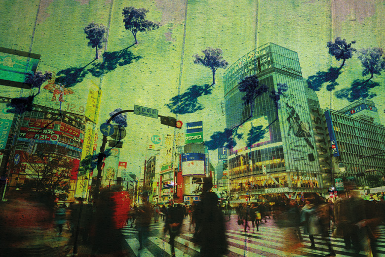
Source: Alamy montage


‘The great challenges of the 21st century are geographical in their formulation, analysis and consequence, and they transcend the physical/social divide’

To study the Earth, its biodiversity and humans as part of that, is to study geography.

A few decades ago, our discipline was in the academic doldrums. Split between the science of the physical world and the social science of humanity, it was accused of being a subject without a core: no more than a bunch of disparate interests and maverick academics gathered under the banner of place and space, teaching undergraduates of middling ability who were often set on a career in banking.

In the UK, the phrase “geography teacher” remains a term of abuse. It has been used to disparage the manners, attitudes and even sartorial elegance of individuals as disparate as Labour Party leader Jeremy Corbyn and musician Jarvis Cocker. Yet geography has never been more important than it is now. Humans have never been more networked, and we have never known so much about the natural world, its biodiversity, its chemistry, the flows of its energy that we capture and put to work and the consequences of our actions on a dynamic biosphere. The linking of all these things is the essence of geography, and the subject is enjoying a renaissance.

In 1971, US biologist Barry Commoner set out four laws of ecology in his book The Closing Circle: Nature, Man and Technology. These were: everything is connected to everything else; everything must go somewhere; nature knows best; and there is no such thing as a free lunch. Some might think this is all rather New Age and glib, but unpick these simple homilies and you reveal the origins of modern geography. It is indeed a scavenger discipline, picking up ideas from fields as diverse as ancient philosophy and modern biology and sticking them together. But connections lie at the heart of globalisation; nature is at the root of sustainability; and that lack of a free lunch is linked to the importance of equality.

This is because our well-being is based on mutual interdependence with each other and with the natural world. When the comparator countries’ overall levels of affluence are similar, people in more equitable countries tend to consume and pollute far less than they do in those where inequality is higher. If everyone on earth behaved, consumed and polluted like the citizens of the US, we would need four planets to live on. If we all lived as the far more equitable and ecological Japanese live, then we would need only two. Unfortunately that is still one planet more than we have.

Those three core concepts – globalisation, sustainability and equality – sit at the heart of 21st-century geography. This is arguably true regardless of whether it is focused on the physical processes of the natural environment or the less predictable complexity of human lives, states, wars and trade. These are the three areas of knowledge – conjoined with a humanistic philosophy – that acknowledge the pre-eminence of physical constraints on human endeavour. The future of geography includes developing a toolbox for transformative change. It is an action subject: geographers not only do fieldwork, they also become involved in activism, policy and advocacy.

The great challenges of the 21st century are geographical in their formulation, analysis and consequence, and they transcend the physical/social divide. These include climate change; accommodating 10 billion humans (which means coping with population ageing); maintaining biodiversity (slowing the rate of extinctions); enabling food production to rise (and eating less meat); managing increasingly diverse and growing urbanisation (and diaspora); and understanding the globalised flows of capital that undermine the concepts of the nation-state and democracy.

Geography has always been at the heart of trying to understand both the world humans inhabit and what it is to be human. Literally meaning Earth-writing, it is much older than the ancient Greeks who coined that term. It stretches from the earliest cave paintings depicting the animals that roamed the world and the very first field systems, to the design of new warped maps of our modern world: highly detailed gridded cartograms that portray the incidence and distribution of populations, their habits and their environments.

In Europe, we still remember Thales of Miletus, the philosopher and mathematician who, in the 6th century BC, used trigonometry to calculate distance and height and strove to explain the natural world without recourse to mythology. Today, we are learning (many of us for the first time) that a long geographical tradition was being developed in China at the same time. Gridded maps and complex inventories of places and resources – and the connections between them – were increasingly important knowledge for successive centralised Chinese states to exert power and control.

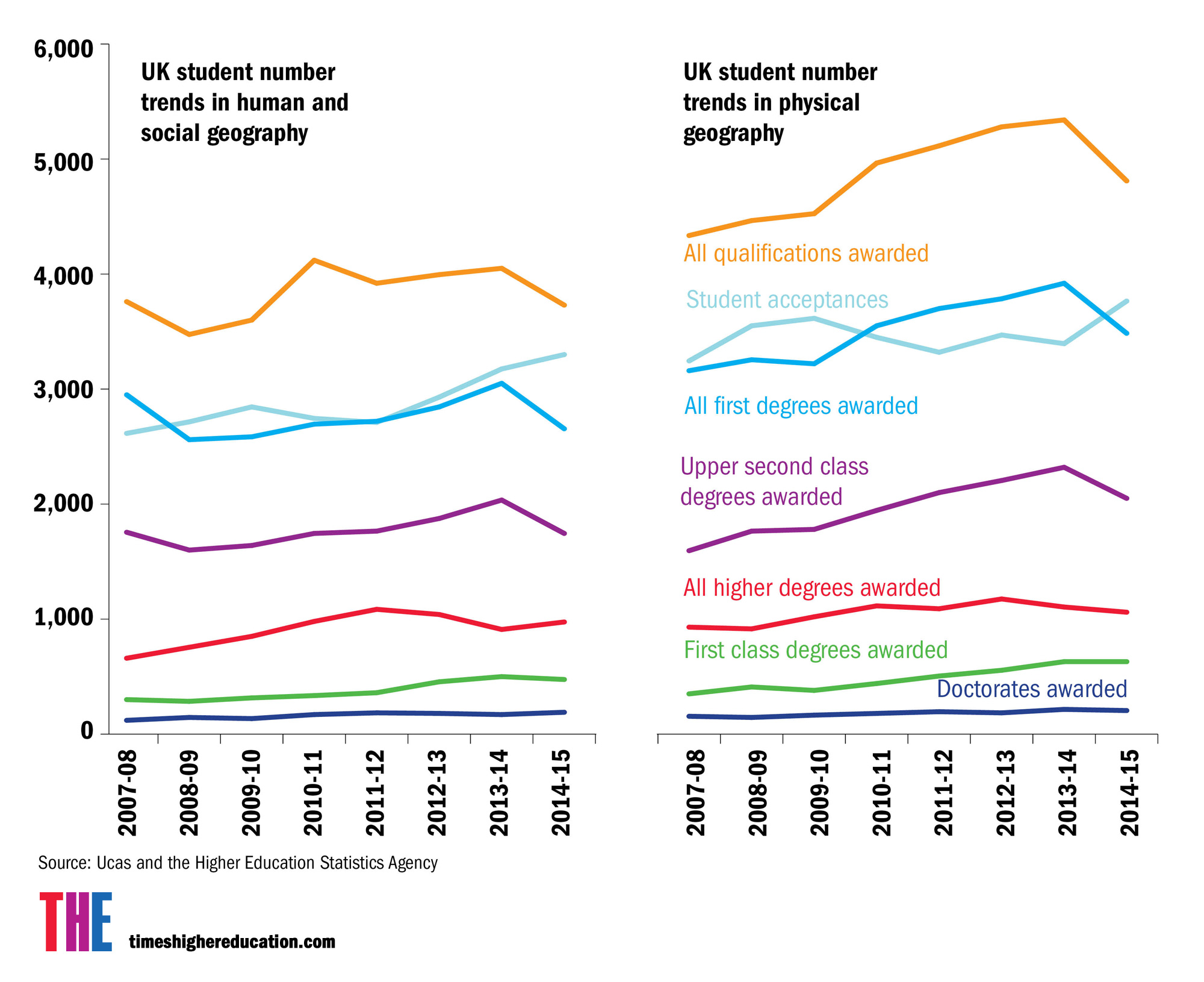
In the UK too, geography was traditionally the subject that every colonial officer needed to know. Modern-day geography remains strongest in places that still have imperial ambitions and/or legacies. In many other countries, the academic subject hardly exists, and few resources are found for its study. The US is still the nation with the most geographers, but the UK has the most per capita. More than 80 UK universities offer geography courses, according to the Royal Geographical Society. These are being taken by almost 30,000 students, of whom almost 3,000 go on to undertake postgraduate study in geography. Those numbers are rising, as are thenumber of schoolchildren taking GCSEs and A levels in geography.

The breadth of knowledge, perspectives and skills that go into a geographical education are increasingly applicable in a complex and continuously evolving labour market. The phrase “nexus thinking” is bandied about in the business world. What is meant by this is really geographical thinking, where phenomena, people, places and processes are all interwoven to create a fuller, more rounded understanding and, hopefully, an enhanced ability to make better choices about the future.

Geographers can’t claim pre-eminence for their subject. Memories of the mocking we received in the recent past helps to keep us in our place – and to understand geography is to understand that politics, economics, sociology, history, languages, chemistry, biology, physics and philosophy also matter very much. Nevertheless, no other subject so boldly ranges as widely across other disciplines: that is geography’s strength, not its weakness.

We can only marvel at the memories for arcane geographical facts displayed by the teams of students competing on the BBC television quiz programme University Challenge. But the real essence of geography isn’t “the facts”, but the ability to join them together to create something greater than the sum of the parts. Geography is about feeding the imagination that is required to join up all the disciplinary dots and to survey the planet that is our only home in the round: to reveal what our actions are doing to it – and to us as part of it.

No one can actually see the whole of the Earth’s surface at one time. You have to unwrap and unroll it to see it. As every geographer knows, that is the beginning of the process of making a map.

Carl Lee is a university tutor at the University of Sheffield and Danny Dorling is Halford Mackinder professor of geography at the University of Oxford. Their new book, Geography, was published by Profile this month.


Source: Ucas and the Higher Education Statistics Agency (Hesa)

‘Geography’s messy and unconventional profile is difficult for other academics to properly value, and this is increasingly threatening for the status and prosperity of the subject’

Almost 15 years ago, I wrote a commentary suggesting that geography was a discipline whose whole added up to less than the sum of its parts. I am not sure much has changed since then.

It is commonplace to argue that geography has an inbuilt and long-standing duality. Physical geography has a more scientific, positivist and quantitative leaning; human geography is, by nature, humanistic and qualitative. Hitherto, the subject has remained together despite recurrent tensions, but I wonder how long this can continue, and at what price.

Geography’s messy and unconventional profile is difficult for other academics to properly value, and this is increasingly threatening for the status and prosperity of the subject. For example, the recent managerial trend towards staff performance evaluation and metrics (citation indices, grant capture and publication patterns) is clearly more suited to the physical branch of the discipline. Successive research assessments reveal a subject that is quite evenly split between its two basic parts, but while physical geography faces “outwards”, publishing across the sciences; human geography is less diverse in its publication pattern, and arguably more cognate.

Such radically different subcultures cannot make for long-term harmony, especially when the resources needed to support physical geography are much greater but student numbers (the overwhelming source of university resourcing) can favour human geography. All this is exacerbated by the widespread phenomenon in the UK of appointing non-geographers, especially to physical geography posts. Colleagues are increasingly making such observations for themselves – it must only be a matter of time before management responds by questioning its commitment to unitary geography departments and considering less comprehensive degree and research offerings – as has already happened in some US institutions.

Furthermore, it is easy to foresee that a more empowered student body will demand greater, and more consistent, offerings in terms of curriculum, experience and value than geography is equipped to provide. Choice of degree pathway within the subject already leads to very divergent student experiences, not just between institutions but even within single departments – as seen in varying National Student Survey results. It is easy to foresee tension over, for instance, the role and provision of fieldwork. As universities compete for student income, they cannot afford to offer unattractive courses; the cost, exoticism and amount of fieldwork, which bears on student’s choice of university, will thus become a matter of institutional strategy. If fieldwork is integral to the discipline, the argument goes that it should be included in the basic fee. But that would make geography a relatively high-cost subject to deliver in an era in which the fee structure to support such subjects has yet to be worked out properly. A similar argument might also be made for laboratory work in physical geography: there are inevitably some hard choices to come.

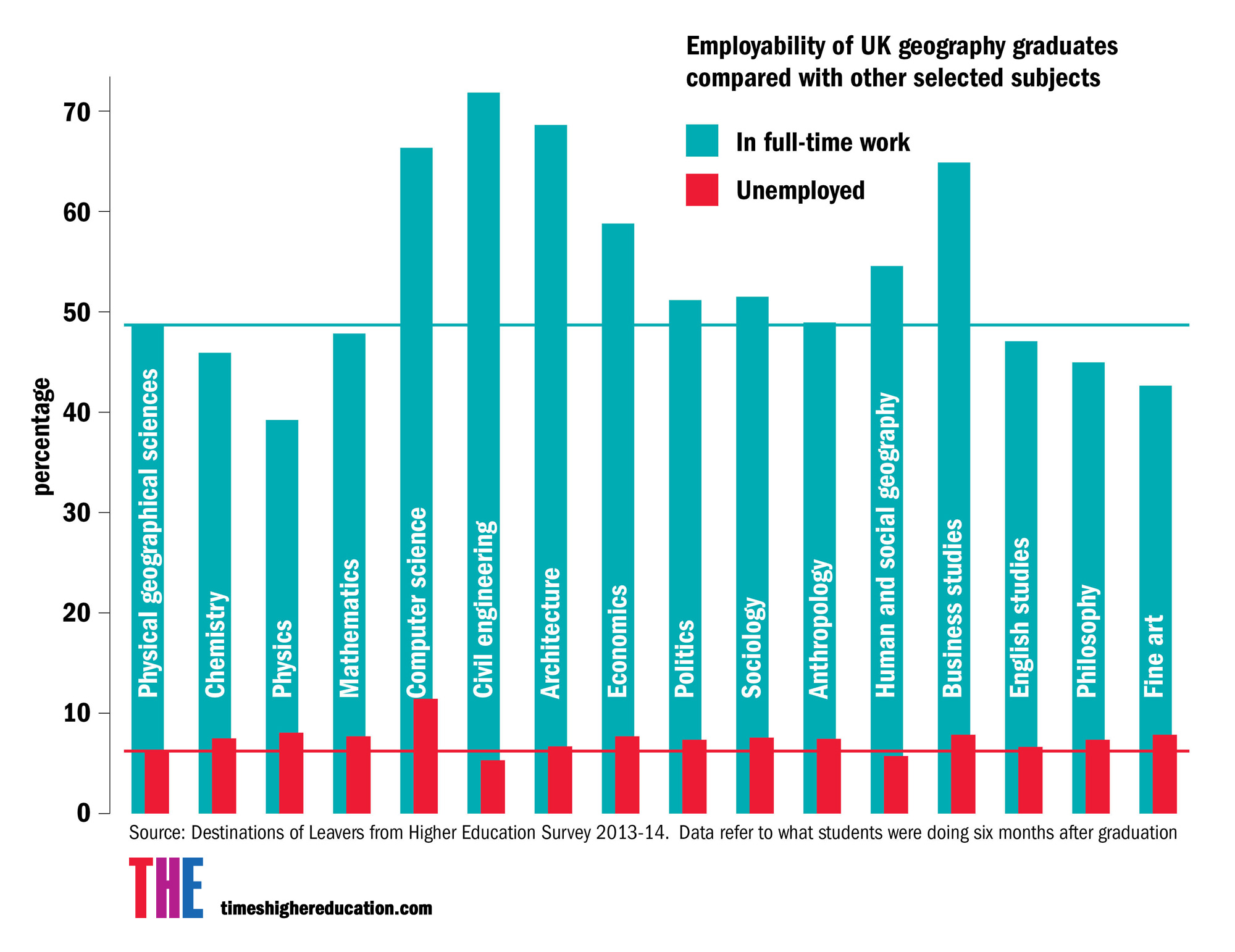
Geography has an excellent reputation for teaching quality and student employability, but it is one of many subjects in which an unfortunate void has opened up between school and university approaches, calling into question entry standards and expectations around progression. Academics were recently involved in reforming the A-level syllabus, but it is still unclear how the more systematised approach envisaged at school level can possibly map on to such diversity in the current university diet.

There is some scope for optimism, however. With the nature and scale of the human-environment issues we currently face – particularly climate change – geography’s unique juxtaposition of skills and perspectives could put it in the vanguard of a transdiciplinary approach, in which the framing of issues and answers is co-designed by scientists, academics and the public in new ways. This would also chime with universities’ renewed focus on their “third mission”: to create and share economic and social value by acting as brokers between public, academic, policy and business communities.

For instance, King’s College London has pioneered investment in the field of climate and culture, positioning an approach to climate change that moves beyond science and even social science, to address an emergent environmental humanities approach. Similarly, we have a new degree pathway focused around geocomputation (the acquisition, visualisation and analysis of big data, whether social, economic or environmental) that emphasises research skills and the presentation of knowledge as much as the learning of content.

The ultimate fate of geography over the next decade may thus rest on its having the confidence and the means to take ownership of some of the big issues of the day. For it to do this, some testing questions will need to be asked of it, whether from within its ranks or beyond. My suggestion, therefore, is that we geographers embrace our own tough love approach to our subject and undertake a sober survey of the territory that we are now traversing – and consider where we might go before we get irrevocably lost.

Nick Clifford is professor of physical geography and head of department at King’s College London. He is a chartered geographer and fellow of the Royal Geographical Society, and co-edits the flagship journal Geography, published by the Geographical Association.


Source:
Alamy montage

‘Geography is at its best when it uses new perspectives and asks new questions that shift how phenomena are fundamentally understood’

The essence of what unifies geography as an academic discipline is prone to being described in glib clichés in university prospectuses. Students are enticed with the opportunity to “study the world” or “make the world a better place”.

I have found myself using some of these phrases because it can be hard to capture what it is about geography that is so different from sociology, politics, anthropology, biology or management. But if I were to try a bit harder, I would say that geography is about how humans and landscapes vary across space, and the connection of these processes of transformation to each other and to their specific contexts.

This focus on change enables geographers to interpret and understand a dynamic and diverse world, and provides an opportunity to identify ways of making improvements – often underpinned by a progressive desire to make the world a fairer and more ecologically survivable place. It also places geography in the perfect position to intervene in the debates about uncertainty, insecurity and risk that dominate much contemporary political and public debate. The subject is at its best when it uses new perspectives and asks new questions that shift how phenomena are fundamentally understood.

Another of geography’s strengths is that, from a thematic perspective, it is not particularly coherent. Geographers are working in all corners of the world on a huge range of issues – from waste pickers in Delhi, to landscape processes in the southern hemisphere, eco-housing in the US, algae on Arctic glaciers and children’s experiences of education in Wales. This allows geography to be open and reactive to new issues, addressing them with a wide range of expertise that bridges the traditional divide between science and social science. Yet all too often, as researchers, we remain divided by language, methodologies and priorities.

One of the problems is that geography’s institutional centres are largely confined to developed countries, such that geographers too often interrogate issues from an uncritically adopted anglophone or Eurocentric viewpoint. This is slowly changing as post-colonial methodologies are more widely adopted and multilingual international teams are formed, but the mainstream and high-impact geography journals remain predominantly English-language, and the research questions asked by geographers can still be generated in isolation from research participants or the places in which we work.

In recent years there have been record numbers of applications to university geography courses. While their plurality is enjoyable for students, it can initially be disorientating. However, new additions to the A-level syllabus, such as cultural geography, will hopefully smooth the transition.

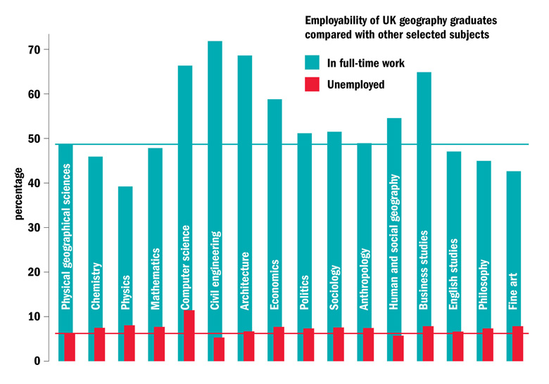
We aim to produce graduates who are adept in advanced analytical reasoning and critical thinking, and who possess a set of skills and techniques – from multivariate statistics to discourse analysis – applicable to the interrogation of a broad range of phenomena. In reality, many of us have long since specialised in particular methods, and our students tend to favour one and dislike others. But this broad education is a large part of the reason that they are in great demand from employers.

Ultimately it is this diversity of approaches, perspectives and methodologies that makes geography a vibrant and enlivening subject. It is boundless in what it investigates, shameless in what it borrows from other disciplines, and proud to do all it can to live up to that prospectus boast and make the world a better place.

Jenny Pickerill is professor of environmental geography at the University of Sheffield.


Source: Destinations of Leavers from Higher Education Survey 2013-14. Data refer to what students were doing six months after graduation

‘Neogeography has transformed the traditionally staid discipline of geography, whose teaching has sometimes amounted to little more than a cataloguing of capitals’

The discipline of geography has been transformed and invigorated in recent years by new technology. But continued resistance in some quarters to such data-led approaches could see the subject fail to live up to its potentially central relevance to modern life.

The idea of storing maps in computers dates from the 1960s, but it was the advent of the internet and smartphones that transformed map-making and analysis into a daily activity of the general public. The term neogeography was coined in 2006 to describe a new kind of geography in which distinctions between amateurs and professionals were no longer as clear, and in which maps of anything could be made by anyone, at in essence no cost, by providing information valid only for a few minutes, centred on the user’s location. All of these capabilities are familiar in the latest smartphone apps for driver, cyclist and pedestrian navigation.

Neogeography has transformed the traditionally staid discipline of geography, whose teaching has sometimes amounted to little more than a cataloguing of capitals and “capes and bays”. The analytical tools of so-called geographic information systems (GIS) became popular in the 1980s and 1990s, and have spread to virtually all areas of human activity dealing with the surface and near-surface of the Earth, including the social and environmental sciences and, more recently, the humanities. They are designed to allow virtually any conceivable operation on geographic data, from simple compilation and measurement to advanced analysis and modelling.

But the approach remains controversial, and perhaps more so in its applications to human than physical geography. It is impossible to measure location on the Earth perfectly because of numerous uncertainties in our knowledge of the planet’s shape and constant variation due to tectonic forces. Many mapping distinctions, such as that between urban and rural, are inherently vague. So the analyser of geographic data must always be aware of the potential differences between what is learned from the data and what is implied about the real world. The desire to “let the data speak for themselves”, which underlies the current drive to data-driven science, is clearly not the same as letting the geography speak for itself.

These issues can be addressed with a more thoughtful, critical approach based on sound theory. But GIS is still sometimes seen as a simple computer application, of no greater intellectual interest than word processing, that amounts to a way of avoiding engagement with the real world, and that constitutes a poor substitute for real geographic knowledge. GIS has also been attacked by geographers for its links to the military and intelligence communities, and because it has often been more accessible to the powerful than to the marginalised. Hence, the place of GIS within the discipline and its relationship with other disciplines remain a source of frequent tension.

It is true that several years after the advent of neogeography we still do not know whether society is more knowledgeable about the world around it or less. But this is all the more reason for academic geographers to engage with the technology, to maximise its usefulness in understanding and improving the world, and to benefit from its educational potential. If they don’t, students may continue to question the point of a geography degree.

Michael Goodchild is emeritus professor of geography at the University of California, Santa Barbara, and affiliate professor of geography at the University of Washington

Thursday, March 31, 2016

Two active Southern California faults may cause a Big One by rupturing togethe


Two of Southern California's most active faults could rupture together in a magnitude-7.5 earthquake, according to a new study, raising a grim seismic scenario for communities east of Los Angeles.

The study established how a major earthquake could begin on the San Jacinto fault and continue on the San Andreas, which is California's longest and one of its most dangerous faults.

The San Andreas historically has produced stronger earthquakes than the San Jacinto. But it's farther away from major development than the San Jacinto fault, which runs through San Bernardino, Colton, Moreno Valley, Redlands, Loma Linda, Hemet and San Jacinto, as well as near Riverside, Rialto and Fontana.


Full Coverage: Earthquakes in Southern California and beyond

"Because the San Jacinto fault cuts into the middle of the Inland Empire — instead of the edge of the desert — it cuts through a lot more people. There's just more people directly living on this fault," said Julian Lozos, a Cal State Northridgeprofessor of geophysics, who wrote the study while working on post-doctoral research at Stanford University and at the U.S. Geological Survey.


The faults also cut through freeways that connect Southern California to Nevada and Arizona, as well as lifelines that bring in electricity, fuel and water.

The earthquake envisioned in Lozos' scenario is not the biggest earthquake that could strike Southern California. The San Andreas alone could produce a magnitude-8earthquake.

But the study shows it's not just the San Andreas that should worry Southern California. There are, in fact, multiple pathways to get to a Big One, the kind of earthquake that could cause more than 1,000 deaths, ignite hundreds of fires, collapse buildings and leave lasting scars that take a generation from which to recover.

"There's a growing recognition that the fault network is more complex — and you can have the participation of multiple faults in a single rupture," said U.S. Geological Survey research geologist Katherine Scharer, an expert on the San Andreas fault who wasn't affiliated with the study.

"I think this study reflects the general agreement that the San Jacinto plays an almost-equal role to the San Andreas in terms of direct hazards to Southern California," Scharer said. "The San Jacinto goes right through downtown San Bernardino.

"For the larger Los Angeles region, a rupture on this fault could produce equivalent amounts of damage as the San Andreas," she said.


San Bernardino has no law requiring owners to retrofit brick buildings, which have collapsed catastrophically in previous earthquakes and are a known killer. (Irfan Khan / Los Angeles Times)

The reality could not be worse for San Bernardino — a city of 215,000 people that fell into bankruptcy in 2012 and suffers from one of the highest poverty rates among the nation's largest urban areas. San Bernardino has one of the largest concentrations of earthquake-vulnerable brick buildings in a location with a high risk of intense shaking.

San Bernardino has no law requiring owners to retrofit brick buildings, which have collapsed catastrophically in previous earthquakes and are a known killer. As of two years ago, there were more than 100 brick structures that haven't been retrofitted in the city.

Despite its lower profile, the San Jacinto fault has been a known risk for some time. It stretches for 130 miles, from the Cajon Pass in San Bernardino County southeast toward the Mexican border. The 1987 Superstition Hills earthquakes, which hit about 90 miles east of San Diego, topped out at magnitudes 6.5 and 6.7, and caused $3 million in damage in Imperial County.

The idea behind the study, funded by the National Science Foundation and published last week in the journal Science Advances, resulted from the scientific mystery of the great 1812 earthquake.

The quake was so extensive that the missions of San Gabriel, San Fernando Rey and San Buenaventura in Ventura reported damage. The quake sent the masonry of the Great Stone Church at Mission San Juan Capistrano tumbling, killing more than 40 people attending Mass; its ruins still remain to this day.

A classic explanation has been that it was the San Andreas fault alone that caused that earthquake.

But concrete evidence indicated only that the fault ruptured in 1812 on a 40-mile segment of the fault, between the Cajon Pass and Palmdale, Lozos said. The problem? That segment was too short to make an earthquake of that size.

Lozos began exploring a relatively new idea based on newly published paleoseismology reports generated by scientists investigating evidence of ancient earthquakes along the San Jacinto fault. These other scientists discovered evidence of a mystery earthquake in the early 1800s.

Lozos then posed a hypothesis: What if the 1812 earthquake was caused by the San Jacinto and San Andreas faults?

To test the idea, Lozos created a computer model. He gathered information on the shape of the faults, how seismic waves work with the local geology, and the suspected seismic stress on the faults.

The computer model showed that both the San Jacinto and San Andreas needed to rupture to produce the movement observed by the paleoseismologists, Lozos said.

Scharer said further study should occur to determine if the study's conclusions stand up to more scrutiny. But she said the approach was interesting: "It's using state-of-the-art computer models to ask if what has been observed in geology is possible, given the physics of the earth."

"It reminds people — just because they don't live on the San Andreas, that doesn't mean they aren't near an active earthquake fault," Scharer said.

There have been several examples of earthquakes jumping faults.

Earthquakes ruptured across multiple faults simultaneously in two earthquakes in the Mojave Desert: the 1992 magnitude-7.3 Landers earthquake and the 1999 magnitude-7.2 Hector Mine earthquake.

In Alaska, the magnitude-7.9 Denali earthquake ruptured across three different faults totaling more than 200 miles in length in 2002.

It happened again during the Easter Sunday earthquake of 2010, when a 7.2 earthquake and its aftershocks along the California-Mexico border triggered movement on at least six faults. One of the largest aftershocks, a magnitude 5.4, occurred about three months later from the main shock, and struck on the San Jacinto fault, Lozos said.


Other Big One scenarios rely on multiple faults rupturing at once. One is a theoretical magnitude 7.7 to 8.1 earthquake if faults rupture offshore of Santa Barbara and thencontinue east through Ventura, the San Fernando Valley, Altadena, Azusa and eventually to Rancho Cucamonga in San Bernardino County.

ron.lin@latimes.com

A version of this article appeared in print on March 17, 2016, in the News section of the Los Angeles Times with the headline "2 faults could add up to Big One - San Andreas and San Jacinto rupturing together may cause a magnitude-7.5 quake, a new study indicates." 

Wednesday, March 30, 2016

How rocks shaped the Civil War

SCIENMAG
March 17, 2016


Boulder, Colo., USA: The most studied battleground from the American Civil War, from a geological perspective, is the rolling terrain surrounding Gettysburg, Pennsylvania. Here, the mixture of harder igneous and softer sedimentary rocks produced famous landform features such as Cemetery Hill and Little Round Top that provided strong defensive positions for the Union Army.

Another even more common type of rock — carbonates such as limestone — provided similarly formidable defensive positions at numerous other battlefields in both the eastern and western theaters of conflict.

Limestones and dolostones shaped the terrain of multiple important battle sites, including Antietam, Stones River, Chickamauga, Franklin, Nashville, and Monocacy, and these rock types proved consequential with respect to the tactics employed by both Union and Confederate commanders.

This article by Scott P. Hippensteel of the University of North Carolina at Charlotte describes how carbonate rocks produced rolling terrain that limited the range and effectiveness of both artillery and small arms. Additionally, thin soils above limestone bedrock prevented tillage and the resulting forests provided concealment and cover for advancing troops. From a defensive perspective, on a larger geographic scale carbonates provided natural high ground from chert-enriched limestones. On a smaller scale, erosion of these same rocks produced karrens (or "cutters") that provided natural rock-lined trenches for defending troops.

FEATURED ARTICLE

Carbonate rocks and American Civil War infantry tactics

Scott P. Hippensteel, Department of Geography and Earth Sciences, University of North Carolina at Charlotte, 9201 University City Boulevard, Charlotte, North Carolina 28223, USA. Themed issue: Human Dimensions in Geoscience.

Tuesday, March 29, 2016

Parks Canada juggles competing claims to Franklin shipwrecks


Discovery of HMS Erebus wreck in Arctic waters produced dazzling objects — and ownership claims

Dean Beeby · Senior reporter, Parliamentary Bureau · CBC News March 8, 2016


Parks Canada has been in a tug of war with the government of Nunavut about who controls artifacts from the sunken Sir John Franklin ships in Arctic waters — and so far Nunavut is winning.

Nunavut officials refused to issue archeological dive permits to Parks Canada unless the federal government agreed to give up the authority to retrieve whatever artifacts it wants from the ocean floor.

Parks Canada initially balked at the restriction, but relented after getting advice that defying the Nunavut government could get their divers arrested by the RCMP.

Now, the agency must seek prior permission from Nunavut's director of heritage before retrieving anything from HMS Terror, the remaining lost ship from Franklin's ill-fated 19th century Arctic expedition to find the Northwest Passage.


A cannon from HMS Erebus, one of the ship's two six-pounder guns, is hoisted toward the surface during the 2015 artifact recovery mission in the Arctic. The government of Nunavut is requiring Parks Canada to seek prior authorization before divers can recover any artifacts from the still-lost companion ship, HMS Terror. (Thierry Boyer/Parks Canada)

The awkward outcome is yet another headache for Parks Canada, which is delicately navigating competing claims to the Franklin wrecks and artifacts.

Other claimants include the Kitikmeot Inuit, who have a say in the fate of the artifacts under a land claims treaty, and the British, who have the right to cherry-pick any artifacts that are of "outstanding significance" to the Royal Navy.

A CBC News investigation uncovered the jurisdictional tensions behind the dazzling headlines of the discovery of the wreck of HMS Erebus in September 2014 and the continued search for HMS Terror.

The spat with Nunavut began last spring, when Parks Canada applied for a permit to send divers to both the wreck of HMS Erebus and, if found, the wreck of HMS Terror.

"During the permit application process for the spring 2015 ice dive on HMS Erebus, the government of Nunavut included a condition that denied Parks Canada the authorization to recover artifacts from the wreck site," says a briefing note for Leona Aglukkaq, who was then the environment minister.

"Parks Canada responded to the government of Nunavut that it could not accept the condition," says the briefing, which noted the "risk of being charged" under the Nunavut Act. "The Royal Canadian Mounted Police have the authority to lay a charge." The note, and related documents, were obtained by CBC News under the Access to Information Act.
Trumps permit regulations

The federal cabinet subsequently declared the HMS Erebus wreck and surrounding waters a national historic site, which decisively trumped Nunavut's permit regulations.

But the other lost Franklin ship, HMS Terror, posed a problem because the wreck is almost certainly outside the boundaries of the national historic site and is therefore under Nunavut's jurisdiction.

Nunavut's insistence that Parks Canada get prior permission before retrieving any object from the wreck of HMS Terror put the agency in a difficult position.

"The ability to recover artifacts is a critical requirement of the search operation," says the briefing note.
'Ice conditions are ... raising the risk of permanent loss of artifacts'- Environment minister's briefing note

There's a "likelihood that evidence for HMS Terror will be spread over a debris field.… ice conditions are unpredictable, and there are no guarantees that additional searches will be possible in the coming years, raising the risk of permanent loss of artifacts."

In the end, Parks Canada acceded to Nunavut's demands, and agreed last June to seek prior permission of Nunavut's director of heritage before its divers remove any HMS Terror artifacts they may come across. Parks Canada is again applying for an HMS Terror dive permit this year, and Nunavut spokesman Doug Stenton says the same conditions will apply.


A boot was among the artifacts found during last summer's search of the wreck of HMS Erebus. (Parks Canada)

Just how that awkward arrangement will work is unclear. "The approval process would be managed on a case by case basis once Parks Canada archeologists identify potential artifacts for recovery," agency spokeswoman Kassandra Daze says in an email.

Complicating the artifact dispute is the Nunavut Land Claim Agreement, which requires the federal government to negotiate what's called an Inuit Impact Benefits Agreement for any area that it declares a national historic site, in this case the location of the wreck of HMS Erebus.

Talks on the benefits agreement have begun. A Kitikmeot Inuit spokesman says ownership and control of Franklin artifacts is a priority because the Inuit want the objects to be displayed in local communities to enhance tourism. So far, all 55 objects retrieved from HMS Erebus remain in Ottawa for conservation, including the ship's bell.
Britain has claim

"We'll all be coming to a table with our legal opinions at some point and trying to finally establish the ownership," says Fred Pedersen, director of planning and communications for the Kitikmeot Inuit Association in Cambridge Bay, Nunavut.

The British government also has a stake, based on a 1997 memorandum of understanding signed with Canada before any elusive Franklin wreck objects were found. The agreement acknowledges Britain's ownership of the wrecks and their contents, but says that country will assign ownership to Canada of everything recovered from the wrecks.

But there are two key exceptions. Any gold found will not be given up by Britain (none has been discovered yet). And "any recovered artifacts identified by Britain as being of outstanding significance to the Royal Navy will be offered to Britain for display in an appropriate museum."

A spokesman for the British High Commission in Ottawa, Nathan Skolski, says that "at present no items have been returned to the U.K. nor has the U.K. sought to do so." He adds that there currently is "no protocol for determining ownership."


A Parks Canada underwater archeologist positions reference lines in the debris field near the wreck of HMS Erebus. The search for Franklin's other ship, HMS Terror, will continue this year. (Parks Canada)

Daze confirms Britain has not assigned ownership of anything to Canada, 18 months after HMS Erebus was discovered.

She adds that Parks Canada's goal is to make the artifacts available for public display somewhere in Nunavut after a lengthy conservation process.

Since 2008, Parks Canada has spent about $1 million on its archeological dives for the Franklin wrecks.

Follow @DeanBeeby on Twitter

Friday, March 25, 2016

Virtual time machine of Earth's geology now in the cloud

Phys.org
March 9, 2016


A reconstruction of the supercontinent Pangea 180 million years ago. The colors correspond to fluctuations in the continental gravity field, which reflect the deep continental structure such as roots of ancient mountain chains, basins and …more

How did Madagascar once slot next to India? Where was Australia a billion years ago?


Cloud-based virtual globes developed by a team led by University of Sydney geologists mean anyone with a smartphone, laptop or computer can now visualise, with unprecedented speed and ease of use, how the Earth evolved geologically.

Reported today in PLOS ONE, the globes have been gradually made available since September 2014. Some show Earth as it is today while others allow reconstructions through 'geological time', harking back to the planet's origins.

Uniquely, the portal allows an interactive exploration of supercontinents. It shows the breakup and dispersal of Pangea over the last 200 million years. It also offers a visualisation of the supercontinent Rodinia, which existed 1.1 billion years ago. Rodinia gradually fragmented, with some continents colliding again more than 500 million years later to form Gondwanaland.

"Concepts like continental drift, first hypothesised by Alfred Wegener more than a century ago, are now easily accessible to students and researchers around the world," said University of Sydney Professor of Geophysics Dietmar Müller.

"The portal is being used in high schools to visualise features of the Earth and explain how it has evolved through time."

The virtual globes includes visual depictions of a high-resolution global digital elevation model, the global gravity and magnetic field as well as seabed geology, making the amazing tapestry of deep ocean basins readily accessible.

The portal also portrays the dynamic nature of Earth's surface topography through time. It visualises the effect of surface tectonic plates acting like giant wobble boards as they interact with slow convection processes in the hot, toffee-like mantle beneath Earth's crust.

"When continents move over hot, buoyant swells of the mantle they bob up occasionally causing mountains," said Professor Müller. "Conversely the Earth's surface gets drawn down when approaching sinking huge masses of old, cold tectonic slabs sinking in the mantle, creating lowlands and depressions in the earth's crust."

Since its inception the portal has been visited more than 300,000 times from more than 200 countries and territories. Individual globes have featured in numerous media articles around the world. The seafloor geology globe is the most popular, viewed on average 500 times per day. The globe allows the viewer to explore how different types of deep-sea sediments vary between ocean basins, and at different latitudes and depths.

"These cloud-based globes offer many future opportunities for providing on-the-fly big data analytics, transforming the way big data can be visualised and analysed by end users," said Professor Müller.

The interactive globes can be viewed on any browser at: portal.gplates.org


Read more at: http://phys.org/news/2016-03-virtual-machine-earth-geology-cloud.html#jCp