Visitors

Tuesday, January 31, 2017

Spectacular NEW photos of Earth finally arrive, see them all

Monday, January 23, 2017, 10:41 AM
The Weather Network

They're finally here! The very first images from the new GOES-16 weather satellite have been released, and not only are they beautiful to behold, but they reveal just how much of a leap forward this is going to mean for our daily weather forecasts.

It's been a little over two months now since NASA and NOAA launched the new GOES-R weather satellite into space, and now that it has settled into geostationary orbit and formally renamed GOES-16, we now get to see its "first light" images.

"This is such an exciting day for NOAA! One of our GOES-16 scientists compared this to seeing a newborn baby’s first pictures - it's that exciting for us," Dr. Stephen Volz, the director of NOAA’s Satellite and Information Service, said in a statement on Monday. "These images come from the most sophisticated technology ever flown in space to predict severe weather on Earth. The fantastically rich images provide us with our first glimpse of the impact GOES-16 will have on developing life-saving forecasts."

It's easy to understand their excitement, as - quite simply - these images are breathtaking.


GOES-16's Full Disk image from the Advanced Baseline Imager, at 1:07 p.m. EST, Jan 15, 2017. Click or tap the image to enlarge. Credit: NOAA/NASA

Compare this to the Full Disk image from the GOES-13 satellite, which was launched in 2006, and has been serving as the “GOES-East” satellite, returning imagery of the eastern half of North America, the Atlantic Ocean and all of South America, ever since.


GOES East Full Disk image from 12:45 p.m. EST, Jan 15, 2017. Credit: NOAA/NASA

According to NOAA, the full-disk image from GOES-16’s Advanced Baseline Imager (ABI) has four times the resolution of the GOES-13 image, and it was scanned 5 times faster.

Here is an example of what GOES-16’s predecessors currently give us, in 4-kilometre and 1-km resolution. Click or tap each image to enlarge.


4 km resolution GOES-13 image of the eastern United States, Ontario and Quebec, Jan 15, 2017. Credit: NOAA


1 km resolution GOES-13 image focusing in on the state of Colorado, Jan 15, 2017. Credit: NOAA


Here are corresponding examples from GOES-16’s “first light” images.


GOES-16 close-up view of the US northeast, Jan 15, 2017. Credit: NOAA/NASA


GOES-16 image of the US southwest and parts of Mexico, Jan 15, 2017. Credit: NOAA/NASA


As well, here is the new satellite’s full, continent-spanning view of North America.


Credit: NOAA/NASA

So, when GOES-16 finally becomes fully operational, later this year, we will not only get clearer, more detailed images of our weather, we’ll have access to that data far faster and far more frequently. This augmented capability will be invaluable for forecasters, especially when tracking potentially dangerous storms.

With these first light images now made public, it will be November before GOES-16 becomes fully operational, and it's still not clear, yet, which position it will take up at the time. It may become the new GOES-East or the new GOES-West satellite. The final decision will be made public in May.

Whichever part of the western hemisphere GOES-16 ends up covering, the other half won't have to wait long before it gets upgraded as well. According to NOAA, GOES-S is now being built and tested, and is expected to take up position to cover the rest sometime in the latter half of 2018.

Check out the rest of GOES-16's first-light images on NOAA's website, but here's one last amazing preview for now, showing the California coast, the limb of the Earth, and the Moon from geostationary orbit!


Credit: NOAA/NASA

Source

Monday, January 30, 2017

For London's Cabbies, Job Entails World's Hardest Geography Test

Roff Smith
National Geographic

Satellite navigation and GPS can't match the street smarts demanded by "The Knowledge" test.


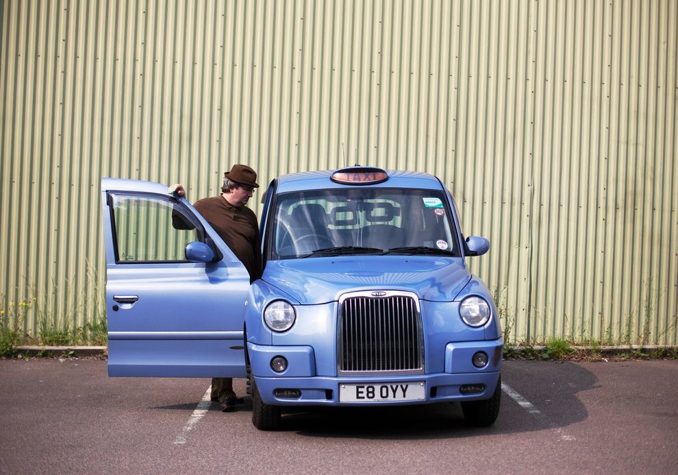
Veteran cabbie Ian Gordon alights from his cab at the KK Knowledge School to teach a lesson in London geography to a classroom full of aspiring cabdrivers. To gain a London cabbie's license, a candidate has to memorize all 25,000 streets and the locations of another 20,000 landmarks within a six-mile (9.6-kilometer) radius of Charing Cross.


LONDON—Steve Scotland had better reason than most for thinking he knew London like the back of his hand. Not only was he a native Londoner, born and bred, but he'd spent years working as a chauffeur in the city, driving his passengers wherever they wanted to go, finding the shortcuts, negotiating the city's traffic-clogged streets swiftly, accurately, and with a minimum of fuss.

So he quietly fancied his chances of passing "The Knowledge" test—the demanding test of London's back streets and landmarks that confronts anyone who wishes to join the elite ranks of London's cabdrivers.

"It was something I always wanted to do," Scotland says.


Robert Lordan sports the hard-won prize: the coveted green badge of a London cabbie.


In pursuit of this dream he went to the Public Carriage Office, which regulates taxis in London, and signed on for The Knowledge. After paying his fees and taking a map test and some written exams, he got hold of a motor scooter and set off to familiarize himself with his city in a whole new way.

Although "Knowledge Schools" exist to offer advice and help would-be cabbies prep for the series of examinations you have to pass along the way, the intensive learning of the city's streets and landmarks, the thousands of miles of exploration by scooter or on foot, is very much a do-it-yourself affair, all of it on your own time and at your own pace.

Nearly five years later, and with more than 10,000 miles (16,000 kilometers) clocked on the scooter, Scotland is still at it—although now, at least, it's with an end in sight. A good enough score on his next test, or "appearance," in a fortnight's time, and he'll have done it—cracked The Knowledge and earned himself the coveted green-and-white badge of a London cabbie.

"I had no idea how tough this would be," he says. "I really thought I knew the city well, but what I knew, or thought I knew, was nothing compared with what it takes to do The Knowledge." The five years he has spent on the quest is fairly typical. The Knowledge does not come easy.

ULTIMATE BRAINTEASER

Forget Mensa and armchair brainteasers. The Knowledge of London is a real-time, street-level test of memorization skills so intense that it physically alters the brains of those who pass it.

To qualify for that elusive green badge, you need to learn by heart all 320 sample runs that are listed in the Blue Book, the would-be cabbie's bible. You will also have to commit to memory the 25,000 streets, roads, avenues, courts, lanes, crescents, places, mews, yards, hills, and alleys that lie within a six-mile radius of Charing Cross.

Add to that the locations of another 20,000 landmarks and points of interest—pubs, clubs, museums, parks, monuments, railway stations, tube stations, hospitals, schools, police stations, government buildings, embassies, cemeteries, churches, guild halls, theaters, cinemas—any place, in other words, a fare-paying passenger might conceivably ask to be taken or an examiner might challenge you to find.


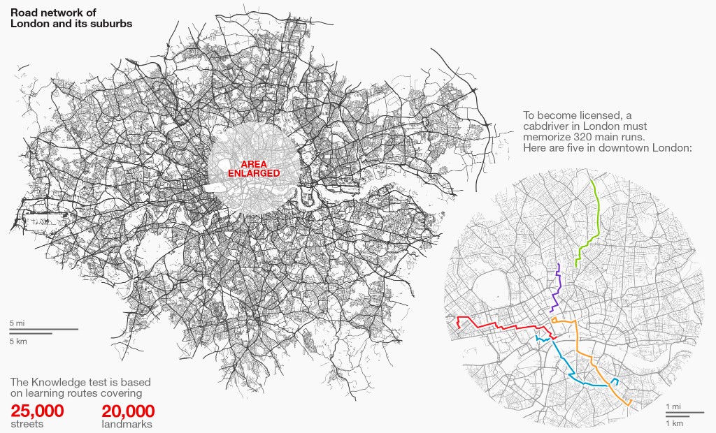
NGM Staff. Sources: London councils; London Black Cab; Open Street Maps


You'll need to know your way around so well that, when asked, you can calculate the most direct legal route between any two addresses anywhere in the entire 113-square-mile (293-square-kilometer) metropolitan area within seconds, without looking at a map, and be able to rattle off the precise sequence of streets, junctions, roundabouts, and left- and right-hand turns necessary to complete such a journey.

And you'll have to be able to do this consistently, not just once or twice, but in a potentially endless series of one-on-one oral exams, called "appearances," taken at regular intervals until the examiners are satisfied that you do indeed possess The Knowledge.

WHO NEEDS SAT NAV?

Even in this time of GPS and Google Maps, satellite navigation, or Sat Nav, is no match for a cabbie with The Knowledge. In May, London's Guardian newspaper pitted a cabbie against a Sat-Nav-equipped driver from Uber, the new "taxi" company that's taking the world's cities by storm by allowing passengers to book cars via their smartphones. The Uber driver did the run from the newspaper's office in King's Cross to Big Ben, in Westminster, in 22 minutes; the cabbie did it in 18, by taking a slightly longer route he knew to be quicker.

Such victories are points of pride these days within the ranks of London's cabbies, who have launched legal challenges against the upstart Uber. They claim that Uber drivers are acting as de facto taxis by using smartphones like taximeters to calculate fares. Only licensed taxi drivers—who possess The Knowledge—are allowed to work London's streets as taxis, metering their fares and being hailed from the curb.

A temporary ruling by London's transport authority last month found in favor of Uber on the grounds that the smartphone app that calculates Uber's fares was not connected to the vehicle in the manner of a traditional taximeter and was therefore not a taximeter within the meaning of the law. A British court will make a final determination on the matter next month.


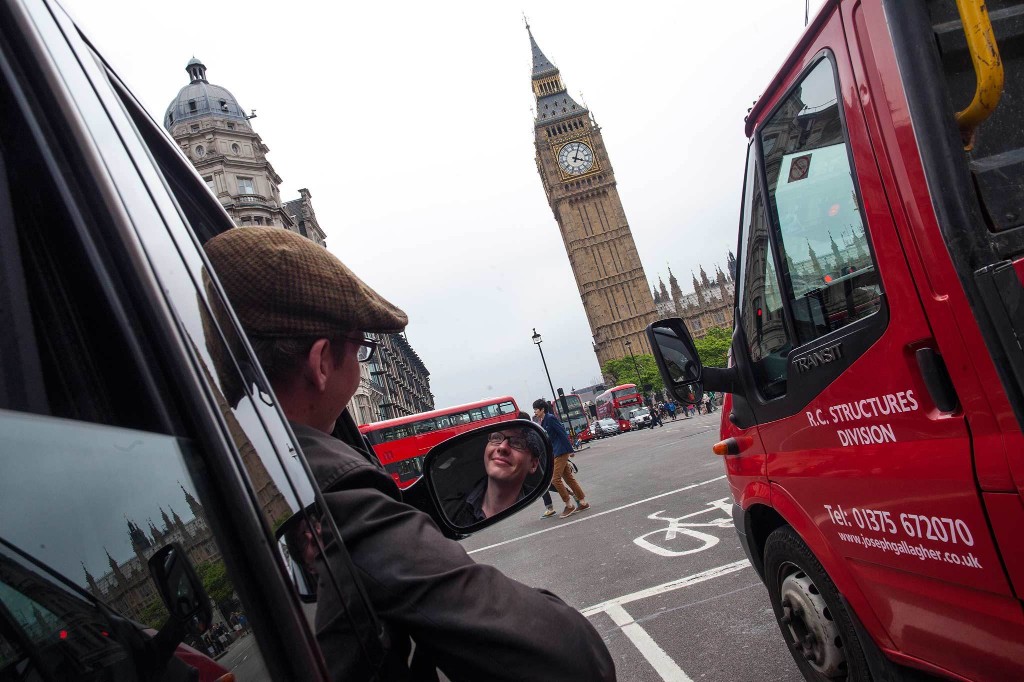
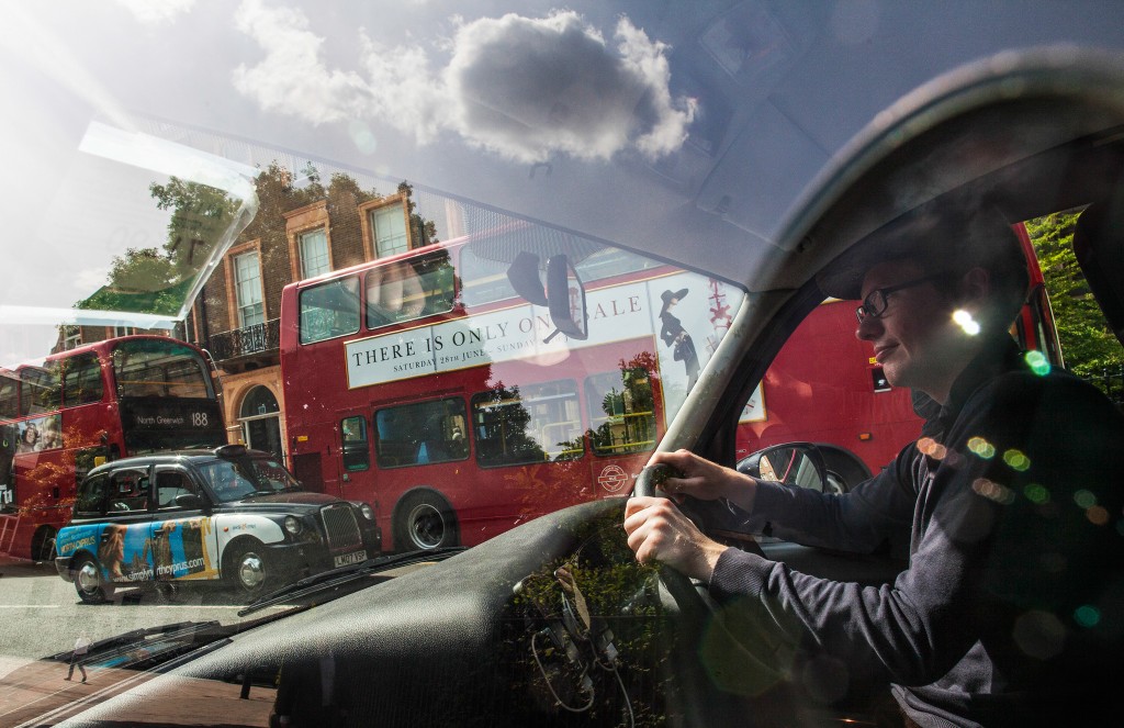
Robert Lordan navigates his new black cab in the vicinity of Big Ben and Parliament.


Proponents of Uber say Sat Nav technology makes The Knowledge obsolete. Not surprisingly, London's cabbies disagree. They're quick to point out that Sat Navs have a knack for getting things wrong, do not always pick the best or quickest route, and that having thousands of cabs idling curbside while their drivers punch in addresses for their Sat Navs will further clog London's streets, where average speeds have already dropped below nine miles an hour.

It's not simply a matter of speed, either, cabbies say. A driver who relies on Sat Nav doesn't know the city. "I like to put it this way," says 18-year veteran David Styles, who writes a blog about life behind the wheel: "When gentlemen have enjoyed supper at their club with their old regimental chums, they need a taxi to take them to the station. As they can generally afford to live in East Sussex, their station, Victoria, is only six minutes from Pall Mall. Depending on which entrance they want, they ask for The Shakespeare, Old Gatwick, or Hole in the Wall. Show me a Sat Nav which not only has that database but can be programmed in seconds, and I'll buy shares in it myself."

He continues: "And actors don't want to arrive at the front of the theater. They want the stage door. And yes, we have to learn those too."

Hail one of London's iconic "black" cabs (which nowadays can come in any color) from anywhere you please within the greater London area, tell the driver where you want to go—it doesn't matter whether it's the Tower of London or some obscure pub in an outer suburb—and by the time you've climbed in the back seat and closed the door, he'll have already calculated the most direct, swiftest route, without ever looking at a map.

What if you're not quite sure where you want to go? Say you're visiting London, you've reserved tickets to see The 39 Steps, and you're picking them up at the box office, but you can't recall the name of the theater. Just name the play, and your cabbie will take you—in this case, straight to the Criterion on Piccadilly Circus.

THE "NERVOUS WRECK"

London cabbies don't just happen to know these things: For more than 150 years they've been required to be the consummate experts on their city. The whip-cracking drivers of those Victorian hansom cabs Sherlock Holmes was forever hailing all had to bone up for the world's toughest geography test, just as the roughly 25,000 drivers of London's cabs must today.


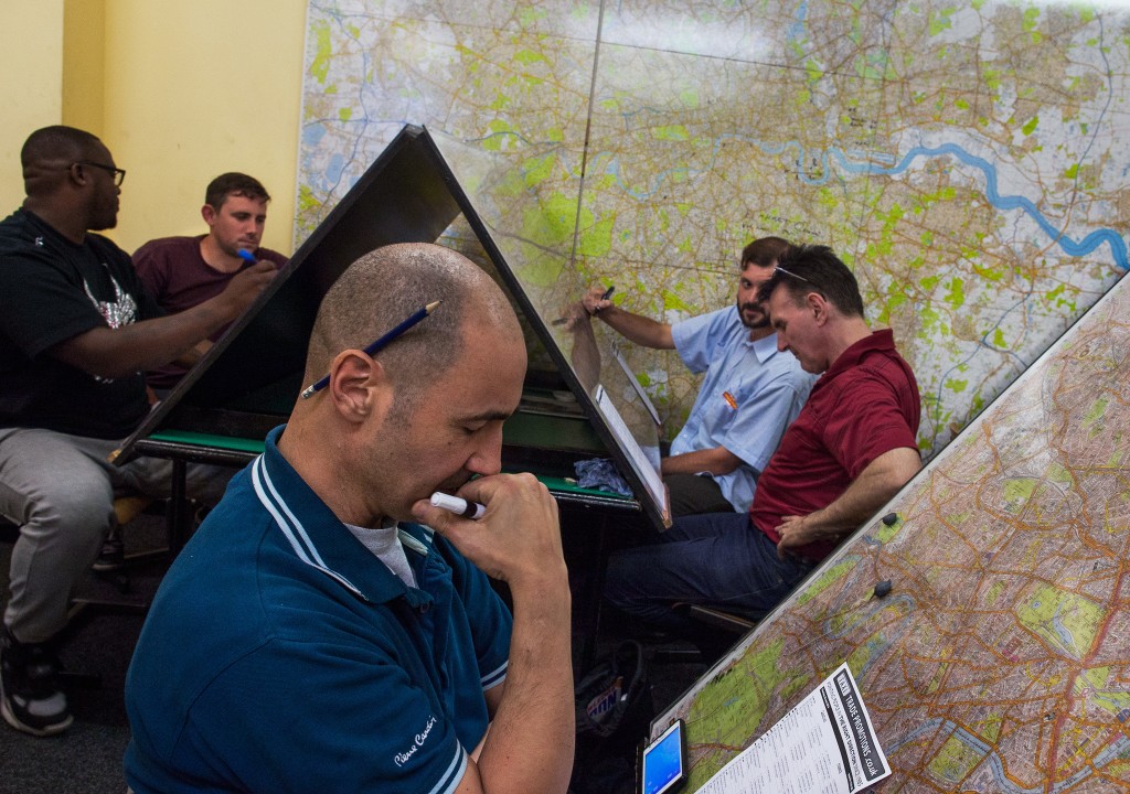
Students study maps at London's Knowledge Point School, one of many that have sprung up to help the 6,000 or so people who are candidates at any one time.


The final series of tests, known as the "required standard," or "req" for short, is known among cabbies as the Nervous Wreck. Here's where the last-minutes jitters creep in.

Indeed, Steve Scotland would have had his badge a few weeks ago, at his last appearance, had he not miscued a turn and dropped his hypothetical passenger off on the wrong side of the street. "Just nerves," he recalls. "All I had to do was pick up at the cab rank at Sainsbury's [supermarket] on Liverpool Street and drop off at the emergency entrance at the Moorfields Eye Hospital. That's a run I can do in my sleep."

But he bobbled when it counted. As a result, instead of spending this Sunday afternoon sitting home watching the World Cup, as he'd been looking forward to, he's once more astride his scooter, still a "Knowledge Boy," puttering along Great Swan Alley, just off Copthall Avenue, in London's financial district, brushing up ahead of his next—and hopefully final—appearance.

"A new restaurant has opened up around here, and I want to get it fixed in my mind—just in case," he says. "You just never know what the examiners are going to ask you."

KNOWLEDGE BOYS (AND GIRLS)

Cabbie apprentices such as Scotland are Knowledge Boys. There are Knowledge Girls too, but fewer than 2 percent of cabbies are women.

Cabbies come from all walks of life—students, tradesmen, lawyers, teachers. David Styles was a typesetter for one of London's oldest printing companies. Most grew up in or around London, but people from elsewhere in Britain, and even a few foreigners, have successfully completed The Knowledge.

"I was studying biology," says 24-year-old Osman Jamal Zai, who left school six months ago and began studying The Knowledge. "This just seemed like a better idea, and I have to say I'm loving it."


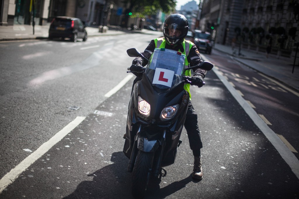
"Knowledge Boy" Stuart Moore makes a "pointing run" on his scooter—tracking down the locations of some of the thousands of points of interest he'll need to know by heart if he's to earn his green badge. Scooters are the preferred Knowledge vehicles because they're cheap to run and highly maneuverable.

By all accounts, being a London cabbie pays well. Although the cabbies themselves are cagey about what they earn, it's widely accepted that incomes of $100,000 (U.S.) a year aren't unusual, with some operators—those working extremely long hours—believed to be making that figure in pounds sterling (roughly $170,000 U.S.).

Aside from the money, the draw for many is the ability to set their own hours and achieve an enviable work-life balance. And unlike many cities—Paris, for instance, which imposes strict limits on the numbers of cabs—London is wide open. Anyone of good character can get a cabdriver's license, as long as he or she passes The Knowledge.

The nearly five years Scotland has spent on that quest isn't unusual. "It took me four years, 11 months, and 13 days," Styles says.

While a fortunate few—those who can afford to pursue the training full-time—can complete it in as little as two years, most have to fit The Knowledge in around work and family commitments.

"I'm guessing it'll take me around five years," says 53-year-old David Greenhalgh, an IT specialist who's spent the past two years juggling street explorations and his day job.

IN PURSUIT OF WORSHIPFULS

This weekend, Greenhalgh is taking advantage of the relative lack of bustle to learn the tangled arteries in the neighborhoods between Cannon Street Station, London Wall, and St. Paul's Cathedral. He's on foot, with a rucksack slung over his shoulder, and a guide to London's 110 livery companies—just some of the thousands of points of interest whose locations he will need to know by heart.

In the past couple of hours, he's tracked down the Worshipful Company of Mercers, the oldest of London's liveries, founded in 1394, as well as the grandiose building housing the Worshipful Company of Vintners (on Upper Thames Street) and the Worshipful Company of Stationers and Newspaper Makers, in a secluded square off Ave Maria Lane.


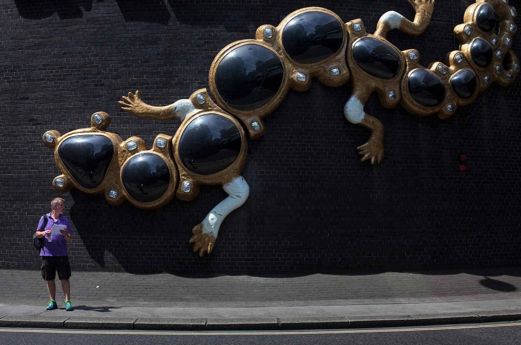
A massive salamander—replica of early jewelry from the Cheapside Hoard—on the rotunda outside the Museum of London makes a fanciful backdrop for Knowledge boy David Greenhalgh as he does a pointing run for livery halls.


On such a fine, warm summery Sunday afternoon as this, a quixotic nosing about for London's old livery halls seems like the pleasantest kind of tourism—sightseeing with a purpose.

"It's not always like this," Greenhalgh laughs, as he pauses to photograph the ornate portal to the Worshipful Company of Apothecaries, whose 17th-century headquarters is hidden away down a picturesque cobbled lane not far from Blackfriars Station. "You have to get to know the dodgy neighborhoods too."

THE WINNOWING

Only about one in five of those who attempt The Knowledge ever make the grade. "You can never actually fail," Styles says. "There's only quitting. You're allowed to keep trying as long as you like." The overwhelming majority drop out in frustration after a year or so.


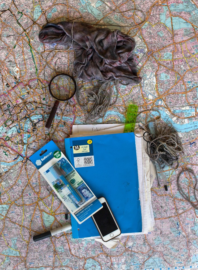
Tools of the trade: Maps, pens, magnifying glass, pins, and cotton thread for linking points and finding the shortest routes are some of the study aids for those doing The Knowledge.

To put the success rate into perspective, the percentage of people who successfully complete The Knowledge is roughly the same as that of candidates who make it through the training to become a U.S. Navy SEAL.

"There are no shortcuts," says 79-year-old cabbie Alf Townsend, who did The Knowledge in 1962 and still drives his cab a few hours a day to mingle with old friends and keep his hand in.

"You can't do it by sitting at home, memorizing maps and street names, and hope to pass that way. You have to get out on the streets, putting in the miles, seeing and experiencing everything firsthand. There's no other way."

ROYAL ROOTS

It was King Charles I who, in 1636, launched London's taxi service—the world's oldest—by granting royal permission for 50 hackney carriages to "ply their trade."

A few years later, in 1654, Oliver Cromwell put in place the framework of regulations under which the hackneys operated, but it was a stern Victorian police commissioner, Sir Richard Mayne, who dreamed up The Knowledge in the early 1850s.

Dismayed by the number of complaints from visitors at the Great Exhibition of 1851 that London cabbies didn't seem to know where they were going, Mayne made it a requirement that anyone seeking a cabbie's license be an expert on the city. And so The Knowledge was born.

Although the city has changed past all recognition since the 19th century, when a series of sample cab runs were formulated by the Public Carriage Office to create a framework for studying and testing, the demands of The Knowledge have hardly changed.

A candidate who mastered all the runs and knew them by heart, and who knew all the streets and landmarks in a quarter-mile radius around each start and end point, could be considered to have acquired The Knowledge.

The precise number of runs has varied over the years, but today there are 320, and they're found in the Blue Book (which is pink).

BEING "ON THE COTTON"

"In some ways, people doing The Knowledge today have it easier than we did 50 years ago," Townsend says. "We had to figure out the shortest routes for ourselves, sticking pins in maps at the end points, tying threads between them, then trying to work out the route that stayed closest to the thread. Being 'on the cotton,' it was called. Nowadays you can buy books and apps that have the correct routes already worked out for you."

There are also Knowledge Schools, taught by veteran cabbies, to help candidates learn the runs and prepare for the exams. The examiners are said to be more reasonable now—still austere, but a bit less like Royal Marine drill sergeants and a bit more like Mr. Chips.

There's better gear too, according to Townsend—no small consideration for anyone who has to ride thousands of miles around the streets of soggy old London town on a scooter.

"I nearly froze," he recalls. "All I had was a garbage bin liner over me to keep out the rain, a waterproof fisherman's hat, and a couple of my wife's scarves wrapped around my neck to try to keep me warm. Nowadays they have Gore-Tex and heated gloves."

Some things never change. Manor House Station to Gibson Square is still the very first of the 320 Blue Book runs a would-be cabbie is expected to know.

Lordan Manor House Run

"I started out very early one Sunday morning," says Robert Lordan, a 33-year-old former schoolteacher who, like Styles, writes a blog on cabbie life. "I remember it was eerily quiet. I felt as though I had the entire city to myself. I was full of excitement, very much looking forward to exploring and learning London."

The traditional first run, he discovered, was gratifyingly easy to learn—a reasonably straightforward journey, 2.9 miles (4.7 kilometers) long, between a nondescript Tube station on the Piccadilly Line and a quiet square in fashionable Islington.

"I'd prepared considerably beforehand, poring over the map, and being a beginner, I drove it several times to make sure I was familiar with every turn and junction." Then he moved on to the next run, and the next. "On average, I would spend three to four hours on each," he says.

To master a route for testing purposes, a student has to not only memorize the streets linking the two end points but also be intimately familiar with the back streets and landmarks within a quarter-mile radius around those points.

"An examiner quizzing you on a run is never going to ask you anything straightforward like, 'Take me from Manor House Station to Gibson Square,'" Lordan says. "He'll always pick some address that's just around the corner or a couple streets away."

Initial enthusiasm soon wanes in the face of the mind-boggling complexity of London's labyrinthine streets and the sheer frustration in trying to learn them all.

"There comes a time, about a year into it, when you really begin to doubt what you're doing," Lordan says. "For me, it was the intricate one-way systems and myriad dead ends in parts of North London, especially around Islington. They had me pulling my hair out. I didn't think I was ever going to get those straight."

Eventually though, with persistence, he says, there comes a tipping point, when it all starts to make sense. "It's like putting together a jigsaw puzzle. Suddenly you see it. You spend so much time on the streets and studying the map at home that it etches itself on your brain. An analogy I like to use is that it reminded me of starting secondary school as a child. At first, the building seemed huge with its many rooms, wings, and corridors. But after a while, you get to know the place and navigating it becomes second nature."

RESHAPING THE BRAIN'S GEOGRAPHY

Starting school is a good analogy for learning The Knowledge. A study by neurologists at University College London found that the hippocampus, the part of the brain responsible for spatial navigation, of a London cabby is significantly larger than those in the rest of the human population—a result of the intense memorization and route-finding undertaken while doing The Knowledge.

The study involved taking regular brain scans of Knowledge-seekers undergoing their training and comparing them with scans taken of a control group of people who had no interest in becoming cabdrivers.

At first, the hippocampi of all the study subjects were of similar size, and all subjects performed similarly on routine memory and route-finding tests. By the end of the study, though, those who'd passed The Knowledge had larger hippocampi, and the longer they worked as cabbies, the larger their hippocampi became.

"We don't know what is changing in the hippocampi of taxi drivers," says Eleanor Maguire, who led the study. "Whether it's new neurons that are being produced, new connections between neurons, proliferation of other cell types, or all three.

"There's been a lot of research looking at trying to associate different brain areas with certain skills—musicians or linguists, for example," she says. "The key point about London taxi drivers is that they acquire their navigational expertise when they're adults, unlike musicians, who often start when children, and so there's the added factor of the interaction between brain development and skill acquisition."

"CALLING OVER"

Certainly, the hippocampi of London cabdrivers get a lot of intensive exercise. Every day David Greenhalgh recites at least 30 of the 320 runs he has memorized—every turn, junction, and roundabout.

"I work my way up through the list and then start all over again," he says. Reciting these runs is known as "calling over." Knowledge students often get together to recite them to each other. The call over for Manor House Station to Gibson Square would be:


Leave on left—Green Lanes

Right on Brownswood Road

Left on Blackstock Road

Forward on Highbury Park

Forward on Highbury Grove

Right on St. Paul's Road

Comply Highbury Corner

Leave Upper Street

Right on Barnsbury Street

Left on Milner Square

Forward on Milner Place

Forward to Gibson Square


After the 320 runs are memorized, The Knowledge student begins the long battery of oral tests. The first are called 56-day appearances, given every eight weeks.

"The examiner asks you to do four runs," says Greenhalgh, who's made it through two 56-day appearances thus far. "Each run is worth ten points. If you get a perfect score of 40—something phenomenally rare–you get an A and advance straight to the next level, your 28-day appearances."


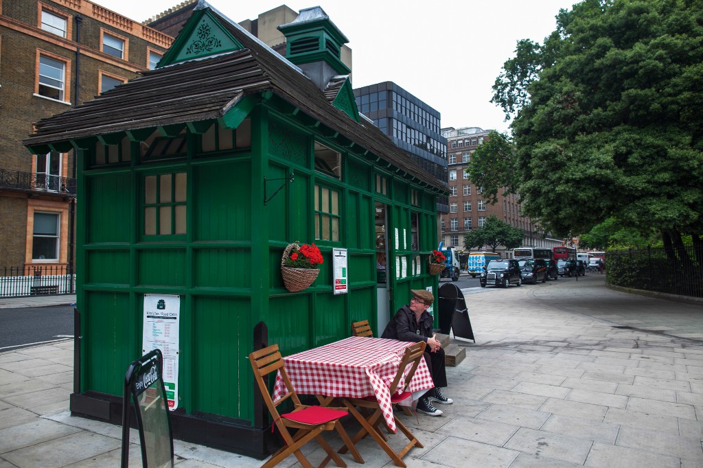
London cabbie Robert Lordan takes a break at the venerable Victorian cab shelter on Russell Square, one of 13 scattered around the city where cabdrivers can stop for a break, a bacon sandwich, or a cup of tea and a chat with colleagues. The shelters were originally set up in 1875, in the horse-drawn days, to provide cabbies with shelter from London's damp and chill.

Lesser scores are awarded B or C or D grades, and the student returns in 56 days to try again. Grading is strict. Points are deducted for "hesitancy," and making an illegal turn or going the wrong way on a one-way street earns you a big fat zero. To advance to the next level of testing, a candidate needs the equivalent of two B's or four C's.

A grade of D gets you nowhere.

If after seven attempts you've not scored well enough to move on to your 28-day appearances, the slate is wiped clean, and you start the 56-day tests all over again. This setback happens to as many as 80 percent of first-time Knowledge students.

When you get to your 28s, the exams come every four weeks and proceed along exactly the same lines as the 56-day ones, only now the questions are even more demanding.

As before, a rare perfect score of 40 advances you to the next tier, but most muddle through—if they get through at all—with combinations of B's and C's.

As before, a D earns you nothing, and if you fail to advance after your seven appearances—"red-lining," in the vernacular—you go back and start your 28s again. Fail twice, and you go back to your 56-day appearances.

Eventually, if you persist, you reach your 21-day appearances—the final tier. Scoring here is just the same, with the same number of tests, only now the questions and expectations are tougher still.

GROWN MEN CRYING

"It's a very emotional moment when you realize you've done it and get that handshake from the examiner," says Lordan, who passed four-and-a-half years ago.

"I know I got quite teary. They tell me a lot of guys cry when they get their badge—you've invested so much of yourself, your time and your life, into doing this, to reach the end is just incredible."

Lordan's victory came on December 22. Two nights later, on Christmas Eve, he went out as a London cabbie for the very first time, driving a cab he'd leased. His first fare was a group of South African tourists who congratulated him on his achievement. Following the long-standing first fare tradition, he told them there was no charge. "They insisted on paying me anyway," he says, "and so I donated the money to charity."

Lordan and I are standing beside an old, green Victorian cabman's shelter on Russell Street—one of 13 still in existence around the city where cabbies can get mugs of tea and bacon sandwiches and take a rest. Parked a few feet away is the gleaming, built-in-Coventry black cab he bought eight months earlier, and on which he's already clocked 14,000 miles (22,531 kilometers).

With the ease and fluency of a man who has The Knowledge, and the passion of a true historian, Lordan explains how the shelters were founded by Captain George Armstrong in 1875 to give London's taxi drivers somewhere to keep warm and dry.


Lordan behind the wheel of his new black cab. "The best thing about being a London cabbie is the people you meet," he says. "I meet people from across the globe—ambassadors, celebrities, WWII veterans, politicians, parents taking their newborn baby home, people who've survived genocide in their homeland. Ninety-nine percent of the people I meet in my taxi are wonderful. To meet such a wide array of people every day is truly life affirming."

Armstrong had "sent his manservant out to hail a cab in a blizzard," Lordan says. "He came back an hour later and said they were all in pubs, and none of them were in any fit state to drive. And so he established these shelters."

Lordan is one of a small percentage of cabbies who have gone on to complete the Worshipful Company of Hackney Carriage Drivers' course to become a licensed tour guide—a sort of post-doc among those who have The Knowledge. He offers tours on London's famous murders, Harry Potter landmarks, and American sites of interest. "Did you know Benjamin Franklin had a house here?" he asks.

"Doing The Knowledge has made me somewhat obsessive," he laughs. "I'm constantly striving to improve my grasp of the city, to learn as much as I can. I love this job. I'm always learning something new. As Samuel Johnson said, a man who's tired of London is tired of life."

Elizabeth Dalziel

Saturday, January 28, 2017

Here are the 4 geopolitical hotspots of 2017

George Friedman and Jacob L. Shapiro, Mauldin Economics/Jan 22, 2017

In geopolitics, a deep understanding of geography and power allows you to do two things. First, it helps you comprehend the forces that will shape international politics and how they will do so. Second, it helps you distinguish what is important from what isn’t.


This makes maps a vital part of our work, here at This Week in Geopolitics. So we have decided to showcase some of the best maps our graphics team (TJ Lensing and Jay Dowd) made in 2016.


These four maps help explain the foundations of what will be the most important geopolitical developments of 2017.


Mauldin Economics

MAP 1: RUSSIA’S ECONOMIC WEAKNESS

This map shows three key aspects to understanding Russia in 2017. (For my full 2017 geopolitical forecast for Russia, click here.) First is the oft-overlooked fact that Russia is a federation. Russia has a strong national culture, but it is also an incredibly diverse political entity that requires a strong central government. Unlike most maps of Russia, this one divides the country by its 85 constitutive regions. (87 if you count Crimea and Sevastopol.) Not all have the same status—some are regions, while others are autonomous regions, cities, and republics. The map also highlights the great extent of economic diversity in this vast Russian Federation. The map shows this by identifying regional budget surpluses and deficits throughout the country. Two regions have such large surpluses that they break the scale: the City of Moscow and Sakhalin. Fifty-two regions (or 60% of Russia’s regional budgets) are in the red. The Central District, which includes Moscow, makes up more than 20% of Russia’s GDP, while Sakhalin and a few other regions that are blessed with surpluses produce Russia’s oil. The third point follows from the first two. Russia is vast, and much of the country is in a difficult economic situation. Even if oil stays around $55 a barrel for all of 2017, that won’t be high enough to solve the problems of the many struggling parts of the country. Russian President Vladimir Putin rules as an authoritarian. This is, in part, because he governs an unwieldy country. He needs all the power he can get to redistribute wealth so that the countryside isn’t driven to revolt. Russia is making headlines right now because of Ukraine, Syria, and alleged hacking. But the geopolitical position of Russia is better described by studying the map above.


Mauldin Economics

MAP 2: CHINA’S CAGE LIMITS ACCESS TO THE PACIFIC

Maps that shift perspective can be disorienting, but they are meant to be. Our minds get so used to seeing the world in one way that a different view can feel alien. But that is even more reason to push through the discomfort. The map above shows us the Pacific from Beijing’s perspective. China's moves in the South China Sea have received a great deal of attention. In a Jan. 12 confirmation hearing with Congress, nominee for US Secretary of Defense James Mattish pointed to Chinese aggressiveness as one of the major reasons he thinks the world order is under its biggest assault since World War II. But we believe the Chinese threat is overstated. This map helps explain why. China’s access to the Pacific is limited by two obstacles. ( I wrote about this extensively in This Week in Geopoliticssubscribe here for free ). The first is the small island chains in the South and East China Seas. When we look at this map, China’s motive in asserting control over these large rocks becomes clear. If China cannot control these islands and shoals, they can be used against China in a military conflict. The second obstacle is that China is surrounded by American allies. Some such as Japan (and to a lesser extent South Korea and Taiwan) have significant military forces to defend themselves from Chinese encroachment. Taiwan sticks out as a major spur aimed squarely at China’s southeast coast. Those that don’t have sufficient military defenses, like the Philippines, have firm US security guarantees. China is currently at a serious geographic disadvantage in the waters off its coast. This map does not reveal one important fact. That is the US Navy outclasses the Chinese navy in almost every regard… despite impressive and continuing Chinese efforts to increase capabilities. But looking at this map, you can see why China wants to make noise in its coastal waters and how China is limited by an arc of American allies. You can also see why one of China’s major goals will be to attempt to entice any American allies to switch sides. China’s moves regarding the Philippines will require close observation in 2017.


Mauldin Economics

MAP 3: GEOGRAPHICAL POWER IN THE MIDDLE EAST

It has become cliché to point out that the Middle East’s current political borders were drawn after World War I by colonial powers (like the UK and France), and that the region’s recent wars and insurrections are making these artificial boundaries obsolete. What isn’t cliché is doubling down on that analysis. We’ve drawn a new map… one that reveals what the Middle East really looks like right now. Some will object to some of the boundaries for political purposes, but this map is not trying to make a political statement. Rather, it is an attempt to show who holds power over what geography in the Middle East. From this point of view, Syria, Iraq, Yemen, and Libya no longer exist. In their places are smaller warring statelets based on ethnic, national, and sectarian identities. Other borders (like those of Lebanon and Israel) are also redrawn to reflect actual power dynamics. Here, a politically incorrect but accurate map is more useful than an inaccurate but politically correct one. It is also important to note which countries' borders do not require redrawing . These include three of the region’s four major powers: Iran, Turkey, and Saudi Arabia. The borders of the other major power, Israel, are only slightly modified. (Egypt is an economic basket case. It doesn’t qualify as a major power, even though it has one of the most cohesive national cultures in the Arab world.) The Middle East is defined by two key dynamics: the wars raging in the heart of the Arab world and the balance of power between the countries that surround this conflict.


Mauldin Economics

MAP 4: NATIONALISM AND THE FUTURE OF THE EU

Analyzing this map must begin with a disclaimer: This is a tool and a means of thinking about Europe’s future… not a prediction of what Europe’s borders will look like in the future. The map identifies areas in Europe with strong nationalist tendencies. The names of regions with active separatist movements are not italicized. Those that are italicized are demanding increased autonomy but not independence. The point here is not their size, but rather in all these regions, there is some degree of national consciousness that is not consistent with the current boundaries of Europe’s nation-states. The European Union is a flawed institution because its members could never decide what they wanted it to be. European nation-states gave up some of their sovereignty to Brussels… but not all of it. So when serious issues arose (such as the 2008 financial crisis or the influx of Syrian and other refugees), EU member states went back to solving problems the way they did before the EU. In 2016, Brexit shook the foundations of the EU. And in 2017, elections in France and Germany as well as domestic instability in Italy will shake those foundations once again. But Brexit also brings up a deeper question: How will national self-determination be defined in the 21st century? Not all of Europe’s nation-states are on stable ground. The most important consequence of Brexit may be be its impact on the political future of the UK itself. And in Spain, Catalonia already claims it will hold an independence referendum this year. Brussels, meanwhile, keeps trying to speak with one voice. This map shows exactly how hard that is… not just for the EU, but also for some of Europe’s nation-states. I wrote extensively about these challenges (and more) in my recent 2017 geopolitical forecast for Europe, click here.

Tuesday, January 24, 2017

At $4.9 billion, 2016 broke record for damage caused by natural disasters, insurers report

Record set for insurable damage caused by natural disasters such as wildfires, floods and ice storms, Insurance Bureau of Canada says.


The effects of the tail end of Hurricane Matthew: Runoff from more than 150 mms of rain that fell in Norris Arm, Newfoundland, Oct. 11, caused roads in the small community to be washed away. (PAUL DALY / THE CANADIAN PRESS FILE PHOTO)

Toronto Star
PETER GOFFINStaff Reporter
Mon., Jan. 9, 2017


Canada’s insurance industry is calling on all levels of government to improve climate-change preparedness, after a record-breaking year of damage caused by natural disasters.

The Insurance Bureau of Canada says $4.9 billion in insurable damage was caused by natural disasters such as wildfires, floods and ice storms across the country in 2016.

It’s the most ever in a single year.

Damage costs have increased steadily since the 1980s, says the IBC.

They are expected to keep growing.

“The record damage reported in 2016 is part of an upward trend that shows no signs of stopping,” said IBC Don Forgeron in a written statement.

“That is why Canada’s . . . insurance industry is calling on governments across the country to come together and implement expansive climate policies that will better prepare Canadians and their communities for when disasters strike.”

The goal is to prevent the damage before it occurs, not merely to respond to it, said Pete Karageorgos, IBC director of consumer and industry relations.

“It really is a whole paradigm shift that has to occur from the provincial, municipal and federal levels, so that we can all work together to mitigate or prevent (disaster damage) from occurring,” he said.

The wildfires that devastated Fort McMurray, Alta. in May 2016, did about $3.7 billion in insurable damage, the IBC said.

The year also saw severe rain and flooding in Atlantic Canada and Windsor, Ont., and its surrounding areas.

Dave Phillips, senior climatologist at Environment Canada, said extreme weather events, such as rainstorms, are becoming more frequent and more intense and are lasting longer. Weather records are being smashed as they never have before.

“That storm of the century is now the storm of the decade,” he said.

There is “growing evidence” to suggest that the major storms and floods Canada has suffered are linked to climate change, Phillips said.

But, he added, there is not yet enough data to say definitively that man-made climate change is the cause of Canada’s extreme weather.

“The kind of clear, strong, 99-per-cent evidence is just not there yet,” he said.

When it comes to rising costs of damage inflicted by extreme weather, human behaviour is an important factor.

“We’ve changed the way we live now,” he said. “Therefore, when you look strictly at (insurance) numbers, they can be kind of misleading.”

Phillips gave the example of the Windsor home where he grew up. It had a dingy, little-used basement where he stored his bike.

“Now I’m sure those places are fitness rooms or entertainment centres,” he said.

Accordingly, flood damage would wipe out valuable electronics or furniture now, instead of rusty old bikes or garden tools.

Urbanization can skew the amount of damage done by a single storm, Phillips said.

Around 70 per cent of Canadians now live in metropolitan areas with populations of 100,000 or more.

When storms or floods or fires strike those areas, huge numbers of people are affected, and huge amounts of damage done.

“And, then, what we’ve done in those cities where most of us live is we’ve gone from green infrastructure to grey infrastructure,” Phillips added.

Grass and earth can absorb rainfall; concrete allows it to run off into streets, sewers or basements and contribute to flooding.

Thinking critically about where and how people live is part of the change that the insurance industry wants to see, said Karageorgos.

“It’s . . . a question of, ‘Can we build it smarter beforehand?’ ” said Karageorgos.

That could mean ensuring that infrastructure such as storm sewers can keep up growing populations and changes in climate.

It could also mean reconsidering where housing developments are built, or the layout of individual homes, Karageorgos added.

In 2014, the federal government pledged $200 million over five years to create a National Disaster Mitigation Program.

Most of the money is bound for provinces and territories proposing disaster risk assessments, mitigation planning, flood mapping, and small-scale structural work.

The federal government’s 2016 budget contributed $75 million in new funding for local governments to tackle climate change.

Through the New Building Canada Fund, the federal government will cover up to half the cost of provincial infrastructure projects, including disaster mitigation.

Asked what he thought of the National Disaster Mitigation Program, Karageorgos said it was “too early to pass judgment,” but welcomed the federal government’s action.

“The good thing is the government has recognized that something has to be done,” he said.

Monday, January 23, 2017

Megastorms vs. megadroughts: Climate change brings a potentially devastating “atmospheric river” to California

Salon.com
Paul Rosenberg
Jan 13, 2017

After years of drought, the Golden State is hit by epic storms — and it's just the beginning of climate chaos


Michelle Wolfe, who had to evacuate her nearby mobile home, looks out toward flooded vineyards in the Russian River Valley, Monday, Jan. 9, 2017, in Forestville, Calif. (Credit: AP/Eric Risberg)


As the incoming Trump administration turns Washington increasingly freakish and bizarre, reinventing government as reality show, Mother Nature is doing something equally dramatic 3,000 miles away. Donald Trump can deny climate change all he wants to, but Californians can’t escape the contrasting weather extremes it’s already causing or affecting. We’re in a cycle of ever more serious droughts broken by more intense storms — harbingers of much more serious challenges to come. What’s happening in California now serves to underscore long-term realities, regardless of the day-to-day fantasies of those who temporarily hold political power.

A series of storms from the vicinity of Hawaii, known as the “Pineapple Express,” have drenched California and parts of Nevada, signaling a likely end to four years of severe drought. Just during the storm that hit Jan. 7 to 10, there were 52 reports of extreme precipitation (meaning more than eight inches of rain in a three-day period), with several measuring twice that. Strawberry Valley, on the western slopes of the Sierra Nevadas, got an amazing 20.51 inches of rain during that storm — more than Los Angeles typically gets in an entire year.

The Pineapple Express is just one example of a worldwide phenomenon known as “atmospheric rivers” or ARs. These are jet streams of moist air, tens to hundreds of miles wide, that can carry roughly 10 times as much water vapor as the Mississippi River at its mouth. Powerful as the current set of AR storms are, they pale in comparison to the month-long storms of 1861-2 that flooded much of the state, creating a 300-mile lake in the San Joaquin Valley. But even worse is possible. In 2011, the U.S. Geological Survey did a study of what a 1,000-year atmospheric river storm — known as ARkStorm — would do. Projected losses were staggering, including property losses around $400 billion (more than three Hurricane Katrinas) with another $325 billion in losses due to business interruption, lasting as long as five years. So Californians are lucky today.

The percentage of the state that is defined as “drought-free” has almost doubled overnight, from about 18 percent to 34.5 percent, according to the U.S. Drought Monitor. The drought-free area is largely in less-populated Northern California, above an east-west line running from San Francisco to Lake Tahoe, but there are broader signs of hope for the whole state.

“This is likely to be the end of the surface-storage drought for most of the state,” wrote water expert Jeffrey Mount, of the Public Policy Institute of California. With a few more days of rain, he predicted, “almost all the major reservoirs will be at or above their seasonal averages … conditions we have not seen in six years. This is great news since reservoirs are the primary source of water for cities and farms.”

Still, the good news has to be sharply qualified. Even before California’s latest drought, a much longer, continent-wide drought was underway, as shown in this panel of eight annual drought maps from the 2009 paper “Megadroughts in North America” by Edward Cook and co-authors. In a related document, they show that during the medieval period, from 1021 to 1382, the majority of the continental U.S. experienced four megadroughts lasting 22 to 40 years, interspersed with occasional isolated non-drought years. These were three to four times longer than similar modern multi-year droughts from 1855 to 1957, which ranged from seven to 10 years. Thus, California’s climate this century is already atypical for the modern era. The state may already be in the middle of a medieval-style megadrought. The state needs more than one good year of rain to begin breathing easier.

The underlying science behind these phenomena is increasingly coming into focus, according to Marty Ralph, director of the Center for Western Weather and Water Extremes at Scripps Institution of Oceanography. “It has been shown that in major parts of the West drought is due to a reduced amount of precipitation from the wettest days, many of which are AR events,” Ralph told Salon.

“We have also known for about 10 years now that most of the big flooding events in the West Coast, at least, are a result of atmospheric rivers. These findings are especially strong in the West Coast and Southwest, and in Western Europe. Thus, indeed, the future of drought and flood in this region hinges on the fate of ARs. And climate models vary substantially in how they handle this.”

What is certain is that both extreme drought and extreme AR storms, driven by global climate change, pose growing challenges to California and many other places in the decades ahead. The divergent extremes place increasing stress on the whole ecosystem, as well as its physical underpinnings. “It’s a really bad combination of two extremes,” MIT’s Adam Schlosser told Pacific Standard. “The drought dries, and, in some sense, cooks up the ground. It becomes more susceptible to heavy rain. You’re putting together a meta-event that could be quite destructive.”

Schlosser was discussing a paper to which he contributed projecting that California will experience three more extreme precipitation events per year by 2100, although the number could be reduced by half that if aggressive policy measures are pursued. These results are more dramatic, but point in the same direction, as research published last summer by Christine Shields and Jeffrey Kiehl at the National Center for Atmospheric Research in Colorado.

Shields agreed with Schlosser’s warning. “Drought-stricken areas can be significantly damaged by heavy flood,” she told Salon. Although she hadn’t yet read Schlosser’s paper, she warned against overemphasizing any differences. “The different climate projections found in the literature may be due to, in part, a difference in the way the ARs are defined and tracked,” she noted.

It’s also important to distinguish between different measures. “Intensity of rain is not the same thing as overall rain totals, or mean [average] rain,” Shields said. “Potentially stronger rainfall rates would lead to increased likelihood for localized flooding, or flash flooding. Longer durations of storms also might imply increased likelihood for overall rain within the storm itself. It doesn’t say anything about changing the mean rainfall over a given season or region. Any way you slice it, projections should be used as guidelines and not ground truth.”

Those guidelines are all pointing in the same general direction: more climate and weather problems, and more intense problems. But sorting out the differences will be crucial for developing policy responses, Ralph stressed. “The already high variability of annual precipitation in this region could become even more variable in future climate scenarios,” he said. “We don’t have a good handle on which climate projections handle ARs best in the future, and those projections differ substantially in how these events look in the future. We need to pin this down better, to help inform policy-makers on what to expect in the future for water supply and flood risk.”

When asked what can be done to improve policy responses, Ralph replied, “A major effort is needed to improve short-term predictions of ARs, so that information could be incorporated into myriad decisions made when extreme precipitation occurs, from reservoir operations to transportation to emergency response to flood control, landslides and other impacts such as we’ve seen in California, Nevada and Oregon” over the past few weeks. “Because ARs are the key to seasonal precipitation in this region, we now know what to focus on in terms of research.”

A continent away from Washington, this is what reality-based public policy planning looks like in the age of inexorable climate change. But that doesn’t mean climate science is infallible. Last winter many forecasters predicted significant precipitation fueled by the Pacific climate cycle known as El Niño, and as Ralph puts it, that was a “bust.” At the moment, there are scientific limits on the “predictability of water in the West,” he warned. “We also have the fact that hurricanes and tornadoes attract much of the attention and funding in meteorology. It has been difficult to get adequate focus on these Western water issues.”

Ralph’s center is “creating new AR-oriented forecast tools, built upon new science,” he said. Information about this can be seen in real time on the center’s website, including a “What’s New” section that has brief examples of these products for this last series of storms. You can even sign up for automated email alerts issued daily when there are extreme precipitation events in the West (like the 52 such events mentioned above).

As Californians weather the tail end of this dramatic string of storms, it can be comforting to realize that so much is being done to advance our understanding of the climate challenges facing America’s most populous state. That understanding is starting to translate into better ways of coping with what’s to come, however challenging that future may be. The reality-based community that is mobilizing to protect California’s precarious future in the face of climate change is a model worth celebrating — and also duplicating, in as many realms of public policy as possible. Finding ways to do that that is a top priority for all of us, wherever we live.

Tuesday, January 17, 2017

Here are all the risks of climate change in a single graph

FIONA MACDONALD
Science Alert
14 JAN 2017


Whether you like it or not, climate change is happening, and most scientists agree that it's been exacerbated by human activity.

People can and will argue about that until they're blue in the face, but coming out of what's likely to be the hottest year on record, perhaps the more important issue now is what exactly climate change is going to mean for the planet and humanity.


To break that down for you, scientists have just released a new graph that rates all the risks of climate change in a single image. And there are a lot of them:

Nature Climate Change

What we're looking at here is an updated version of the famous 'burning embers' graph released by the Intergovernmental Panel on Climate Change back in 2001.

In a new paper, 17 researchers examined that graphic, and updated it with the latest science. The result is the image above, which you can also see high-res version of here.

The graph shows how five key factors will be affected in response to rising temperatures.

The thermometer on the left shows the temperature relative to the period between 1986 and 2005 - pretty recent temperatures.


On the right, the thermometer shows pre-industrial level temperatures.

As you can see on the right, between 2003 and 2012, we're already up slightly on the recent temperature estimate, and we're nearly a whole degree above pre-industrial levels.

The bars on the graph then show five different "reasons for concerns" and shows how much of an additional risk climate change adds to each.

So, for example, there's:
  • Risks to unique and threatened systems (endangered animals and ecosystems)
  • Risks associated with extreme weather events (floods, heat waves, storms, hurricanes)
  • Risks associated with the distribution of impacts (this reflects the fact that some groups will be hit harder than others, depending on where they live or their socioeconomic status)
  • Risks associated with global aggregate impacts (anything that can be measured globally, such as lives lost, monetary damage, species at risk)
  • Risks associated with large-scale singular events (there are all those tipping points we keep talking about. For example, if the West Antarctic ice sheet does collapse, or if the North Pole melts for good).

Purple indicates very high additional risk due to climate change in each of those bars, while white is undetectable, and yellow is moderate. Red is a high risk.

Within each bar are some specific risks that the team have highlights, which correlates to a key down the bottom. So you've got things like coral reefs, biodiversity, and arctic systems (all in the purple if we hit 2 degrees above 1986 to 2005 temperatures) and agriculture and human health.

The letter next to each of those little diagrams reflects how confident scientists feel predicting that risk. H is high, M is medium.

Those little coloured circles down the bottom correspond to different reasons for concern, which are explained here:

Nature Climate Change

RFC 4 and 5 might seem a little less immediately obvious compared to risks to species and risks of extreme weather events, but those are the ones we should really be worried about, because they signify global change.

So scientists are only "medium confident" about it, but they predict that if we get to more than 2 degrees above 1986 to 2015 temperatures, the Greenland and West Antarctic ice sheets will be lost. Which will mean huge sea level rise that will affect the entire planet.

It's a pretty scary graph to look at once you know what it says - even at today's temperatures, agriculture, mountain systems, and coral reefs are suffering.

But with scientists saying we're now past the point of no return with climate change, it's probably time we all stop hand-wringing and take a good hard look at what's in store for the planet. Because the only way to get through it will be to know what to expect.

The study has been published in Nature Climate Change.

Thursday, January 12, 2017

Let's stop pretending Israel is heading toward a two-state solution


Let's stop pretending Israel is heading toward a two-state solution: Neil Macdonald
The 'peace process' itself has become a ridiculous term

Neil Macdonald, CBC News 

Jan 04, 2017


Senior Israeli politicians, including Prime Minister Benjamin Netanyahu, above, have rejected the two-state solution, and the U.S. already arguably funds settlement building in the West Bank and Jerusalem so why are we still pretending, asks Neil Macdonald? (Atef Safadi/Associated Press)

About The Author


Neil Macdonald
Opinion Columnist

Neil Macdonald is an opinion columnist for CBC News, based in Ottawa. Prior to that he was the CBC's Washington correspondent for 12 years, and before that he spent five years reporting from the Middle East. He also had a previous career in newspapers, and speaks English and French fluently, and some Arabic.


The diplomatic rictuses that were so long fixed in place are not just slipping. They've been torn off and discarded. In the ascendant Trump nation, they are no longer of any use.

What lies underneath shouldn't be a surprise: the Trump campaign official in New York who declared that Michelle Obama should return to Zimbabwe and live in a cave with Maxie the Gorilla; or Morton Klein, president of the Zionist Organization of America, who malevolently labelled Barack Obama — the man who recently signed the largest aid package to Israel in history — a "Jew hating anti-Semite" because he refused to veto a UN resolution declaring Israel's settlements illegal, a position, incidentally, that is shared by most nations, Canada included.

But other masks are probably best dispensed with. It is past time to stop pretending, for example, that Israel and the Palestinians are on a slow but inevitable journey toward a two-state solution.


U.S. president-elect Donald Trump appears ready to embrace Israeli settlement-building. (Mike Segar/Reuters)

President-elect Donald Trump appears ready to do this. He says he intends to move the U.S. embassy from Tel Aviv to Jerusalem. Previous presidents have promised to do the same and then decided against it, advised by experts of the possible consequences. But Trump is not previous presidents, and by his own word, he knows better than the experts. Trump also appears ready to embrace Israeli settlement building if his choice of ambassador to Israel is any indication.

This will be refreshing. Since money is fungible, the U.S. already arguably funds settlement building, and there would be no more need for weak murmurs of protest every time Israel announces a few thousand more homes on a West Bank hilltop. No more carefully written statements about how settlements are "not helpful" to the peace process.
What peace process?

The peace process itself has become a ridiculous term — weasel words that give politicians a refuge from hard truths and ill-educated journalists a rote talking point. That it ever existed at all is dubious.

Former Israeli prime minister Yitzhak Shamir once bluntly explained his motives for going to Madrid and participating in the conference that gave birth to the peace process. "I would have carried out autonomy talks for 10 years," he told the newspaper Ma'ariv as he was leaving office, "and meanwhile, we would have reached half a million people in Judea and Samaria." (Judea and Samaria are otherwise known as the West Bank. At the time, the West Bank settler population was around 90,000. It is somewhere around 400,000 today.)

A pause here to acknowledge Palestinian intransigence. I lived and worked in Jerusalem for five years and met most of the important players at the time. I am well aware of the Fatah's capacity for deceit and of Hamas's ridiculously unrealistic agenda.

Yes, the Palestinians have chosen violence over negotiation in the past, but they are powerless, and they were crushed. Israel, on the other hand, is not only every bit as capable of deceit and double dealing, it has all the power. Any Palestinian state will exist only on Israel's terms, and anyone curious about Israel's terms should read the words of some of the most senior politicians and officials in Israel's ruling right-wing coalition: Naftali Bennett, leader of the Jewish Home party, Justice Minister Ayelet Shaked, Israeli Ambassador to the UN Danny Danon and, of course, Prime Minister Benjamin Netanyahu, all of whom have dismissed the idea of a Palestinian state.

In fact, with Trump about to take office, some of them are talking about outright annexation of most of the West Bank, something the Israeli far-right has had on its mind ever since Rabbi Moshe Levinger and his followers moved into the Al-Nahr Al-Khaled hotel in Hebron after the 1967 war and refused to leave, founding the settlement movement.
Get on with it
Again, it's probably time to stop pretending and just get on with it. Having colonized the West Bank, Israel can proceed with whatever its plans are for the Palestinian underclass governed by the Israeli military.

Because what to do with that underclass is the real issue.

Right now, 1.4 million Palestinians are Israeli citizens, in a population of eight million. There are at least 2.4 million more Palestinians in the West Bank. Annex the West Bank, and you annex a great many of them. And then what? Offer them citizenship? Don't forget, Palestinians have a significantly higher birthrate than Israelis. At some point, perhaps as soon as 2020, the aggregate Palestinian population in Israel and Gaza and the West Bank will exceed the Jewish population.

So, what will Israel do? Forcibly transfer them to tiny Bantustans? Difficult. More likely, there will be three echelons of residents: full Jewish citizens, many of whom immigrated from abroad, indigenous Arabs with Israeli passports and millions of indigenous Arab residents with no real rights at all.

There is a term for that sort of political system, and it's ugly.


U.S. Secretary of State John Kerry said that Israel can be either Jewish or democratic, but not both. (The Associated Press)


U.S. Secretary of State John Kerry touched on it when he said that if the status quo continues, Israel will be either Jewish or democratic, but not both. That wasn't an original thought; former Israeli prime ministers Ehud Barak, Shimon Peres and Ehud Olmert have all said more or less the same thing. Olmert and Barak both invoked apartheid South Africa.

Israeli intellectuals, including authors David Grossman and Avi Shlaim and Yaron Ezrahi of the Israel Democracy Institute, regard this question as existential to Israeli democracy.

But Israel's fervent supporters in the U.S. or Canada will no doubt be fine with whatever course the Jewish state chooses. They may have to modify their rhetoric and start calling Israel the "only Athenian democracy in the Middle East" or some such thing.

Or, this being a post-Trump world, just resort to name calling, like the Jew-hating-anti-Semite slur. That's always much easier.

This column is an opinion. For more information about our commentary section, please read this editor's blog and the CBC's FAQ.

Wednesday, January 11, 2017

Are we heading towards a 'post human rights world'?

Imogen Foulkes
BBC News, Geneva
30 December 2016


Image copyright THREE LIONS/GETTY IMAGES
With an increasing number of states seemingly reluctant to honour human rights treaties, is there a future for this type of international agreement?

"We stand today at the threshold of a great event both in the life of the UN, and in the life of mankind."

With these words, Eleanor Roosevelt presented the Universal Declaration of Human Rights to the United Nations. It was 1948 and UN member states, determined to prevent a repeat of the horrors of World War Two, were filled with idealism and aspiration.

The universal declaration promised (among other things) the right to life, the right not to be tortured, and the right to seek asylum from persecution. The declaration was followed just one year later by the adoption of the Geneva Conventions, designed to protect civilians in war, and to guarantee the right of medical staff in war zones to work freely.

In the decades since 1948 many of the principles have been enshrined in international law, with the 1951 convention on refugees, and the absolute prohibition on torture. Mrs Roosevelt's prophecy that the declaration would become "the international magna carta of all men everywhere" appeared to have been fulfilled.

But fast forward almost 70 years, and the ideals of the 1940s are starting to look a little threadbare. Faced with hundreds of thousands of migrants and asylum seekers at their borders, many European nations appear reluctant to honour their obligations to offer asylum. Instead, their efforts, from Hungary's fence to the UK's debate over accepting a few dozen juvenile Afghan asylum seekers, seem focused on keeping people out.

Meanwhile across the Atlantic, president-elect Donald Trump, asked during the election campaign whether he would sanction the controversial interrogation technique known as "waterboarding", answered 'I'd do much worse… Don't tell me it doesn't work, torture works… believe me, it works."

Image copyrightDREW ANGERER/GETTY IMAGES Image
"Torture works," US president-elect Donald Trump said during his election campaign

And in Syria, or Yemen, civilians are being bombed and starved, and the doctors and hospitals trying to treat them are being attacked.

Little wonder then, that in Geneva, home to the UN Human Rights Office, the UN Refugee Agency, and the International Committee of the Red Cross (ICRC), the guardian of the Geneva Conventions, there is talk of a "post human rights" world.

"There's no denying that we face enormous challenges: the roll-back that we see on respect for rights in western Europe, and potentially in the US as well," says Peggy Hicks, a director at the UN Human Rights Office.

Are human rights really 'universal'?
Yazidi survivor Nadia Murad wins human rights award
UN human rights chief condemns Western 'demagogues'

Just around the corner, at the ICRC, there is proof that those challenges are real. A survey carried out this summer by the Red Cross shows a growing tolerance of torture. Thirty-six per cent of those responding believed it was acceptable to torture captured enemy fighters in order to gain information.

What's more, less than half of respondents from the five permanent members of the UN Security Council, among them the US and the UK, thought it was wrong to attack densely populated areas, knowing that civilians would be killed. More than a quarter thought that depriving civilians of food, water and medicine was an inevitable part of war.

For ICRC President Peter Maurer these are very worrying figures. "Even in war, everyone deserves to be treated humanely," he explains. "Using torture only triggers a race to the bottom. It has a devastating impact on the victims, and it brutalises entire societies for generations."

Image copyrightYURI KADOBNOV/AFP/GETTY IMAGES Image
ICRC president Peter Maurer says using torture "triggers a race to the bottom" on human rights

But how many people are listening, outside the Geneva beltway? Peggy Hicks attempts an explanation as to why attitudes to human rights may be changing.

"When confronted with the evil we see in the world today, it doesn't surprise me that those who might not have thought very deeply about this [torture] might have a visceral idea that this might be a good idea."

But across Europe and the United States, traditional opinion leaders, from politicians to UN officials, have been accused of being out of touch and elitist. Suggesting that some people just haven't thought deeply enough about torture to understand that it is wrong, could be part of the problem.

"I do think the human rights community, myself included, have had a problem with not finding language that connects with people in real dialogue," admits Ms Hicks. "We need to do that better, I fully acknowledge that."

What no one in Geneva seems to want to contemplate, however, is that the principles adopted in the 1940s might just not be relevant anymore. They are good, so Geneva thinking goes, just not respected enough.

"We aren't looking for an imaginary fairytale land," insists Tammam Aloudat, a doctor with the medical charity Medecins sans Frontieres.

"We are looking for the sustaining of basic guarantees of protection and assistance for people affected by conflict."

Image copyrightANDREW BURTON/GETTY IMAGES Image 
The medical charity Medecins sans Frontieres seeks to ensure that the rules of war are upheld

Dr Aloudat is concerned that changing attitudes, in particular towards medical staff working in war zones, will undermine those basic guarantees. He was recently asked why MSF staff do not distinguish between wounded who are civilians, and those who might be fighters, who, if treated, would simply return to the battlefield.

"This is absurd, anyone without a gun deserves to be treated… We have no moral authority to judge their intentions in the future."

Extending the analogy, he suggested that doctors or aid workers could end up being asked not to treat, or feed, children, in case they grew up to be fighters.

"It's an illegal, unethical and immoral view of the world," he says.

"Accepting torture, or deprivation, or siege, or war crimes as inevitable, or ok if they get things done faster is horrifying, and I wouldn't want to be in a world where that's the norm."

And Peggy Hicks warns against hasty criticism of current human rights law, in the absence of any genuine alternatives.

"When we look at the alternatives there really aren't any," she said.

"Whatever flaws there may be in our current framework, if you don't have something to replace it with, you better be awfully careful about trying to tear it down."

Tuesday, January 10, 2017

The 10 Conflicts to Watch in 2017

Original article: Business Insider
January 6, 2017
Jean-Marie Guéhenno, Foreign Policy


The world is entering its most dangerous chapter in decades. The sharp uptick in war over recent years is outstripping our ability to cope with the consequences. From the global refugee crisis to the spread of terrorism, our collective failure to resolve conflict is giving birth to new threats and emergencies. Even in peaceful societies, the politics of fear is leading to dangerous polarization and demagoguery.


It is against this backdrop that Donald Trump was elected the next president of the United States — unquestionably the most important event of last year and one with far-reaching geopolitical implications for the future. Much has been said about the unknowns of Trump’s foreign-policy agenda.


But one thing we do know is that uncertainty itself can be profoundly destabilizing, especially when it involves the most powerful actor on the global stage. Already, jittery allies from Europe to East Asia are parsing Trump’s tweets and casual bluster. Will he cut a deal with Russia over the heads of Europeans? Will he try to undo the Iran nuclear accord? Is he seriously proposing a new arms race?


Who knows? And that is precisely the problem.


The last 60 years have suffered their share of crises, from Vietnam to Rwanda to the Iraq War. But the vision of a cooperative international order that emerged after World War II, championed and led by the United States, has structured relations between major powers since the end of the Cold War.


That order was in flux even before Trump won the election. The retrenchment of Washington, for both good and ill, began during Barack Obama’s presidency. But Obama worked to shore up international institutions to fill the gap. Today, we can no longer assume that a United States shaped by “America first” will provide the bricks and mortar of the international system. U.S. hard power, when not accompanied and framed by its soft power, is more likely to be perceived as a threat rather than the reassurance that it has been for many.


Brexit supporters form a counter demonstration as Pro-Europe demonstrators protest during a "March for Europe" against the Brexit vote result earlier in the year, in London, BritainThomson Reuters


In Europe, uncertainty over the new U.S. political posture is compounded by the messy aftermath of Brexit. Nationalist forces have gained strength, and upcoming elections in France, Germany, and the Netherlands will test the future of the European project. The potential unraveling of the European Union is one of the greatest challenges we face today — a fact that is lost amid the many other alarming developments competing for attention. We cannot afford to lose Europe’s balancing voice in the world.


Exacerbated regional rivalries are also transforming the landscape, as is particularly evident in the competition between Iran and the Persian Gulf countries for influence in the Middle East. The resulting proxy wars have had devastating consequences from Syria to Iraq to Yemen.


Many world leaders claim that the way out of deepening divisions is to unite around the shared goal of fighting terrorism. But that is an illusion: Terrorism is just a tactic, and fighting a tactic cannot define a strategy. Jihadi groups exploit wars and state collapse to consolidate power, and they thrive on chaos. In the end, what the international system really needs is a strategy of conflict prevention that shores up, in an inclusive way, the states that are its building blocks. The international system needs more than the pretense of a common enemy to sustain itself.


With the advent of the Trump administration, transactional diplomacy, already on the rise, looks set to increase. Tactical bargaining is replacing long-term strategies and values-driven policies. A rapprochement between Russia and Turkey holds some promise for reducing the level of violence in Syria. However, Moscow and Ankara must eventually help forge a path toward more inclusive governance — or else they risk being sucked ever deeper into the Syrian quagmire. A stable Middle East is unlikely to emerge from the temporary consolidation of authoritarian regimes that ignore the demands of the majority of their people.


Donald Trump.Steve Pope/Getty Images

The EU, long a defender of values-based diplomacy, has struck bargains with Turkey, Afghanistan, and African states to stem the flow of migrants and refugees — with worrying global consequences. On the other hand, Europe could take advantage of any improvement in U.S.-Russia relations to reset arms control for both conventional and nuclear forces, which would be more opportune than opportunistic.


Beijing’s hardheaded approach in its relationship with other Asian countries and with Africa and Latin America shows what a world deprived of the implicit reassurance of the United States will look like.


Such transactional arrangements may look like a revival of realpolitik. But an international system guided by short-term deal-making is unlikely to be stable. Deals can be broken when they do not reflect longer-term strategies. Without a predictable order, widely accepted rules, and strong institutions, the space for mischief is greater.


The world is increasingly fluid and multipolar, pushed and pulled by a diverse set of states and nonstate actors — by armed groups as well as by civil society. In a bottom-up world, major powers cannot single-handedly contain or control local conflicts, but they can manipulate or be drawn into them: Local conflicts can be the spark that lights much bigger fires.


Whether we like it or not, globalization is a fact. We are all connected. Syria’s war triggered a refugee crisis that contributed to Brexit, whose profound political and economic consequences will again ripple outward. Countries may wish to turn inward, but there is no peace and prosperity without more cooperative management of world affairs.


This list of 10 conflicts to watch in 2017 illustrates some of the broader trends but also explores ways to reverse the dangerous dynamics.


A still image taken from an Islamic State (IS) video released through the group's Amaq news agency shows an unidentified militant addressing the camera. Video said to be shot in Mosul, Iraq, on October 18, 2016. REUTERS/Reuters TV via Amaq news agency

SYRIA & IRAQ


After nearly six years of fighting, an estimated 500,000 people killed, and some 12 million uprooted, Syrian President Bashar al-Assad appears likely to maintain power for now, but even with foreign backing his forces cannot end the war and regain total control. This was evident in the recent recapture of Palmyra by the Islamic State, just nine months after a Russian-backed military campaign had expelled the group. Assad’s strategy to cripple the non-jihadi opposition has worked to empower radical Islamist groups like the Islamic State and Jabhat Fateh al-Sham (formerly the Nusra Front). Non-jihadi rebels have been further weakened by the recent defeat in Aleppo; they remain fractious and undermined by their state backers’ divergent approaches. The regime’s December recapture of eastern Aleppo marked a cruel turning point, with the regime and its allies succeeding by relentlessly besieging and bombarding civilians. Western diplomats expressed horror and outrage yet failed to muster a concrete response. The evacuation of civilians and rebels ultimately proceeded, haltingly, only after Russia, Turkey, and Iran struck a deal. This troika followed up with a meeting in Moscow to “revitalize the political process” for ending the war. Neither the United States nor the United Nations was invited or even consulted. A cease-fire deal brokered by Russia and Turkey at the end of December appeared to fall apart within days, as the regime continued military offensives in the suburbs of Damascus. Despite the significant challenges ahead, this new diplomatic track opens the best possibility for reducing the level of violence in Syria. The war against the Islamic State is likely to continue, and there is an urgent need to ensure it will not fuel further violence and destabilization. In Syria, two competing efforts against the group — one led by Ankara, the other by the Syrian affiliate of the Kurdistan Workers’ Party (PKK) — are entangled with the conflict between the Turkish state and PKK inside Turkey. Washington has backed both efforts while trying to minimize direct clashes between them. The incoming Trump administration should prioritize de-escalating the conflict between its Turkish and Kurdish partners above the immediate capture of territory from jihadis. If violence between the two spirals, the Islamic State will be the first to gain. The Islamic State still claims a caliphate across parts of Iraq and Syria, although it has lost significant territory over the past year. Even if it is defeated militarily, it or another radical group may well re-emerge unless underlying governance issues are addressed. The Islamic State itself grew from a similar failure in Iraq. It is spreading an ideology that is still mobilizing young people across the globe and poses threats well beyond the borders of Iraq and Syria, as recent attacks in Istanbul and Berlin have shown. In Iraq, the fight against the Islamic State has further undermined the state’s ability to govern, caused enormous destruction, militarized youth , and traumatized Iraqi society. It has fragmented Kurdish and Shiite political parties into rival factions and paramilitary forces dependent on regional backers and competing over Iraq’s resources. The fight to defeat the Islamic State, whose rise has fed on deep grievances among Sunni Arabs, has compounded the damage done by the group’s rule. To avoid worse, Baghdad and the Kurdistan Regional Government need support and pressure to rein in paramilitary groups. Success in the current U.S.-backed military campaign to retake Mosul, if mishandled, could turn into failure. Besides the regular Iraqi Army, special counterterrorism forces, and federal police who are leading the effort inside the city, local groups are also involved, seeking spoils of victory. Moreover, Iran and Turkey are competing for influence by using local proxies. The longer the battle drags on, the more these various groups will exploit opportunities to gain strategic advantage through territorial control, complicating a political settlement. Iraq, with support from the United States and other partners, should continue military and logistics support to Iraqi forces pushing into the city and establish locally recruited stabilization forces in areas retaken from the Islamic State to ensure that military gains are not again lost. They will also need to jump-start governance involving local, and locally accepted, political actors.


Turkish police officers block the road leading to the scene of an attack in Istanbul, early Sunday, Jan. 1, 2017. An assailant believed to have been dressed in a Santa Claus costume and armed with a long-barreled weapon, opened fire at a nightclub in Istanbul's Ortakoy district during New Year's celebrations, killing dozens of people and wounding dozens of others in what the province's governor described as a terror attack. Depo Photos via AP

TURKEY


A New Year’s Day attack in Istanbul — which killed at least 39 people — seems like a harbinger of more violence to come. The Islamic State claimed responsibility for the attack, a departure from the group’s general practice in Turkey that could signal an escalation. In addition to worsening spillover from the wars in Syria and Iraq, Turkey also faces a spiraling conflict with the PKK. Politically polarized, under economic strain, and with weak alliances, Turkey is poised for greater upheaval. The conflict between the state and PKK militants continues to deteriorate following the collapse of a cease-fire in July 2015. Since then, the PKK conflict has entered one of the deadliest chapters in its three-decade history, with at least 2,500 militants, security forces, and civilians killed as both sides opt for further escalation. Clashes and security operations have displaced more than 350,000 civilians and flattened several city districts in Turkey’s majority Kurdish southeast. A PKK-linked double bomb attack killed 45 people near a soccer stadium in Istanbul in December. In response, the government is once again jailing representatives of the Kurdish movement, blocking a crucial channel to a political settlement that must include fundamental rights protections for Kurds in Turkey. Though rooted in local sentiments, the escalation is also driven by Ankara’s growing concern over Kurdish gains in northern Syria and Iraq. This, and the danger posed by the Islamic State , persuaded Ankara to send its first detachments of troops into both countries, sucking it further into the Middle East maelstrom. Domestically, President Recep Tayyip Erdogan’s government continues its crackdown on political opposition and dissent and is pushing for constitutional changes to usher in a presidential system — likely to be put to a public referendum in early spring. In the wake of the coup attempt last July, the government launched a massive crackdown, purging more than 100,000 officials . Turkey’s Western allies, though dependent on a strong NATO partner on Europe’s southern border, have been strongly critical of the government’s authoritarian bent. This adds to the tensions created by stagnating negotiations between the EU and Ankara over Turkey’s accession to the bloc. In November, Erdogan responded angrily to criticism from Brussels, threatening to tear up the March 2016 refugee deal by which Ankara agreed to prevent the flow of Syrian refugees from moving onward to Europe. More than 2.7 million Syrian refugees are currently registered in Turkey; their integration poses significant challenges for the state and for host communities. Relations with Washington are strained by Turkey’s military escalation with U.S.-allied Kurdish forces in Syria and by Turkey’s call for Washington to extradite alleged coup mastermind Fethullah Gulen. Ankara has reached an uneasy rapprochement with Moscow, and the December assassination of Russia’s ambassador to Turkey has, for the moment, brought the two countries closer together. Ankara is increasingly downplaying its Western alliances and scrambling to make arrangements with Russia and Iran. However, Turkey and Iran are still on a dangerous course , fueled by profound disagreement over their respective core interests in Iraq and Syria.


An army soldier loyal to the Houthi movement stands guard on the roof of a building overlooking the site of a demonstration against Saudi-led airstrikes in Sanaa, Yemen July 18, 2016. REUTERS/Khaled Abdullah

YEMEN

The war in Yemen has created another humanitarian catastrophe , wrecking a country that was already the poorest in the Arab world. With millions of people now on the brink of famine , the need for a comprehensive cease-fire and political settlement is ever more urgent. Yemenis have suffered tremendous hardships from air bombardments, rocket attacks, and economic blockades. According to the U.N., approximately 4,000 civilians have been killed, the majority in Saudi-led coalition airstrikes . All parties to the conflict stand accused of war crimes, including indiscriminate attacks on civilian areas. Saudi Arabia entered the conflict in March 2015 to counter advances made by the Houthis, a predominantly Zaydi Shiite militia viewed by Riyadh as a proxy for its archrival, Iran. Although the Houthis are not closely tied to Iran, it serves Tehran’s interests to have Saudi Arabia stuck in a vicious stalemate in Yemen. Both sides appear locked in a cycle of escalating violence and provocations, derailing U.N. peace talks. In November, the Saudi-backed Yemeni government led by President Abed Rabbo Mansour Hadi rejected the U.N.’s proposed roadmap. That same month, the Houthi movement and its allies, mainly forces under former President Ali Abdullah Saleh, formed a new government. Despite the challenges, it may still be possible to convince the parties to accept the roadmap as the basis for a compromise that would end regional aspects of the war and return it to an inter-Yemeni process. Much depends on Saudi Arabia’s calculations and the willingness of its international sponsors, especially the United States and Britain, to encourage Riyadh to fully support the political compromise on offer. Failure to get the process back on track carries risks for all involved, as violent jihadi groups , including al Qaeda in the Arabian Peninsula and the Islamic State, are thriving in Yemen’s chaos.


Anti-government protesters gather in Gao, Mali. Thomson Reuters

GREATER SAHEL AND LAKE CHAD BASIN


Overlapping conflicts across the Greater Sahel and Lake Chad Basin have contributed to massive human suffering, including the uprooting of some 4.2 million people from their homes. Jihadis, armed groups, and criminal networks jockey for power across this impoverished region, where borders are porous and governments have limited reach. In 2016, jihadis based in Central Sahel launched deadly attacks in western Niger , Burkina Faso , and Côte d’Ivoire , underscoring the region’s vulnerability. Al Qaeda in the Islamic Maghreb and al-Mourabitoun remain active while a new group claiming affiliation to the Islamic State is developing. All appear likely to continue attacks targeting civilians, as well as national and international forces. Mali is the U.N.’s most dangerous peacekeeping mission, with 70 personnel killed by “malicious acts” since 2013. Mali could face a major crisis this year, as implementation of the 2015 Bamako peace agreement threatens to stall. The recent fracturing of the main rebel alliance in the north, the Coordination of Azawad Movements, has contributed to a proliferation of armed groups, and violence has spread to central Mali . Regional powers should use the upcoming African Union summit in January to revive the peace process and possibly bring in groups that are currently left out. Algeria, an important broker of stability in the region, has a key role to play as the deal’s chief mediator. In the Lake Chad Basin, the security forces of Nigeria, Niger, Cameroon, and Chad have stepped up their fight against the Boko Haram insurgency . At the end of December, the Nigerian president announced the “final crushing of Boko Haram terrorists in their last enclave” in the Sambisa Forest, yet the group has not been vanquished. A leadership quarrel has split the jihadi movement, but it remains resilient and aggressive. Although international attention has focused on Boko Haram’s kidnapping and abuse of women and girls , policymakers should also note that some women joined the movement voluntarily in search of economic and social opportunities. Understanding the various ways women experience the conflict should directly inform strategies to tackle the roots of the insurgency. The Boko Haram insurgency, the aggressive military response to it, and the lack of effective assistance to those caught up in the conflict threaten to create an endless cycle of violence and despair. If regional governments do not react responsibly to the humanitarian disaster , they could further alienate communities and sow the seeds of future rebellion. States should also invest in economic development and strengthen local governance to close off opportunities for radical groups.


Congolese opposition supporters chant slogans during a march to press President Joseph Kabila to step down in the DRC's capital Kinshasa Thomson Reuters

DEMOCRATIC REPUBLIC OF CONGO

The Democratic Republic of the Congo received some good news shortly before midnight on New Year’s Eve when Catholic bishops announced that a deal had been reached to resolve the country’s political crisis. President Joseph Kabila has not yet signed on to the agreement, which requires him to step down after elections are held, sometime before the end of 2017. Despite high levels of mistrust between the parties, the deal mediated by the Congolese Catholic Church remains the best chance for a path forward. The overarching challenge now is to prepare for elections and a peaceful transition in short order, for which solid international backing is essential. Kabila’s determination to cling to power beyond his second term, in defiance of the Congolese Constitution, met with significant opposition and volatile street protests throughout 2016 — and threatens more widespread violence to come. Congo’s endemic corruption and winner-takes-all politics mean Kabila’s entourage has much to lose, so they may not let go easily. African and Western powers need to coordinate efforts to pull Congo back from the brink and prevent further regional instability. MONUSCO, the U.N.’s largest peacekeeping mission, does not have the capacity to deal with such challenges and would be more effective with a narrower mandate , moving away from institution building and toward good offices and human rights monitoring. Last September, at least 53 people were killed, mostly by security forces, when demonstrations against Kabila’s rule beyond the end of his mandate turned violent. Clashes between security forces and protesters in several cities around the end of his term, on Dec. 19 and 20, reportedly killed at least 40 people. Violence is likely to continue if the elections are again postponed. The main opposition coalition, the Rassemblement, will be prepared to harness the power of the street to try to force Kabila out. The political tension in Kinshasa is also contributing to increased violence in pockets throughout the country, including the conflict-ridden east.


A South Sudanese man holds a gun in his village. Flickr/Steve Evans

SOUTH SUDAN

After three years of civil war, the world’s youngest country is still bedeviled by multiple conflicts. Grievances with the central government and cycles of ethnic violence fuel fighting that has internally displaced 1.8 million people and forced around 1.2 million to flee the country. There has been mounting international concern over reports of mass atrocities and the lack of progress toward implementing the 2015 peace agreement. In December, President Salva Kiir called for a renewed cease-fire and national dialogue to promote peace and reconciliation. Whether or not these efforts succeed depends on the transitional government’s willingness to negotiate fairly with individual armed groups and engage with disaffected communities at the grassroots level. The internationally backed peace agreement was derailed in July 2016 when fighting flared in Juba between government forces and former rebels. Opposition leader and erstwhile Vice President Riek Machar, who had only recently returned to Juba under the terms of the deal, fled the country. Kiir has since strengthened his position in the capital and the region as a whole, which creates an opportunity to promote negotiations with elements of the armed opposition, including groups currently outside the transitional government. The security situation in Juba has improved in recent months, although fighting and ethnic violence continue elsewhere. International diplomatic efforts are focused on the deployment of a 4,000-strong regional protection force — a distraction that would do little to quell an outbreak of major violence and pulls energy away from the deeper political engagement needed to consolidate peace. The existing U.N. peacekeeping mission in South Sudan, UNMISS, needs urgent reform — which is especially clear following its failure to protect civilians during last July’s spasm of violence in Juba. A glimmer of hope in the country’s tragedy is the delicate rapprochement underway among South Sudan, Uganda, and Sudan that might one day help guarantee greater stability.


In this May 27, 2016 file photo, Taliban fighters react to a speech by their senior leader in the Shindand district of Herat province, Afghanistan. Associated Press/Allauddin Khan

AFGHANISTAN


War and political instability in Afghanistan pose a serious threat to international peace and security, more than 15 years after U.S.-led coalition forces ousted the Taliban from power as part of a broader campaign to defeat al Qaeda. Today, the Taliban are gaining ground; the Haqqani network is responsible for attacks in major cities; and the Islamic State has claimed a series of attacks targeting Shiite Muslims that appear intent on stoking sectarian violence . The number of armed clashes last year reached the highest level since the U.N. started recording incidents in 2007, with large numbers of civilian casualties . Further weakening of the Afghan security forces would risk leaving large ungoverned spaces that could be exploited by regional and transnational militant groups. America’s longest war barely registered as a policy issue during the U.S. presidential election. Trump’s intentions on Afghanistan remain unclear, though he has repeatedly expressed skepticism about nation building. His controversial choice for national security advisor, retired Lt. Gen. Michael Flynn , served as director of intelligence for Joint Special Operations Command in Iraq and Afghanistan. Flynn’s proclaimed focus on “radical Islamic terrorism” as the single-most important global threat misdiagnoses the problem, with worrying implications in Afghanistan and beyond. The strategic direction over time must be toward a negotiated settlement with the Taliban, which will require greater regional convergence as well as Chinese involvement. Meanwhile, Russia, Pakistan , and China have formed a working group on Afghanistan with the stated aim of creating a “regional anti-terrorism structure.” Kabul so far has been left out of the trilateral consultations. Afghanistan’s relations with Pakistan have long been strained due to Islamabad’s support for the Taliban and other militant groups. Tensions increased last fall as thousands of Afghan refugees in Pakistan were forced to flee amid increased violence, detentions, and harassment. Afghanistan’s refugee crisis was made worse by the EU’s plan to deport 80,000 asylum-seekers back to Afghanistan — a politically driven response to a humanitarian emergency . All this on top of the country’s economic crisis adds heavy pressures on a dangerously weak state.


Boys stand among debris after fire destroyed shelters at a camp for internally displaced Rohingya Muslims in the western Rakhine State near Sittwe, Myanmar May 3, 2016. REUTERS/Soe Zeya Tun

MYANMAR

The new civilian government led by Nobel Peace Prize laureate Aung San Suu Kyi promised peace and national reconciliation as its top priorities; however, recent flare-ups of violence have jeopardized efforts to end nearly 70 years of armed conflict. In November, a “Northern Alliance” of four armed groups carried out unprecedented joint attacks on urban targets in a key trade zone on the Chinese border, triggering military escalation in the northeast. This does not bode well for progress at the next session of the 21st-Century Panglong Conference slated for February, part of a renewed peace process to bring together most of the country’s major ethnic armed groups . Meanwhile, the fate of the Muslim Rohingya minority is drawing renewed international concern. The population has seen its rights progressively eroded in recent years, especially following anti-Muslim violence in Rakhine state in 2012. The latest round of violence in Rakhine was sparked by a series of attacks in October and November targeting border police and military in an area near Myanmar’s northwestern frontier with Bangladesh. Security forces hit back hard in a campaign that made little distinction between militants and civilians, with allegations of extrajudicial executions, rapes, and arson . By mid-December, the U.N. estimated that around 27,000 Rohingya had fled to Bangladesh. More than a dozen fellow Nobel laureates issued an open letter criticizing Aung San Suu Kyi for her failure to speak out about the abuses and calling for full and equal citizenship rights for the Rohingya. The initial attacks were carried out by an armed group known as Harakah al-Yaqin (“Faith Movement”), whose emergence is a potential game-changer in Myanmar. Although the Rohingya have never been a radicalized population, the government’s heavy-handed military response increases the risk of spiraling violence. Grievances could be exploited by transnational jihadis attempting to pursue their own agendas, which would inflame religious tensions across the majority Buddhist country.


Ukrainian President Poroshenko gestures during news conference in Kiev Thomson Reuters

UKRAINE

After almost three years of war and roughly 10,000 deaths, Russia’s military intervention defines all aspects of political life in Ukraine. Divided by the conflict and crippled by corruption, Ukraine is headed for even greater uncertainty. Trump’s professed admiration for Russian President Vladimir Putin scares Kiev, as do rumors that the United States may decide to scrap sanctions against Russia. Implementation of the February 2015 Minsk peace agreement is stalled, effectively bringing Russia closer to two of its goals in the Ukraine conflict: the establishment of permanent pro-Russian political entities in eastern Ukraine, as well as normalization of its annexation of Crimea that started the war in 2014. Across Ukraine, there is growing disillusionment with leaders who were brought to power by the Maidan demonstrations of early 2014 but who now increasingly resemble the corrupt oligarchs thrown out. Western support for President Petro Poroshenko is ebbing due to Kiev’s unwillingness or inability to deliver promised economic reform and robust anti-corruption measures. Poroshenko’s problems may be compounded if early parliamentary elections are held in 2017, in which pro-Russia parties could gain ground. The United States and EU must press Kiev harder for reforms while using strong diplomacy with Moscow, including maintaining sanctions. Putin must be convinced that there cannot be a return to normalcy in Europe so long as various forms of hybrid warfare are used to keep the situation in Ukraine unsettled. Russia’s tactics — including the use of force, cyberattacks, propaganda, and financial pressures — send a chilling message across the region.


Soldiers stand guard next to packages of marijuana at the 28th Infantry Battalion in Tijuana, Mexico June 13, 2015. Reuters
MEXICO


A high level of tension between the United States and Mexico might seem inevitable after Trump’s campaign pledges to build a border wall , deport millions of undocumented immigrants , and terminate the North American Free Trade Agreement . He also famously characterized Mexican immigrants as drug dealers, criminals, and rapists and drew on support from white nationalist groups . In an early effort to avoid future confrontation, Mexican President Enrique Peña Nieto invited candidate Trump to visit the country in September — a move that initially backfired with a Mexican public already angry about high crime, corruption, and a weak economy. Peña Nieto knows Mexico cannot afford to make an enemy of its mighty neighbor. Mexico’s political and business elites are reportedly out in force to convince Trump and his advisors to modify stated positions on immigration and free trade. If the United States were to pursue a policy of massive deportations, this would risk triggering an even worse humanitarian and security crisis. Refugees and migrants from Mexico and Central America are fleeing epidemic levels of violence combined with endemic poverty. A 2016 survey found that armed violence in Mexico and the Northern Triangle had killed around 34,000 people, more than were killed in Afghanistan over the same period. Stepped-up deportations and border enforcement tend to divert undocumented migration into more dangerous channels — benefiting criminal gangs and corrupt officials. The United States can better serve its own interests by strengthening its partnership with Mexico to address the systemic failings that give rise to violence and corruption.