
Jun 11, 2017
A comprehensive review of Canada’s freshwater ecosystems reveals rising threats from pollution, overuse, invasive species and climate change among other problems. Yet, the biggest threat of all may be a lack of information that hinders effective regulation, Ivan Semeniuk reports
With a mere 0.5 per cent of the world’s population, Canada has jurisdiction over 20 per cent of the global water supply – a vast and valuable resource that is largely taken for granted by those who depend on it.
Yet, according to the first national assessment of Canada’s freshwater ecosystems in decades, there is plenty of cause for concern. Each of the country’s 25 major watersheds is facing multiple environmental threats, while the data needed to track changes and guide policy makers are surprisingly inaccessible or simply non-existent.
“We don’t know the facts,” said David Miller, president of World Wildlife Fund-Canada, the environmental advocacy organization that conducted the assessment. “It’s a recipe for inaction.”
Mr. Miller added that spotty and unco-ordinated monitoring coupled with the widespread image of a pristine Canadian wilderness has left the country ill-prepared to track and respond to the growing pressures that its aquatic ecosystems are now facing.
Four years in the making, the assessment is intended to provide a national snapshot of the state of Canada’s water by assembling and comparing data on 167 subwatersheds. Because such information is neither centralized nor maintained in a systematic way, the organization had to search out scores of disconnected datasets from federal, provincial and municipal sources, water boards, conservation authorities and private companies. The result is a patchwork mosaic that reveals high levels of disturbance to water in about one-third of the subwatersheds, roughly corresponding to regions of highest population density, agricultural activity and resource development.
More surprising is a general lack of information on four key health indicators, including flow, water quality, fish and bottom-dwelling organisms that are sensitive to environmental change. The assessment finds that the data are too deficient in 110 out of the 167 subwatersheds to form a baseline picture of ecosystem health, including in some relatively populated areas where freshwater is essential to communities, such as in southern Manitoba, Nova Scotia’s Annapolis Valley or the Bruce region of Ontario.
The situation reflects the glaring absence of a standardized national water-monitoring program in a federal system where water has traditionally been regarded as a provincial or local matter. Yet, Canada’s watersheds are clearly interconnected and facing threats, from climate change to invasive species, that pay no regard to political boundaries. The assessment includes recommendations for filing in the knowledge gap including a community based “citizen science” approach to data gathering. Yet, it also makes clear that there is a clear need for co-ordination and oversight at a national level,
“If this can inspire the federal government to take a leadership role, that would be a good thing,” said Allen Curry, scientific director of the Fredericton-based Canadian Rivers Institute and an adviser on the project.
Canada’s balkanized water-management system makes it especially difficult to obtain data on freshwater that researchers say should be available to the public. Bureaucratic and proprietary barriers to access was the largest obstacle that the assessment’s authors faced in assembling their water report card.
“Despite living in the era of Google, we literally had to phone or e-mail or just beg people to send us data,” said Elizabeth Hendriks, who co-ordinated the WWF-Canada effort.
David Schindler, one of Canada’s most highly regarded freshwater scientists and a professor emeritus at the University of Alberta, said the assessment highlights the problems that stem from Canada’s lax regulation of its freshwater assets.
“We need standards, not guidelines, with some penalties for non-compliance,” he said.
Three years ago, Dr. Schindler was among the experts involved in a review of freshwater monitoring in the United States, a national program, managed by the U.S. Geological Survey, that he suggests Canada would do well to emulate. If things continue as they are, he said, freshwater ecosystems are likely to face unprecedented change while Canadians are left in the dark about what is happening to their country’s most important resource.
“Water – despite its theoretical abundance – is probably the biggest looming problem in Canada,” he said.
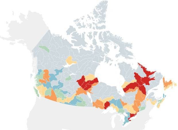
WATER COLOURS
A detailed breakdown of 167 subwatersheds reveals the environmental pressures that different parts of Canada’s water system face. Here’s what the indicators mean
Map legend

Table of contents
Overall stress level • Pollution • Alteration of water flow • Water use • Habitat loss • Fragmentation of ecosystems • Invasive species • Climate change
1. OVERALL STRESS LEVEL

The national assessment breaks Canada’s water system into 167 subwatersheds and finds that nearly all of them are currently the subject of some form of environmental disturbance, with multiple threats at play in some of the most affected regions. Areas at greatest risk tend to match up with population density, farming and heavy industry. Two regions – Eastern Lake Huron and the Lake Ontario and Niagara Peninsula subwatershed – share the dubious distinction of being the most disturbed in Canada because of a combination of seven threat factors, including high pollution levels, water use and fragmentation, among others shown in the accompanying maps.
(Return to map legend)
2. POLLUTION

Pollution remains the most serious threat to freshwater in the short term. The assessment combines data on a variety of pollution sources to reveal a high degree of stress across nearly the full length of Canada’s southern border. In many regions, point source pollution including wastewater effluents, industrial discharges and urban runoff are the largest contributors while agricultural contamination, including nitrogen, phosphorus and pesticides, dominates in the Prairies and Southwestern Ontario. Two other sources – pipeline incident and pollution from transportation mishaps – mainly account for why the zone of very high stress reaches up into northern Alberta.
(Return to map legend)
3. ALTERATION OF WATER FLOW
Large dams and reservoirs serve to disrupt the flooding cycles and variations in flow levels that are natural to all river systems. Among the 12 subwatersheds with very high alteration of flows is the Churchill River in Labrador, where the Muskrat Falls hydroelectric megaproject is located. Another is the La Grande subwatershed in Quebec, home to the largest hydroelectric station in Canada. While the majority of Canada’s northern river systems are currently unaltered by dams, the picture could change dramatically in the future because of the central role hydroelectric power development is expected to play in helping Canada meet its greenhouse gas emission targets.
(Return to map legend)
4. WATER USE
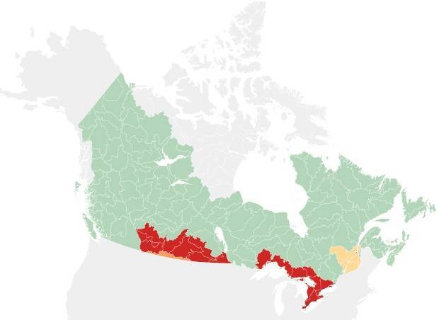
Most of Canada has not seen the removal of vast quantities of freshwater from ecosystems for agricultural production and other uses. But in 17 subwatersheds, the threat posed by the overuse of water is high or very high. These are located in prime agricultural land along the South Saskatchewan and Assiniboine-Red River systems and in the Great Lakes and St. Lawrence regions. Many are part of the boundary waters that Canada shares with the United States. The analysis also includes water intake for drinking water, manufacturing and mining but not the oil and gas industry.
(Return to map legend)
5. HABITAT LOSS

The assessment shows a significant loss of ecosystems in more than half of Canada’s 167 subwatersheds. In the southern part of the country, the decline is mainly due to conversion of natural landscapes into farmland while in a broad swath of the north, from the Yukon to central Quebec, the main driver of habitat loss is forestry. In residential areas, impervious, artificial surfaces such as paved roads, driveways, parking lots and rooftops disrupt natural habitats while increasing the runoff of pollutants into watersheds.
(Return to map legend)
6. FRAGMENTATION OF ECOSYSTEMS

In addition to habitat loss, structures such as dams, roads and railways serve to divide freshwater ecosystems, impede migration of fish and other species, and alter the flow of nutrients. The negative results includes a loss of genetic diversity in aquatic species. A total of 61 subwatersheds, mostly in southern Canada where roads are most numerous, show a very high loss of connectedness. In the North, logging and mining roads are the primary causes of fragmentation.
(Return to map legend)
7. INVASIVE SPECIES

A growing influx of invasive plants and animals has reduced biodiversity and changed the balance of ecological communities in a number of subwatersheds, most notably in Southwestern Ontario where native species are already under high stress due to other risk factors. This threat was among the more challenging of the seven to measure because it is easier to demonstrate the presence rather than the absence of a species that is not native. The threat level only indicates invasive species that are already known to be present in a given watershed, not those that pose likely future threats, such as Asian Carp in the Great Lakes.
(Return to map legend)
8. CLIMATE CHANGE

While climate change currently presents a low or moderate risk across most of Canada today, it is the stressor that is most likely to play a major role in watershed health in the future. Climate projections include more frequent extreme weather events such as flooding and severe droughts that will further tax water systems. More broadly, even small shifts in temperature and precipitation can translate into profound effects on flow rates and on the way ecosystems function. In terms of watershed health, climate change is expected to become important as an amplifier of other threats.
(Return to map legend)
CANADA’S WATER: MORE FROM THE GLOBE AND MAIL


No comments:
Post a Comment