
A friend put me on to a couple of fantastic articles on Google’s latest offering – Google Timelapse.
The first article, written by Jeffrey Kluger, can be found on Time’s website: Timelapse.
Aman Kazemi has also written on Timelapse for CBC. See “Google’s new Timelapse Feature showcases the changing globe”
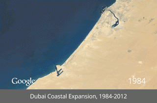
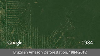
Timelapse lets you go anywhere in the world and mark geological and urban changes over a 26 year period between 1986 and 2012.
The project is part of an ongoing collaboration between the USGS and NASA called Landsat, which consists of millions of satellite images of the earth's surface. Google compiled these into 1.8 trillion pixels per frame images, which, according to the Time feature, is "the equivalent of 900,000 high-def TVs assembled into a single mosaic."
The result is incredible – a seamless moving image of our changing earth – and will serve as a powerful tool for teaching students about the implications of human-environment interactions
The result is incredible – a seamless moving image of our changing earth – and will serve as a powerful tool for teaching students about the implications of human-environment interactions
To highlight the technology's capabilities, the project's designers have featured a handful of geographical locations that help to illustrate the technology's potential in a particularly vivid way.
A couple of the best examples include:
The Retreat of the Columbia Glacier in Alaska

Urban Sprawl in Las Vegas

Dubai Coastal Expansion
Amazon Deforestation
No comments:
Post a Comment