
Original post: Adele Peters for co.EXIST
On a new world map of smog, a giant dark bubble hovers over Beijing. The city, now in the middle of its first-ever emergency "red alert" for air pollution, has closed schools and temporarily taken cars off the road as smog keeps getting worse.
But scrolling around the map—which updates pollution levels in real time—it's quickly obvious that Beijing isn't the only place with a problem. While cities with blue bubbles have clean air, the darker the bubble gets, the more polluted it is.
In New Delhi on Monday, the air quality index made it up to 377 (Beijing was 253). In the U.S., the EPA considers any measurement over 200 very unhealthy, and over 300 hazardous. On the map, a gray cloud hangs over a big chunk of China, and several other cities in India fall into the "extreme pollution" category. If you click on other cities, like New York, the pollution levels are high enough that the site recommends taking it easy with exercise outside.
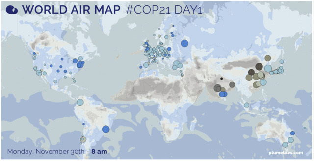
The map, from a startup called Plume, uses open data from air quality monitors in 40 countries around the globe. The company already had apps (iOS, Android) designed for specific cities, which you can use to see when might be the safest time to go for a run or take your baby to the park. But they wanted to lay out all of their data in a single visualization, unveiled for the international climate talks in Paris taking place this week.
"Air pollution is a major environmental health issue all around the world," says Romain Lacombe, CEO and founder of the Paris-based Plume Labs. "We wanted to show that it’s an issue we all face—and must work together to solve. The world air map does just this: it reveals the invisible by visualizing the pollution in the air we breathe, live and all around the world, rather than city by city."

In cities where air pollution isn't tracked or data isn't publicly available, the startup uses large-scale simulation models to estimate pollutants from meteorological research and how that pollution might move. In the cities that have open data, the app tries to predict how smog levels will change throughout the day based on past patterns.
He's hoping the global map can serve as a reminder that carbon emissions are already a problem. Every year, 7 million people die because of air pollution. "Our aim with this map is to visualize the global pandemic of air pollution in order to raise awareness of the importance of clean air for our health," says Lacombe. "Air pollution is the first symptom of climate change."
[All Photos: Plume]
No comments:
Post a Comment