Visitors

Thursday, September 8, 2016

To stop Earth's sixth extinction, a biologist says we must give up half the planet

Edward O. Wilson
Jun. 15, 2016, 6:13 AM 
Original post: Tech Insider


Germany's Chancellor Angela Merkel (wearing blue jacket) and delegates look at a computerized model of the earth "Geo-Cosmos" while visiting Miraikan (National Museum of Emerging Science and Innovation) in Tokyo. Reuters/Issei Kato


The following is an excerpt from "Half-Earth: Our Planet's Fight For Life," by Edward O. Wilson.

The global conservation movement has temporarily mitigated but hardly stopped the ongoing extinction of species.

The rate of loss is instead accelerating.

If biodiversity is to be returned to the baseline level of extinction that existed before the spread of humanity, and thus saved for future generations, the conservation effort must be raised to a new level.

The only solution to the “Sixth Extinction” is to increase the area of inviolable natural reserves to half the surface of the Earth or greater.

This expansion is favored by unplanned consequences of ongoing human population growth and movement and evolution of the economy now driven by the digital revolution. But it also requires a fundamental shift in moral reasoning concerning our relation to the living environment.

At the end of the day, the central question of biodiversity conservation is how many of the surviving wildlands and the species within them will be lost before the extinction rate is returned to the prehuman level.

The prehuman rate is now put at one to ten species extinguished per million species each year.

In terms of a human life span that primordial rate is infinitesimal, essentially zero in conservation thinking.

(Keep in mind also that as many as six million contemporary species remain undiscovered by scientists.)

Yet it also means that the current rate of extinction of the well-known species is up by a multiple of close to one thousand and accelerating — despite the heroic best efforts of the global conservation movement.

Unstanched hemorrhaging has only one end in all biological systems: death for an organism, extinction for a species.

Researchers who study the trajectory of biodiversity loss are alarmed that within the century an exponentially rising extinction rate might easily wipe out most of the species still surviving at the present time.


Harvard biology professor Edward O. Wilson.AP/Chitose Suzuki


The crucial factor in the life and death of species is the amount of suitable habitat left to them.

The relation between habitat area and number of species has been calculated and refined many times and cited often in scientific and popular literature.

It is that a change in area of a habitat, up or down, results in a change in the sustainable number of species by the third to fifth root, most commonly close to the fourth root.

In this last case, when, for example, 90 percent of the area is removed, the number that can persist sustainably will descend to about a half. Such is the actual condition of many of the most species-rich localities around the world, including Madagascar, the Mediterranean perimeter, parts of continental southwestern Asia, Polynesia, and many of the islands of the Philippines and the West Indies. If 10 percent of the remaining natural habitat were then also removed—a team of lumbermen might do it in a month—most or all of the surviving resident species would disappear.


A Lemur hangs on a tree in Madagascar's Mantadia National Park. AP/Jerome Delay


If, on the other hand, with the relation of sustainable species to the area of their habitat at the fourth root (the approximate median value), the fraction protected in one-half the global surface is about 85 percent. That fraction can be increased by including within the one-half Earth “hot spots,” where the largest numbers of endangered species exist.

Today every sovereign nation in the world has a protected area system of some kind. All together the reserves number about a hundred sixty-one thousand on land and sixty-five hundred over marine waters. According to the World Database on Protected Areas, a joint project of the United Nations Environmental Program and the International Union for Conservation of Nature, they occupied by 2015 a little less than 15 percent of Earth’s land area and 2.8 percent of Earth’s ocean area. The coverage is increasing gradually. This trend is encouraging. To have reached the existing level is a tribute to those who have led and participated in the global conservation effort. But is the level enough to not just slow but halt the acceleration of species extinction?

Unfortunately, it is in fact nowhere close to enough. Might the upward trend conservation efforts have set be enough during the rest of the century to save most of Earth’s biodiversity? That is problematic, but I doubt that it can be, and even then there will be far less biodiversity to save.


REUTERS/Yannis Behrakis


Even in the best scenarios of conventional conservation practice the losses should be considered unacceptable by civilized peoples. The declining world of biodiversity cannot be saved by the piece meal operations in current use alone. It will certainly be mostly lost if conservation continues to be treated as a luxury item in national budgets. The extinction rate our behavior is now imposing on the rest of life, and seems destined to continue, is more correctly viewed as the equivalent of a Chicxulub-sized asteroid strike played out over several human generations.

The only hope for the species still living is a human effort commensurate with the magnitude of the problem. The ongoing mass extinction of species, and with it the extinction of genes and ecosystems, ranks with pandemics, world war, and climate change as among the deadliest threats that humanity has imposed on itself. To those who feel content to let the Anthropocene evolve toward what ever destiny it mindlessly drifts, I say please take time to reconsider. To those who are steering the growth of reserves worldwide, let me make an earnest request: don’t stop, just aim a lot higher.

Populations of species that were dangerously small will have space to grow. Rare and local species previously doomed by development will escape their fate. The unknown species, apparently at least six million in number, will no longer remain silent and thereby be put at highest risk. People will have closer access to a world that is complex and beautiful beyond our present imagining. We will have more time to put our own house in order for future generations. Living Earth, all of it, can continue to breathe.

Excerpted from "Half-Earth: Our Planet’s Fight for Life," by Edward O. Wilson. Copyright © 2016 by Edward O. Wilson. All rights reserved.

Wednesday, July 6, 2016

Painstaking Remake of History's Earliest Elevation Map

A British artist is tracing the curious invention of contour lines.
CityLab
LAURA BLISS
@mslaurabliss
Jun 9, 2016

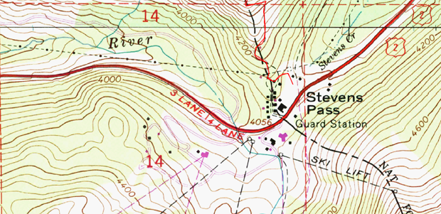
An example of a modern-day relief map using contour lines. (Flickr/Bravenboer)

You’ve seen them on trail maps, road maps, and engineering plans. For centuries, contour lines have been a standard cartographic convention. Used to represent the elevation of land and mountains, to modern map-readers the curving marks are implicit representations of reality, as true as the blue of an oceanic map.

But as with most things in this human-built world, contour lines had to be invented. Their origins lie with Charles Hutton, a British mathematician whose ambitious 1774 survey of a Scottish peak called Schiehallion marked their first known use. That map was lost to history, but his original charts and tables of survey points were not.

Now, a British visual artist has painstakingly recreated Hutton’s map as part of her intensive online investigation of the history of the contour line. Karen Rannused Hutton’s centuries-old data to create a four-foot-square map of Schiehallion, mimicking Hutton’s draftsmanship and handwriting. She also turned those data points into an elegant 3-D model. Alongside artifacts from Hutton’s research, both of these cartographic works of art are on view at the Literary and Philosophical Society in Newcastle, where Rann currently lives and where Hutton once called home.

It’s an effort to resuscitate the importance of Hutton and his contribution to mathematics and cartography, says Rann, who learned about Hutton’s story from a short television program.

“I thought there would be a book about the invention of contour lines, but no one has written it,” she tells CityLab. “And the map that Charles Hutton had drawn is missing. There was this whole detective story and nobody was bothering with it.”

A detail from Rann’s re-created map. (Courtesy of Karen Rann)

It’s an enchanting story of the Enlightenment era. Hutton didn’t invent contour lines in order to represent Schiehallion’s 3,500-foot height. Rather, he created them to solve a problem with which he’d been tasked: weighing the mountain.

This project was all part of a grant from the Royal Society to calculate the weight of the Earth using Newton’s theory of gravitation, led by the astronomer Nevil Maskelyne. This required several challenging steps. The first involved dangling perfectly vertical pendulums from the mountain’s peak to measure the gravitational pull of the mountain, and determining from that, following Newton, its weight. The second was to calculate the volume and density of the mountain, which the scientists would then scale up to weigh the entire planet.

How would you set about weighing a mountain? Perhaps inspired by isobath lines—which had been already been used to show water depth—Hutton broke his task down into parts. The Institute of Mathematics and its Applications, a U.K. professional society, explains:


[Hutton] divided the mountain up into horizontal slices at regular intervals and worked out the volume of each slice. This was relatively straight forward as the mountain was chosen for its symmetrical nature. He then simply added the volume of each slice together to give the volume of the whole mountain. In [mapping this out], he had invented the idea of contour lines still used to this day.

Impressively, Maskelyne and Hutton did manage to estimate the weight of the planet within a 20 percent margin of error, and the Schiehallion experiment has gone down as one of the most influential in history. By the 19th century, Hutton’s contour lines would be adapted by European mapmakers to depict elevation—an essential referent for the industrial era’s new focus on mining and building railways and roads.
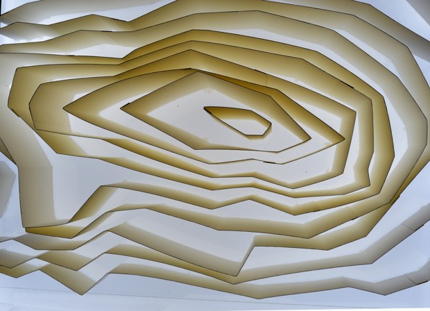
Rann’s 3D model of Schiehallion, according to Hutton’s contour lines. (Courtesy of Karen Rann)

But Hutton’s contributions have flown under the radar of history, says Rann, who can’t completely explain why she felt such a kinship to him. It’s partly their shared homeland, partly the fact that she just loves maps. “It’s hit a chord with a lot of people here, as well,” she says.

But on her blog, Rann waxes a little more poetic about what might make contour lines so enchanting:

Maps are usually drawn to define boundaries, often for defence or attack; or they are drawn for travellers, or landowners wanting to quantify what they possess. These maps are filled with symbols that represent things visible in that landscape: woods and windmills, roads, rivers, bridges and mountain ranges.

The maps explored here were the first to include those tentative lines that expose a quality of our world needing to be understood, to be calculated or defined, through the use of a line or lines which are not visible within the landscape because they are not there.

Hutton may not have intended to invent the contour line, but somewhat like Newton, he showed the world an invisible quality that was indispensable for understanding the world. Map-readers are forever grateful. 

Rann’s 3D model of Schiehallion, according to modern Ordnance Survey contour lines (left), compared to Rann’s 3D model of Schiehallion following Hutton’s contour lines. (Courtesy of Karen Rann)

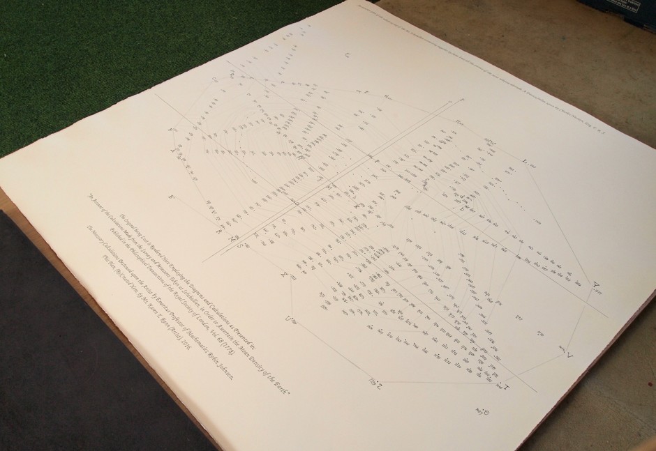
Karen Rann’s re-creation of the original Hutton survey map. (Courtesy of Karen Rann)

Friday, July 1, 2016

Maps have "north" at the top but it could have been different

BBC
Caroline Williams

15 June 2016

Imagine looking at the Earth from space. What is at the top of the planet? If you said the North Pole, you probably wouldn’t be alone. Strictly speaking, you wouldn’t be right either.

The uncomfortable truth is that despite almost everybody imagining that the world is this way up, there is no good, scientific reason to think of north as being the roof of the world.

The story of how it came to be considered to be that way is heady mix of history, astrophysics and psychology. And it leads to an important conclusion: it turns out that the way we have decided to map the world has very real consequences for how we feel about it.

Navigating brain

Understanding where you are in the world is a basic survival skill, which is why we, like most species come hard-wired with specialised brain areas to create cognitive maps of our surroundings. Where humans are unique, though, with the possible exception of honeybees, is that we try to communicate this understanding of the world with others. We have a long history of doing this by drawing maps – the earliest versions yet discovered were scrawled on cave walls 14,000 years ago. Human cultures have been drawing them on stone tablets, papyrus, paper and now computer screens ever since.


"It is only within the last few hundred years that north has been consistently at the top"

Given such a long history of human map-making, it is perhaps surprising that it is only within the last few hundred years that north has been consistently considered to be at the top. In fact, for much of human history, north almost never appeared at the top, according to Jerry Brotton, a map historian from Queen Mary University, London and author of A History of the World in Twelve Maps. “North was rarely put at the top for the simple fact that north is where darkness comes from,” he says. “West is also very unlikely to be put at the top because west is where the sun disappears.”

Confusingly, early Chinese maps seem to buck this trend. But, Brotton, says, even though they did have compasses at the time, that isn’t the reason that they placed north at the top. Early Chinese compasses were actually oriented to point south, which was considered to be more desirable than deepest darkest north. But in Chinese maps, the Emperor, who lived in the north of the country was always put at the top of the map, with everyone else, his loyal subjects, looking up towards him. “In Chinese culture the Emperor looks south because it’s where the winds come from, it’s a good direction. North is not very good but you are in a position of subjection to the emperor, so you look up to him,” says Brotton.


The Kangnido map, a Chinese-influenced Korean map from 1402 (Credit: Wikipedia)


Given that each culture has a very different idea of who, or what, they should look up to it’s perhaps not surprising that there is very little consistency in which way early maps pointed. In ancient Egyptian times the top of the world was east, the position of sunrise. Early Islamic maps favoured south at the top because most of the early Muslim cultures were north of Mecca, so they imagined looking up (south) towards it:


Muhammad Al Idrissi’s map Tabula Rogeriana from 1154, upside down with north at the top (Credit: Wikipedia)


Christian maps from the same era (called Mappa Mundi) put east at the top, towards the Garden of Eden and with Jerusalem in the centre.


The Hereford Mappa Mundi from 1300 (Credit: Wikipedia)


So when did everyone get together and decide that north was the top? It’s tempting to put it down to European explorers like Christopher Columbus and Ferdinand Megellan, who were navigating by the North Star. But Brotton argues that these early explorers didn’t think of the world like that at all. “When Columbus describes the world it is in accordance with east being at the top,” he says. “Columbus says he is going towards paradise, so his mentality is from a medieval mappa mundi.” We’ve got to remember, adds Brotton, that at the time, “no one knows what they are doing and where they are going”.


"Mercator’s world map, from 1569, was a defining moment in north-up map-making"

Mercator’s world map, from 1569, was almost certainly a defining moment in north-up map-making. His map was famously the first to take into account the curvature of the Earth, so that sailors could cross long distances without overshooting the mark. Again, though, Brotton says that north had little to do with it. “Mercator projected the poles to infinity. He says in his description that it doesn’t matter because we are not terribly interested in sailing to them. North is at the top but nobody cares about north because we’re not going there.”

Even so, he could have put the map either way up. Perhaps the choice was simply because the Europeans were doing most of the exploring at the time: in the northern hemisphere, there is far more land to explore and far more people.


The 1569 Mercator map of the world (Credit: Wikipedia)


Whatever the reasons, north up is an idea that seems to have stuck. Take this famous Nasa image from 1973. This photograph was actually taken with south at the top, because the astronaut who took it was spinning around at the time. Nasa decided to flip it over to avoid confusing people.


This image of Earth was photographed this way round, but flipped before publication (Credit: Nasa)


When you start looking at the Earth from space though, the idea of it being any particular way up starts to make even less sense. It’s true that, as we all learned in school, the Earth lines up along the same plane as all of the other planets in the solar system because they all formed out of the same cloud of spinning dust. It is also true, though, that this picture could just as easily be put upside down or with the Sun at the top or bottom, depending on where in space you happen to be looking from.


(Credit: Nasa)

And compared to the rest of the Milky Way, our entire solar system is off kilter by about 63 degrees.

While astronomers have found that stars and planets align with their neighbours in similar ways all over space, Daniel Mortlock, an astrophysicist at Imperial College London, says that this is only true at a tiny scale compared to the vastness of the Universe. “As far as we astronomers can tell, there really is no ‘up’ or ‘down’ in space,” he says.

So the answer to the question of which way up is the Earth is simple: it is not any particular way up and there is no good reason other than a historical superiority complex to think of north as being the top of the world.

Yet is it time to start embracing a different view of the planet from the one we are used to? Perhaps, because evidence from psychology suggests that our north-up culture might be polluting the way we think of what is valuable in the world.


Could there be a northern bias that shapes how we think about some parts of the planet? (Credit: Nasa)


A well-known bias in psychology reveals that most people think of north as being ‘up’ and south, ‘down’. Brian Meier, a psychologist at Gettysberg College in Pennsylvania, has also found that people unconsciously process positive words as if they were higher in space than negative ones. So he wondered whether these two things, north = up and good = up affect the value that people put on different areas on a map.

It isn’t too much of a stretch to think that people are less likely to care about countries that are ‘lower’ than them

Sure enough, when shown a map of a hypothetical city and asked where they would like to live, people were significantly more likely to choose an area in the north of the city. And when another group of people were asked where fictitious people of different social status would live, they plotted them on the map with the richest in the north and poorest in the south.

It isn’t too much of a stretch to think that people are less likely to care what happens in countries or regions that are ‘lower’ than them on the map or globe.

The good news is that in Meier’s experiments the relationship between ‘north’ and ‘good’ was eliminated by one simple thing – turning the map upside down. So perhaps the world might get a little fairer if we just took a look at it another way up now and again. South-up maps are easily available online. It is also something that Mortlock is very much in favour of: “As an Australian, I think it should be done more often,” he says.

If nothing else, it’s a sure-fire way to make the world seem fresh, and unexplored, once more. With so few earthbound discoveries left for our generation to make, all we can do is – to paraphrase Marcel Proust – look again at the world we’ve got, but this time, through different eyes.

Wednesday, June 29, 2016

Take A Video Tour Of The Doomsday Seed Vault In The Arctic Circle


The seed cache is meant to survive every kind of apocalypse.

Co:exist
ADELE PETERS 06.08.16 11:26 AM

Buried 500 feet inside a mountain north of the Arctic Circle in Norway, the Svalbard Global Seed Vault is an attempt to save copies of every seed used to grow food in the world. In theory, it should last 1,000 years, safe from climate change, nuclear war, or an asteroid.

A recent video takes viewers on a tour, showing how the vault tunnels into the mountain and where the seeds—now numbering more than 860,000, from all around the world—are being stored until they're needed.


Because the vault is inside permafrost, the seeds will stay cold even if the power fails. The vault is also high enough on the mountain that even if all the ice in the world melted, the building would stay above sea level. Because it's so remote—the farthest north that it's possible to fly on a scheduled flight—the location also helps protect it from human destruction.

In a post-apocalyptic world, the seeds could be used to rebuild agriculture. But the vault is meant to be useful even without a global disaster. In 2015, Syrian researchers made the first withdrawal, pulling out backup seeds they had originally deposited from a local seed bank that had to be abandoned because of war. Now, those seeds will be used to continue research about which crops can best survive drought as the climate changes.

When it's full, the vault will hold as many as 4.5 million varieties of crops, and 2.5 billion seeds.

Tuesday, June 28, 2016

Gateway to the Underworld’ in Siberia is a warning to our warming planet

Such slumps have been ‘increasing in extent and intensity’ in the frozen north, scientists say
Ian Johnston Environment Correspondent
Independent
Friday 3 June 2016

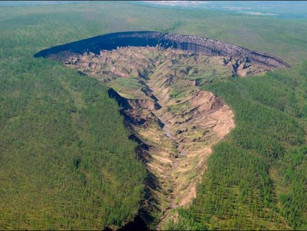
The Batagaika crater in Siberia is widening by up to 20m a year and is a sign of the rate at which the world is warming


It is known as “the Gateway to the Underworld” by local people who fear to go near the massive crater that suddenly appeared in the frozen heart of Siberia.

And they are right to be afraid.

For as the permafrost melts, the world’s biggest “megaslump” is expanding rapidly. Already about a kilometre long and 90m deep, it is widening by up to 20m a year, making walking near its precipitous edges a dangerous pursuit.

But Batagaika crater, which first appeared about 25 years ago, is also a sign of the rate at which the world is warming – smaller ones have been appearing increasingly across the northern hemisphere.

The melting of the permafrost represents one of humanity’s greatest fears for it contains vast amounts of methane, a greenhouse gas much more potent than carbon dioxide.

If it were all to melt – a process that would start on an epic scale after about four degrees of warming – it would likely tip the planet into an extreme scenario the full horror of which is hard to describe.

Professor Julian Murton, a geologist at the University of Sussex, has just returned from a trip to the crater to study its cliffs, which provide a new source of geological information that potentially dates back some 200,000 years.

This includes the last time that the Earth was warmer than it is now, when hippopotamuses and elephants wandered around the future Trafalgar Square


The crater, 1km long and 90m deep, has appeared in the past 30 years (Julian Murton)

Professor Murton said: “In some sense, Batagaika does provide a view to what has happened in the past and what is likely to happen in the future.

“As the climate warms – I think there’s no shadow of a doubt it will warm – we will get increasing thaw of the permafrost and increasingly development of these ‘thermokarst’ features. There will be more slumps and more gullying, more erosion of the land surface.

“I think there’s growing evidence over the last few decades that thermokarst activity in the northern hemisphere has been increasing in extent and intensity.”

However, it will be sometime before Siberia begins to melt dramatically. It can still experience temperatures as low as minus -68C.

The Batagaika crater is thought to have begun after local people cut down some trees in the 1980s or early 1990s.

“Once you disturb the vegetation or soil above permafrost that can often set in train events that lead to the melting of ice within the permafrost,” he said.

“Cutting down of vegetation … removes some of the insulation that keeps the ground cool and that allows the summer heat to penetrate deeper into the ground.”

While the cliff edges are treacherous, the bottom of the crater is also something of a horror show.

Professor Murton compared it to the Badlands of the south-west US, full of ravines and gullies.

The remains of animals such as mammoths, musk ox and horses and ancient tree stumps can also be seen.

However, Professor Murton confirmed he had not found any sign of a mysterious tunnel leading to an underworld, physical or spiritual.

“At the bottom of the slump is rock … I haven’t seen any gateway to hell,” he said.

And while the permafrost can contain large amounts of methane, Professor Murton said there was “probably not a lot” in this particular area.

“You need waterlogged conditions for generating methane. It is pretty wet in the bottom of the slump, so it’s possible there’s some methane coming out of there,” he said.

But the crater, he said, was dangerous to people in the area simply “because this thing is growing remarkably quickly”.

“If you’ve got roads or paths nearby, they could easily get consumed as this thing grows … so it poses a hazard to the locals,” he said.

“There’s a lot of underground ice, ice wedges that are 20 to 30 metres high. Once this starts thawing there will be rapid change.”

Friday, June 3, 2016

The Origin Of Geological Terms: Geology

Forbes
MAY 18, 2016
David Bressan ,


I deal with the rocky road to our modern understanding of earth

Opinions expressed by Forbes Contributors are their own.

“…make them like me adorers of the good science of rock-breaking.” - Charles R. Darwin in a letter dated to 1838 to his friend and mentor Charles Lyell


Specimen of geologist in his natural environment

Curiously enough the, first time the word “geology” was used in the modern sense was in the last will of Italian naturalist Ulisse Aldrovandi (1522-1605).

It was in the 17th century that commoners and noblemen alike began collecting natural objects in their cabinets and private museums. The displayed natural oddities and specimens were mostly acquired by chance from lucky discoverers. It was only later that naturalists started to go in the field, even if such an activity was considered more a necessity to gather more specimens than a means to explore the natural world.

In the 18th century, Swiss professor of philosophy Horace-Bénédict de Saussure was one of the first to propose that “savants” should not only collect specimens, but also take observations and exact measurements in the field. (“Savants” was a general term then applied to well educated people interested in philosophy, art and medicine, and sometimes the earth sciences. People interested and dedicated to the slowly emerging fields of “natural history” and “natural philosophy” were more specifically referred as “naturalists” and “natural philosophers.”)


Natural philosophy was interested in all observable phenomena in nature, from the physiological reaction of the body on the summit of Mount Blanc (climbed by de Saussure in 1787) to the rocks composing the mountain. Natural philosophy itself later became divided in three sub-disciplines: zoology (collection of animals), botany (collection of plants) and mineralogy (collection of minerals and rocks). Still all of these disciplines focused more on collecting and simply describing specimens and naturalists were happy doing so.

However miners were more interested how minerals and rocks are distributed in the landscape, if there were certain natural rules much money could be made by following the most rich veins.

In Germany, leading in mining technologies at the time, so the science called “geognosie” (translated maybe in “knowledge about the earth”) evolved from geography. Mapping the distribution of rocks on a map, geognosts tried to project the rock formations also into depth. This science was referred also as “mineralogical geography” or “géographie souterraine”, may the Italian name “anatomia della terra” – anatomy of earth – best describe what it was about.

Geognosie was however more a practical discipline, less interested in formulating theories. You may say geognosie could describe of which rocks a mountain is made of, but it couldn´t explain how a mountain formed.

In 1778, Georges-Louis Leclerc de Buffon stressed in his “Nature’s Epochs” the need to create a geotheory to understand the evolution and structure of earth.

In that same year, the term geology was introduced (hesitantly) in the literature by Swiss naturalist Jean-Andre de Luc in his opus “Letters on Mountains.”


I mean here by cosmology only the knowledge of the earth, and not that of the universe. In this sense, “geology” would have been the correct word, but I dare not adopt it, because it is not in common use.

Despite de Luc’s concerns, geology became synonymous with the proposed theory of earth, a part of cosmology dedicated to the description and explanation of earth and its relationship with animals, plants and humans.

In now addressing my brother -geologists – and under this term I would comprehend all who take an interest in the progress of a science whose problems are inseparably interwoven with the whole study of nature – I have been influenced by the conviction that it is good for us, as workers in the same field, occasionally to pause and question ourselves as to the ultimate bearing of our investigations.
- David Page (1863): “The Philosophy of Geology”

The word geology itself has much older roots, however. In his testament written in 1603, the Italian Renaissance naturalist Ulisse Aldrovandi introduced the term “giologia” to refer to the study of “fossilia” – the unearthed things.

Aldrovandi had tried his whole life to classify nature, and to separate specimens of rocks and fossils from similar looking animals and plants. The science “giologia,” so Aldrovandi’s hope, would study the origin of rocks, minerals, petrified organisms (Aldrovandi recognized some fossils as once living things) and the layers of earth.

Two hundred years later, the name geology would become largely known to the public by the work of many professional rockhounds, like Sir Charles Lyell and, like Charles Darwin. Those rockhounds in turn hoped that many people would follow its call and become geologists (like me).

Interested in reading more? Try:

RUDWICK, M.J.S (2005): Bursting the limits of time – The reconstruction of Geohistory in the Age of Revolution. The University of Chicago Press, Chicago, London: 708

Wednesday, June 1, 2016

Canada defines its new role in the world


Richard Gwyn
Toronto Star
May 24, 2016


We’re an exceptionally successful nation, but only a medium-size one, our capacity to take on international roles is limited


Canada's Foreign Minister Stephane Dion shakes hands with Myanmar's Foreign Minister Aung San Suu Kyi before their meeting at the Ministry of Foreign Affairs in Naypyitaw in April. "Dion has already coined a name for Canadian foreign policy, namely that it will be based on 'responsible conviction,' a term that seems to mean we’ll listen to other countries rather than tell them what to do," writes Richard Gwyn. (REUTERS)


Can Canada make an impact upon the world? Or, even if done well, would a sustained attempt to achieve this kind of stature leave us looking foolish?

That such an effort will be made by this government was signaled by Prime Minister Justin Trudeau at last December’s climate change conference in Paris. There, Trudeau declared that Canada would exercise, “a new leadership role” internationally.

This work has now begun. Beyond argument, it is extensive and it is determined.

The minister of international development, Marie-Claude Bibeau, has just announced a major study of Canada’s badly lagging program of aid to poor countries.

Defence Minister Harjit Sajjan has announced he will complete his project by the end of this year. He’s described his goal as to put together, “a perfect mix of personnel, training and equipment.”


The minister of international trade, Chrystia Freeland, is doing the same for her responsibilities for negotiating trade pacts.

Foreign Affairs Minister Stéphane Dion is the furthest ahead. He’s already coined a name for Canadian foreign policy, namely that it will be based on “responsible conviction,” a term that seems to mean we’ll listen to other countries rather than tell them what to do.

The scale of these studies is unprecedented, and the goodwill that motivates them is genuine. Already, invitations are coming our way. This month Dion took part in the meeting in Vienna of a 24-member group, headed by the U.S. and Russia, that is trying to negotiate a ceasefire in Syria.

These qualities, though, are where the difficulties begin. We’re indeed an exceptionally successful nation. But we are only a medium-size nation.

In several respects, our capacity to take on international roles is decidedly limited. Our military capacity is well-below our national size, indeed it’s one of the smallest proportionately of all the member-states of NATO.

We’re as mingy about foreign aid. The target of the United Nations is that well-off countries should spend 0.7 per cent of their national output on aid. While Britain is at that mark, Canada’s equivalent is a mere 0.28 per cent.

This is to say that we often talk better than we actually do. The most vivid example is Canada’s recent sale of armoured cars to Saudi Arabia where some are certain to be used against that country’s own people. (Earlier, that fear had prompted Sweden to cancel a military sale to the same customer.)

Sometimes, luck makes us look better than we really are. Our taking in 25,000 Syrian refugees with another 10,000 due to join them was a major accomplishment, most especially so in comparison to the bungling of most of the European states. We enjoyed, though, one asset that made it much easier for us to cope with the intake of newcomers. It’s called the Atlantic Ocean.

The attempt to do what we can to make the world a better place, of some bits and pieces of it at least, is well worth undertaking. Dion caught the character of the challenge by his comment, “This is not a choice. It’s a duty”.

Actually, it’s not so much either a choice or duty; rather, it is us.


Richard Gwyn’s column appears every other Tuesday. gwynr@sympatico.ca